
Lübeck's founding district


The Lübeck Gründungsviertel (also called the Gründerviertel ) is an area of around 10,000 square meters in Lübeck's old town . It is one of the oldest development areas in the Hanseatic city of Lübeck . After its extensive destruction in 1942, it was rebuilt according to historical specifications.
location
The founding quarter is in the city center district, in the western area of Lübeck's old town island . It is located between the church of St. Marien zu Lübeck and the banks of the Trave . The founding district is traversed by Alfstrasse , Braunstrasse , Fischstrasse and Mengstrasse . In addition, in the founding district there is the straight cross street between Alfstrasse and Mengstrasse, the Einhäuschen cross street between Braunstrasse and Fischstrasse and the new cross street .
The naming of this area with the designation Gründerviertel or Gründungsviertel is relatively recent; the term can only be identified in the literature in 1948, i.e. at a time when the historical development no longer existed.
history
The Lübeck founding district is one of the oldest settlement areas in Lübeck. As a result of the air raid on March 29, 1942 , numerous historic buildings in the district were destroyed. In the post-war period , from 1955 to 1961, two vocational schools were established in the area. In addition, some streets were changed; so the straightened Krumme Querstraße was added as an extension of the straight cross street.
From the 1990s onwards, plans were made for a “ city repair ” regarding the founding quarter. With the support of UNESCO , it was decided to demolish the schools and develop them according to the historical parcels of land. The future new buildings should adapt to the historical buildings of Lübeck's old town. In 2009, the demolition of the schools began.
During the archaeological excavations between 2009 and 2015, finds were made that point to early development around the year 1180. More than 40 wooden cellars in sleeper-stand construction were uncovered, which were probably part of the city's first warehouses. In addition, brick fragments were found that came from the construction of the first brick houses in Lübeck. Furthermore, pieces of jewelry, coins and various everyday objects could be recovered. 9 million euros were made available for the excavations. The archaeologically examined area extends to approx. 9,000 square meters.
More than 130 architects from all over Europe took part in the architecture competition for the 38 plots of different sizes . Different uses are planned for the newly built area, for example the areas of living, shops, offices and restaurants. Completion should take place by 2020.
The cleared founding quarter from Braunstraße overlooks in October 2017, shortly after the start of the work on the new building

New buildings in Braunstraße (No. 28 to 22), September 2019

New buildings in Alfstrasse (No. 13 to 19), September 2019

New buildings in Fischstrasse (No. 5 and No. 7–9), September 2019

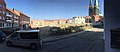
Panorama of the founding quarter from Einhäuschen Querstraße, June 2019


Web links
Individual evidence
- ↑ a b c Information on the Gründungsviertel at gruendungsviertel.de (PDF), accessed on March 23, 2018
- ↑ Article on the founding quarter. Lübecker Nachrichten website. Accessed February 25, 2018.
- ↑ Information page about the Lübeck founding quarter Website of the Hanseatic City of Lübeck. Accessed February 24, 2018.
- ↑ General information on the project Official website of the Gründungsviertel project. Accessed February 25, 2018.
Coordinates: 53 ° 52 ′ 3.4 " N , 10 ° 40 ′ 56.4" E