La Bélgica
| La Bélgica | ||
|---|---|---|
| Basic data | ||
| Residents (state) | 4575 pop. (2012 census) | |
| rank | Rank 98 | |
| height | 359 m | |
| Post Code | 07-0603-0100-5001 | |
| Telephone code | (+591) | |
| Coordinates | 17 ° 34 ′ S , 63 ° 13 ′ W | |
|
|
||
| politics | ||
| Department | Santa Cruz | |
| province | Sara Province | |
| climate | ||
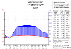
 Climate diagram Warnes |
||
La Bélgica is a country town in the Santa Cruz department in the lowlands of the South American Andean state Bolivia .
location
La Bélgica is the central place of the district ( Bolivian : Municipio ) Colpa Bélgica in the province of Sara . The city is located at an altitude of 359 m on the left bank of the Río Piraí , 32 kilometers above the mouth of the Río Guendá near Portachuelo .
geography
La Bélgica is located in a tropical, humid climate in front of the eastern edge of the Andes mountain range of the Cordillera Oriental . The region was covered by subtropical rainforest before colonization , but is now mostly cultivated land .
The mean average temperature of the region is just under 24 ° C (see Warnes climate diagram), the monthly values fluctuate between 20 ° C in June / July and 26 ° C from November to February. The annual precipitation is about 1300 mm, the monthly precipitation is productive and lies between 35 mm in August and 200 mm in January.
Transport network
La Bélgica is 37 kilometers by road north of Santa Cruz , the capital of the department.
From Santa Cruz, the Ruta 4 highway leads thirty kilometers north to Warnes . Two kilometers before Warnes, a country road leads six kilometers west to the Río Piraí, and after crossing the Piraí bridge, a road connection leads south, which after three kilometers reaches La Bélgica .
population
The population of the village has remained relatively constant over the past two decades:
| year | Residents | source |
|---|---|---|
| 1992 | 4 615 | census |
| 2001 | 5 031 | census |
| 2012 | 4,575 | census |
Due to the history of settlement, the region has only a small proportion of indigenous population . The Quechua population has the largest proportion in the Municipio Colpa Bélgica , 12.2 percent of the population speak the Quechua language.
Individual evidence
- ^ INE - Instituto Nacional de Estadística Bolivia 1992
- ^ INE - Instituto Nacional de Estadística Bolivia 2001
- ↑ INE - Instituto Nacional de Estadística Bolivia 2012 ( Memento of the original from July 22, 2011 in the Internet Archive ) Info: The archive link has been inserted automatically and has not yet been checked. Please check the original and archive link according to the instructions and then remove this notice.
- ↑ INE social data Santa Cruz 2001 (PDF; 5.2 MB)
Web links
- Municipio Colpa Bélgica - Information from the Gobierno Autónomo Departamental ( Spanish )
- Relief map of the Santa Cruz region 1: 250,000 (PDF; 7.88 MB)
- Municipio Colpa Bélgica - General Maps No. 70603
- Municipio Colpa Bélgica - detailed map and population data (PDF; 622 kB) ( Spanish )
- Department Santa Cruz - Social data of the municipalities (PDF; 5.12 MB) ( Spanish )
