
Lai da Vons
| Lai da Vons | ||
|---|---|---|

|
||
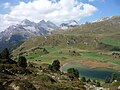
| Aerial view from the north. In the background on the right the Pizzo Tambo | ||
| Geographical location | Andeer municipality , Viamala region , Graubünden , Switzerland | |
| Tributaries | Perfilsbach | |
| Drain | Töbelibach to Sufnersee | |
| Data | ||
| Coordinates | 749 193 / 161210 | |
|
||
| Altitude above sea level | 1991 m above sea level M. | |
| surface | 2.9 ha | |
| length | 260 m | |

The Lai da Vons is a mountain lake in the canton of Graubünden . The name is derived from Rhaeto-Romanic vonn for "Mulde".
The lake is at an altitude of 1991 m above sea level. M. in the area of the municipality of Andeer . He is a nearly three-kilometer mountain trail of Sufers to reach out (about 560 vertical meters). There is a bus in summer.
The lakeshore is a flat moor of regional importance, on the western bank there is swinging lawn.
The geographer Conradin Burga pointed out human traces on the Lai da Vons from around 2800 BC. Chr. By. The Lai da Vons pass was an old trade route and connects Andeer with the San Bernardino pass and the Splügen pass, bypassing the Roflaschlucht, which was not yet developed at the time .

Lai da Vons to the southwest from the slight hill at the transition to Schams
Lai da Vons from the east towards the Alperschällihorn

View to the northeast, with TV antenna
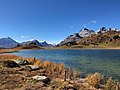
View to the southwest (from left to right Pizzo Tambo , Guggernüll , Einshorn , Teurihorn, Steilerhorn, Alperschällihorn )

Swinging lawn on the west bank


The Grenzbrigade 12 set up the two infantry units A 7840 and A 7841 at the Lai da Vons, each with a bunkered machine gun. The positions have been dismantled. Three masonry high-altitude military shelters are still visible.
Individual scenes from the Heidi film from 2015 were filmed on Lai da Vons .
literature
- Charles Knapp, Maurice Borel, Victor Attinger, Heinrich Brunner, Société neuchâteloise de géographie (editors): Geographical Lexicon of Switzerland . Volume 6: Tavetsch Val - Zybachsplatte, supplement - last additions - appendix . Verlag Gebrüder Attinger, Neuchâtel 1910, p. 419, keyword Vons (Lai Da) ( scan of the lexicon page ).
- National map 1: 25,000, sheet 1235 Andeer. Federal Office for Topography, Wabern 2015, ISBN 978-3-302-01235-3 .
Web links
Individual evidence
- ↑ The lake is registered as property no. 41 with an area of 29,203 m² at the Hinterrhein land registry. See also BGE 113 II 236 .
- ↑ measured in the geoserver of the Swiss Federal Administration ( notes )
- ↑ Andrea Schorta: How the mountain got its name . Small Rhaetian name book with two and a half thousand geographical names of Graubünden. Terra Grischuna Verlag, Chur and Bottmingen / Basel 1988, ISBN 3-7298-1047-2 , p. 150 .
- ^ Conradin Burga: Pollen analysis and geomorphological studies on the history of vegetation and the Quaternary geology of the Schams and the San Bernardino pass area (Graubünden, Switzerland). Dissertation University of Basel, 1979.
- ^ Otto Flückiger: Passes and borders. In: Mitteilungen der Geographisch-Ethnographische Gesellschaft Zürich , Volume 27–28 (1926–1927), pp. 39–65, p. 50.
- ↑ A 7840 at 748 600/162 000 , A 7841 at 749 400/161 160
- ↑ BBl 2000 3957 Federal Gazette No. 28 of July 18, 2000, p. 3957.
- ↑ B 02378 Glattenberg, property no. 216 owned by the Military History Foundation Graubünden ; B 02379 See, property no. 21 owned by the Swiss Confederation ; B 02380 Wasserscheide, property no. 218 owned by the Swiss Confederation
- ↑ Dreampix