Laingsburg (municipality)
| Laingsburg Laingsburg (Municipality) Local Municipality |
|
|---|---|
 |
|
| Basic data | |
| Country | South Africa |
| province | Western cape |
| District | Central Karoo |
| Seat | Laingsburg |
| Residents | 8289 (October 2011) |
| key | WC051 |
| ISO 3166-2 | ZA toilet |
| Website | www.laingsburg.gov.za (English) |
| politics | |
| mayor | Aubrey Marthinus |
Coordinates: 32 ° 12 ′ S , 20 ° 51 ′ E
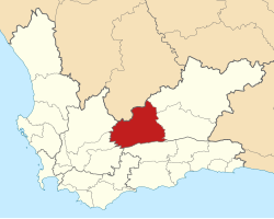
Laingsburg is a municipality in the district of Central Karoo in the province of Western Cape in South Africa . In 2011, 8,289 people lived here. The seat of the municipal administration is Laingsburg .
The parish is named after John Laing, Commissioner of the Crown in the Cecil Rhodes cabinet .
geography
The total area of the municipality is 8,781 km².
Neighboring communities
Laingsburg borders in the northeast on Beaufort West , in the east on Prince Albert , in the south on Kannaland , in the west on Langeberg (so far all Western Cape) and in the northwest on Karoo Hoogland (in the North Cape ).
Cities
- Bergsig
- Gold Nerville
- Laingsburg
- Matjiesfontein
population
In 2011, the municipality had 8,289 inhabitants, making it the smallest municipality in the province by population. 79% of the population were colored , 13.3% white and 7% black.
90.1% of the speakers were Afrikaans, 1.6% English and 1.2% IsiXhosa .
Web links
- Portrait at localgovernment.co.za (English)
Individual evidence
- ^ Municipal boundaries South Africa
- ↑ Meaning of the name municipalities ( Memento from August 29, 2019 in the Internet Archive ) (English)
- ↑ http://www.statssa.gov.za/?page_id=993&id=laingsburg-municipality