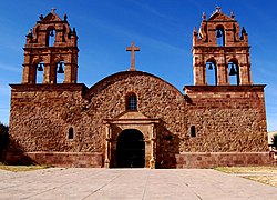
Laja (Bolivia)
| Laja | ||
|---|---|---|
 Iglesia de Laja |
||
| Basic data | ||
| Residents (state) | 876 pop. (2012 census) | |
| height | 3861 m | |
| Post Code | 02-1202-0103-7001 | |
| Telephone code | (+591) | |
| Coordinates | 16 ° 32 ′ S , 68 ° 23 ′ W | |
|
|
||
| politics | ||
| Department | La Paz | |
| province | Los Andes Province | |
| climate | ||
 Climate diagram Viacha |
||
Laja (named after the rock of the same name found there) is a town in the La Paz department in the highlands of the South American Andean state of Bolivia .
The place is historically significant as the place where La Paz was first founded (1548).
Location in the vicinity
Laja is the capital of Municipalities (municipality) Laja in Los Andes Province and is located at an altitude of 3861 m . To the north and south of Laja, the vast plain of the Bolivian highlands extends to Lake Titicaca in the north and beyond Calamarca in the south.
geography
Laja is located on the Bolivian plateau between the Andes mountain ranges of the Cordillera Occidental in the west and the Cordillera Central in the east. The region's climate is typical of the time of day , with average temperatures fluctuating more during the day than during the year.
The mean annual temperature of Viacha is just under 9 ° C, the annual precipitation is around 600 mm (see Viacha climate diagram). The monthly average temperatures fluctuate only slightly between 6 ° C in July and 10 ° C from November to February. The months May to August are arid with monthly precipitation of less than 15 mm, in the southern summer months of January and February monthly precipitation of more than 100 mm is measured.
history
On October 20, 1548, Alonso de Mendoza founded the city of Nuestra Señora de La Paz in place of today's Laja as a stop on the trade route from Potosí to Callao in Peru . Three days later, a location around 25 km to the east was chosen for the new settlement and some of the village residents were relocated there because it offered better protection from bad weather.
The church , which was also built in 1548 and has been expanded several times, is particularly well-known for tourists and was mostly built with stones from the nearby Tiahuanaco . The church has been cared for since 2002 (as of 2011) by Divine Word Missionaries and Divine Divine Mission Sisters , two independent international Roman Catholic religious orders . At the entrance to Laja, a stone stele with the inscription "Laja - cuna de La Paz" (in German: "Laja, the cradle of La Paz") reminds of the historical importance of the place for the history of La Paz.
Transport network
Laja is home to a municipal administration, police, hospital and the offices of several non-governmental organizations . The village is 38 kilometers by road west of La Paz , the capital of the department.
From La Paz, the paved road Ruta 2 leads west to El Alto and another five kilometers in a north-westerly direction. Then the Ruta 1 branches off to the west and after another twenty kilometers reaches Laja . The Ruta 1 then continues on to Tiahuanaco and Lake Titicaca. Except in the center, all side streets in Laja are unpaved. Only a few public facilities in town have telephone and internet access.
population
The population of the village has increased by around a third in the past two decades:
| year | Residents | source |
|---|---|---|
| 1992 | 561 | census |
| 2001 | 707 | census |
| 2012 | 876 | census |
Due to the historical population development, the region has a high proportion of Aymara population, in the municipality of Puerto Pérez 97.2 percent of the population speak the Aymara language .
economy
A flatbread ( pan de laja ) is produced in the village, which is in demand far beyond the village limits and thus secures the livelihood of many families. The largest festival in the village takes place on December 9th in honor of the "Virgin of the Immaculate Conception" ( Virgen de la Inmaculada Concepción ). The cityscape is characterized by small grocery stores and a few bars. Several times a day, private minibus companies offer trips to El Alto and La Paz from the center.
Individual evidence
- ^ INE - Instituto Nacional de Estadística Bolivia 1992
- ^ INE - Instituto Nacional de Estadística Bolivia 2001
- ↑ INE - Instituto Nacional de Estadística Bolivia 2012 ( Memento of the original from July 22, 2011 in the Internet Archive ) Info: The archive link has been inserted automatically and has not yet been checked. Please check the original and archive link according to the instructions and then remove this notice.
- ↑ INE social data (PDF; 12.2 MB)
Web links
- Relief map of the La Paz region 1: 250,000 (PDF; 11.07 MB)
- Municipio Laja - General Maps No. 21202
- Municipio Laja - detailed map and population data (PDF; 467 kB) ( Spanish )
- Departamento La Paz - social data of the municipalities (PDF; 11.63 MB) ( Spanish )
