Lake Eyre National Park
| Lake Eyre National Park | ||
|---|---|---|
| Salt crust | ||
|
|
||
| Location: | South Australia , Australia | |
| Specialty: | Salt pan | |
| Next city: | Marree | |
| Surface: | 13,492.51 km² | |
| Founding: | 1985 | |
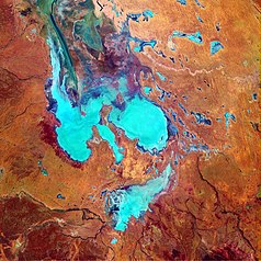
| Satellite photo | ||
The Lake Eyre National Park , which covers an area of 12,880 square kilometers, is located in South Australia on the east bank of the salt lake Lake Eyre , about 750 kilometers north of Adelaide and 60 kilometers east of William Creek . The park includes the northern salt lake (Lake Eyre North), the southern, smaller salt lake (Lake Eyre South), as well as parts of the Tirari Desert .
This park is located in one of the driest areas in Australia. If the lake is completely filled with water by tributaries, and this was the last time in 2000, it is mainly inhabited by pelicans , gulls and ducks. They feed on fish and small crabs that the rivers wash into the lake. In the park there are reptiles such as the Lake Eyre Dragon and growing samphire , the Salt and Blue Bush and diminutive acacia . Since the lake is only filled with water every 25 years on average, it usually has a salt crust up to 46 cm thick.
Sightseeing flights over the park can be chartered from William Creek , Marree or Coober Pedy . Four-wheel drive vehicles and a South Australian Desert Park Pass are required to drive into the park ; a normal car can only drive to Oodnadatta . Outside the park you can camp at Muloorina Station . Only gas stoves are allowed in the park and no open fire. The best time to travel is April to October.
Web links
Individual evidence
- ^ Steve Parish: Australian Touring Atlas . Steve Parish Publishing Pty. Ltd. Archerfield QLD (2007). ISBN 978-1-74193-232-4 . P. 72 + 73


