Lamitsch
|
Lamitsch
Community Rietz-Neuendorf
Coordinates: 52 ° 15 ′ 34 " N , 14 ° 9 ′ 38" E
|
|
|---|---|
| Height : | 102 m above sea level NHN |
| Incorporation : | April 1, 1938 |
| Incorporated into: | Pfaffendorf |
| Postal code : | 15848 |
| Area code : | 033672 |
|
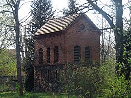
Lamitsch bell tower
|
|
Lamitsch ( Łomnica in Lower Sorbian ) is a residential area belonging to the Pfaffendorf district of the municipality of Rietz-Neuendorf in the Oder-Spree district in Brandenburg . Until it was incorporated into Pfaffendorf on April 1, 1938, Lamitsch was an independent municipality.
location
Lamitsch is about eleven kilometers northwest of Beeskow and twelve kilometers southeast of Fürstenwalde / Spree on the Beeskower Platte . The settlement is structurally directly connected to the Pfaffendorf to the north. Other neighboring towns are Sauen in the east, Görzig in the southeast, the residential area Rietz-Neuendorf in the south, Krachtsheide and Hartensdorf in the southwest and Wilmersdorf in the west.
The federal highway 168 leads through the place Lamitsch. The Fürstenwalde-Ost junction on federal motorway 12 is around nine kilometers from Lamitsch.
history
The Angerdorf Lamitsch was first mentioned in a document in 1490 with the name Lamatzsch . The place name derives from the Lower Sorbian term łamanki from that here on one after windfall refers resulting settlement.
On April 1, 1938, Lamitsch was incorporated into Pfaffendorf . This community merged on December 31, 2001 with other communities of the Glienicke / Rietz-Neuendorf office to form the new community of Rietz-Neuendorf .
Population development
|
|
Territory of the respective year
Web links
Individual evidence
- ↑ Reinhard E. Fischer : The place names of the states of Brandenburg and Berlin. Age - origin - meaning. be.bra Wissenschaft Verlag, Berlin 2005, p. 100.
- ^ Historical municipality register of the state of Brandenburg 1875 to 2005. (PDF; 331 KB) Landkreis Oder-Spree. State Office for Data Processing and Statistics State of Brandenburg, December 2006, accessed on December 21, 2019 .
