
Province of Villa Clara
| Villa Clara | |
|---|---|
  |
|
| Capital | Santa Clara |
| surface | 8,412 km² |
| Residents | 791,216 (2012) |
| Population density | 94.1 inhabitants / km² |
| ISO code | CU-05 |
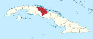
Villa Clara is a province in central Cuba and extends between 22 ° 16 'and 23 ° 09' north latitude and 80 ° 02 'and 80 ° 25' west longitude. Its capital is Santa Clara . The province borders the Atlantic Ocean to the north, the Sancti Spíritus Province to the east and south and the Matanzas and Cienfuegos provinces to the west . The sugar industry and low tourism are the main sources of income for the province.
Until the administrative reform of 1976 Villa Clara formed together with Cienfuegos and Sancti Spíritus the province "Las Villas".
The largest Cuban river, the Río Sagua la Grande (163 km) flows northward into the Atlantic. The mountain Pico Tuerto reaches a height of 919 meters.
The population density is below the Cuban average, the degree of urbanization is 77.8%.
Statistically speaking, there are 1006 men for every 1000 women (i.e. the proportion of women is 49.84%) (2012 figures).
Administrative division
The province is divided into 13 Municipios, which are named after the names of their administrative offices.
The province has 6 cities (in Cuba settlements over 20,000 inhabitants are called cities, Spanish Ciudades ), there are also 60 urban and 462 rural settlements ( Pueblos, Pobladas, Caserío and Batey ).
| Municipio | Total area with islands (km²) 3 |
Residents | Population density (inh / km²) 3 |
||
|---|---|---|---|---|---|
| 2002 1 | 2012 2 | 2016 3 | |||
| Corralillo | 837.30 | 27,367 | 26,843 | 26,089 | 31.2 |
| Quemado de Güines | 332.82 | 22,594 | 22,089 | 21,586 | 64.4 |
| Sagua la Grande | 961.90 | 56.291 | 53,077 | 52,118 | 54.4 |
| Encrucijada | 591.55 | 33,790 | 33,669 | 33,139 | 55.7 |
| Camajuaní | 585.71 | 63,368 | 60,598 | 59,898 | 101.5 |
| Caibarién | 385.76 | 37,980 | 38,485 | 40.102 | 97.3 |
| Remedios | 589.98 | 46,664 | 45,621 | 44,758 | 75.9 |
| Placetas | 656.47 | 71,963 | 68,922 | 68,065 | 105.5 |
| Santa Clara | 668.82 | 236.343 | 240,543 | 245.470 | 362.4 |
| Cifuentes | 415.90 | 33,667 | 28,425 | 27,584 | 66.3 |
| Santo Domingo | 878.07 | 54,076 | 51.013 | 50,035 | 57.2 |
| Ranchuelo | 521.83 | 59,404 | 54,889 | 53,775 | 103.1 |
| Manicaragua | 985.70 | 73,888 | 67,042 | 65,238 | 66.7 |
| Entire province | 8,411.81 | 817.395 | 791.216 | 787.857 | 93.2 |
Census results:
- 1 2002 census
- 2 2012 census
Estimates or calculations at the end of the year:
- 3 2016
Cities
46.4% of the population lived in the six cities in 2012 (Census):
| Santa Clara | 211,925 | Sagua la Grande | 37,713 | Manicaragua | 22,266 |
| Placetas | 39,615 | Caibarién | 33,683 | Camajuaní | 21,924 |
Web links
- Official Portal of the Province (Spanish only)
- Sitio Oficial de Turismo de Villa Clara, Cuba (Spanish and English)
Individual evidence
- ↑ a b c 2012 census (PDF; 257 kB) , ONE
- ↑ Census 2002 ( Memento of the original dated February 3, 2007 in the Internet Archive ) Info: The archive link was inserted automatically and has not yet been checked. Please check the original and archive link according to the instructions and then remove this notice.
- ↑ Anuario Estadístico de Villa Clara 2016 (PDF; 3.3 MB) , ONE
Artemisa |
Camagüey |
Ciego de Ávila |
Cienfuegos |
La Habana |
Granma |
Guantánamo |
Holguín |
Las Tunas |
Matanzas |
Mayabeque |
Pinar del Río |
Sancti Spíritus |
Santiago de Cuba |
Villa Clara
Special-Municipio: Isla de la Juventud
Former provinces: La Habana |
Las Villas |
Oriente