
Pinar del Río Province
| Pinar del Río | |
|---|---|
  |
|
| Capital | Pinar del Río |
| governor | Rubén Ramos Moreno |
| surface | 10,931 km² |
| Residents | 587,026 (2012) |
| Population density | 66.1 inhabitants / km² |
| ISO code | CU-01 |
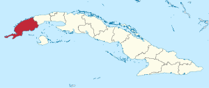
Pinar del Río is the westernmost province of Cuba . Its capital is Pinar del Río . With 10,931 km² it is Cuba's third largest province and is bordered in the east by the Artemisa province . It borders the Gulf of Mexico in the north and the Caribbean in the south .
geography
The 175 km long Cordillera de Guaniguanico forms the backbone of the Pinar del Río province . It rises to 699 meters on the Pan de Guajaibón . To the south and north of the mountains there are largely swampy coastal plains. In the mountains lies the Sierra del Rosario , which is under UNESCO protection. In addition, to the west of it lies the Sierra de los Órganos (Organ Pipe Mountains). In the valley in between, the Valle de Viñales , lies the touristic place Viñales . In this valley there are so-called mogotes, which are overgrown cone karst rocks. Because of the karst subsoil, there are also many caves in this area. There are also underground rivers.
The longest river in the province is the Río Cuyaguateje , which is 112 km long, drains the western part of the Sierra de los Órganos and flows into the Bahía de Cortés . Most of the tree vegetation consists of pine forests ; Of course, the royal palms so typical of Cuba are also omnipresent.
Another interesting region in terms of flora and fauna is the Península de Guanahacabibes biosphere reserve ; this peninsula is also the westernmost point of Cuba. Much of the coast of Pinar del Río was mangrove forest (before deforestation) or is rocky (very sharp rocks due to the erosive forces of the sea); therefore there are only a few sandy beaches.

economy
The main product of the province is tobacco . Around 80% of Cuba's tobacco production comes from the area around Pinar del Río. But sugar cane , rice and citrus fruits are also grown. Livestock is also farmed. Until 1997 , copper was mined in the Minas de Matahambre in the northwest , but it was closed as "uneconomical".
Administrative division

The province of Pinar del Río is divided into eleven municipalities :
- Consolación del Sur (Consolación del Sur)
- Guane (guane)
- La Palma (La Palma)
- Los Palacios (Los Palacios)
- Mantua (Mantua)
- Minas de Matahambre (Minas de Matahambre)
- Pinar del Río (Pinar del Río)
- Sandino (Sandino)
- San Juan y Martínez (San Juan y Martínez)
- San Luis (San Luis)
- Viñales (Viñales)
Until 2010, the Municipios Bahía Honda , Candelaria and San Cristóbal also belonged to the Province of Pinar del Río. Since 2011 they have belonged to the newly created Artemisa province .
Individual evidence
- ↑ Census 2012 (PDF; 257 kB) , ONE
Artemisa |
Camagüey |
Ciego de Ávila |
Cienfuegos |
La Habana |
Granma |
Guantánamo |
Holguín |
Las Tunas |
Matanzas |
Mayabeque |
Pinar del Río |
Sancti Spíritus |
Santiago de Cuba |
Villa Clara
Special-Municipio: Isla de la Juventud
Former provinces: La Habana |
Las Villas |
Oriente