Lechtingen
Lechtingen is a village and part of the municipality of Wallenhorst in the Osnabrück district in Lower Saxony . With 4714 inhabitants (as of November 22, 2017), Lechtingen is the second smallest district in the municipality.
description
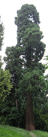
The village borders on the surrounding districts of Rulle , Wallenhorst and Hollage and, to the south, on the districts of Pye and Haste of the city of Osnabrück . Part of the Piesberg , at times the largest quarry in Europe, lies in Lechtingen. On the Lechtinger side of the Piesberg there is an arboretum with a 33 meter high sequoia tree . Another important sight is the restored Lechtingen windmill , where several open-air events take place every year. The Lechtingen windmill is considered to be the place where the idea for the Lower Saxony Milling Day arose, which later became the German Milling Day , which is celebrated every year on Whit Monday .
history
On July 1, 1972, Lechtingen was incorporated into the municipality of Wallenhorst.
politics
Mayor and chief
Until it was incorporated in 1972, Lechtingen had its own mayor.
Mayor:
- 1936–1945: Aloys Stertenbrink
- 1945–1948: Georg Kreuzkamp
- 1948–1956: Aloys Stertenbrink
- 1956–1971: Johannes Werries
- 1971–1972: Kurt Jünemann
Head:
- 1849: Colon Franz Heinrich Riepenhoff
- 1858: Colon Ferdinand Werries
- 1865–1866: Colon Wöstmann
- 1866–1878: Colon Harenburg
- 1878–1884: Colon Heinrich Sprehe
- 1884–1896: Colon Heinrich Riepenhoff
- 1896–1905: Colon Theodor Ebbeskotte
- 1905–1911: Colon Heinrich Riepenhoff
- 1911–1919: Farm owner Konrad Stertenbrink
- 1919–1924: Farm owner August Werries
- 1924–1927: Anton Meyer
- 1927–1936: Farm owner Bernhard Hanesch
coat of arms
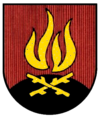
Blazon : In red on a black mountain, two diagonally crossed golden branches, above a golden flame.
There are two interpretations of the place name Lechtingen: Jellinghaus (news about villages and farms around Osnabrück, Osnabrück 1924) as “Lichte Auen”, Professor Bader (1100 years of Wallenhorst, Wallenhorst 1951) as “place near the light signals”. Both interpretations contain the term "light". The design of the coat of arms is based more on the interpretation of Professor Bader. According to this, in ancient times the population was warned of impending dangers by fire signals from the height of the Piesberg, located in the Lechtinger area. The federal colors and the same Lower Saxony state colors appear in the coat of arms. Based on the interpretation of the place name, black here also indicates the night during which the fire was burning, and in red one can foresee the calamity of which the golden flame warns.
Population development
Resident population of the municipality of Lechtingen with territorial status as of May 27, 1970:
| date | Residents |
|---|---|
| May 17, 1939 | 1035 |
| September 13, 1950 | 1491 |
| June 6, 1961 | 1624 |
| May 27, 1970 | 2081 |
| April 30, 2014 | 4865 |
| 22nd November 2017 | 4714 |
Personalities
Food journalist and cookbook author Stefanie Hiekmann and media journalist Stefan Niggemeier grew up in Lechtingen.
Web links
Individual evidence
- ↑ Population data for the municipality of Wallenhorst
- ↑ City of Osnabrück / Terra vita Nature and Geopark: Arboretum with sequoia tree
- ↑ Franz-Josef Albers: The fight over the windmill Lechtingen. How to deal with investors, development agencies and municipal administrations ( memento of the original from December 20, 2015 in the Internet Archive ) Info: The archive link was inserted automatically and has not yet been checked. Please check the original and archive link according to the instructions and then remove this notice. (PDF; 1.3 MB). The millstone . May 2009, pp. 36-39.
- ↑ Windmühle Lechtingen: Mühlentag ( Memento of the original from November 28, 2011 in the Internet Archive ) Info: The archive link was inserted automatically and has not yet been checked. Please check the original and archive link according to the instructions and then remove this notice.
- ^ Federal Statistical Office (ed.): Historical municipality directory for the Federal Republic of Germany. Name, border and key number changes in municipalities, counties and administrative districts from May 27, 1970 to December 31, 1982 . W. Kohlhammer GmbH, Stuttgart and Mainz 1983, ISBN 3-17-003263-1 , p. 258 .
- ^ Franz-Joseph Hawighorst: 1150 years of Wallenhorst . Ed .: Wallenhorst community. Druck- und Verlagshaus Fromm, 2001, Self-government in the areas, p. 846 .
- ↑ Lower Saxony State Administration Office (Hrsg.): Municipal Statistics Lower Saxony 1970. Part 2: Population and Employment, Volume 5: District Osnabrück, Hanover 1973, p. 138.
Coordinates: 52 ° 20 ' N , 8 ° 1' E


