Lehmichsbach
|
Lehmichsbach Back Bach |
||
|
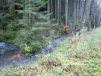
The Lehmichsbach near Overath, 2017 |
||
| Data | ||
| Water code | DE : 2728752 | |
| location |
Rhenish Slate Mountains
|
|
| River system | Rhine | |
| Drain over | Agger → Sieg → Rhine → North Sea | |
| source | west of Overath - Hufenstuhl 50 ° 57 ′ 45 ″ N , 7 ° 16 ′ 31 ″ E |
|
| Source height | 232 m above sea level NHN | |
| muzzle | south of Overath- Rott in the Agger coordinates: 50 ° 57 ′ 13 ″ N , 7 ° 18 ′ 37 ″ E 50 ° 57 ′ 13 ″ N , 7 ° 18 ′ 37 ″ E |
|
| Mouth height | 97.5 m above sea level NHN | |
| Height difference | 134.5 m | |
| Bottom slope | 36 ‰ | |
| length | 3.8 km | |
| Catchment area | 3.239 km² | |
The Lehmichsbach even baking Bach called, is a nearly four-kilometer stream in city Overath in the Rheinisch-Bergisch district . It is a right and west tributary of the Agger .
geography
course
The Lehmichsbach rises west of Overath - Hufenstuhl and flows into the Agger from the right after a run of 3.756 km south of Overath- Rott .
Tributaries
- Huferstuhlsiefen 1.4 km
Nature reserve
The Lehmichsbach flows through the Lehmichsbachtal nature reserve .
Web links
Commons : Lehmichsbach - collection of images, videos and audio files
Individual evidence
- ↑ Fachinformationssystem ELWAS, Ministry of Climate Protection, Environment, Agriculture, Nature and Consumer Protection NRW ( notes ), under the Layer DK5 heights
- ↑ Topographical Information Management, Cologne District Government, Department GEObasis NRW ( Notes )
- ↑ a b Specialized information system ELWAS, Ministry for Climate Protection, Environment, Agriculture, Nature and Consumer Protection NRW ( information ), to be found here under Backenbach
