
Leina (river)
| Leina | ||
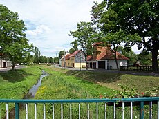
 Leina, Altenwasser and Hörsel in Leina |
||
| Data | ||
| Water code | DE : 416-11? | |
| location | Thuringia , Germany | |
| River system | Weser | |
| Drain over | Hörsel → Werra → Weser → North Sea | |
| source | Leina source at Posseröder Kreuz ( Rennsteig ) 50 ° 48 ′ 42 ″ N , 10 ° 32 ′ 46 ″ E |
|
| Source height | 681.2 m above sea level NN | |
| muzzle | in the Hörsel and near Engelsbach in the Leinakanal Coordinates: 50 ° 54 '9 " N , 10 ° 37' 54" E 50 ° 54 '9 " N , 10 ° 37' 54" E
|
|
| Reservoirs flowed through | Fire control pond | |
| Communities | Finsterbergen , Schönau in front of the forest | |
The Leina is a source river of the Hörsel in the river system of the Weser .
description
The Leina rises at Leinaborn in the Thuringian Forest , hall Tambach-Dietharz in Rennsteig close . After about 2.5 kilometers, the stream is dammed by the Brandleiteteich - an early modern mine and smelter complex was located here in the 15th century.
The stream is noticeably strengthened by further tributaries in the Finsterbergen corridor . In the Leinagrund there were therefore about five sawmills and hammer mills over a distance of four kilometers until the edge of the forest is reached at Engelsbach . At a weir built in the 14th century, most of the water is drained into the Leina Canal. The Leina itself flows as Wilde Leina (also known as Kleine Leina ) in its original river bed as far as Schönau vor dem Walde , a short distance from the Leina Canal . In the village of Leina , the Wild Leina becomes the Hörsel at the confluence with the Altenwasser .
Tributaries
The following table lists the inflows in detail.
| Surname |
Inflow side |
Length [km] |
Catchment area [km²] |
Mouth height [m. ü. NN] |
Place of mouth (*: at) |
DGKZ |
|---|---|---|---|---|---|---|
| Big frog | Left | 2.1 | 514 | 416-11? | ||
| Rosenbach | Left | 2.1 | 458 | Oberh. Finsterbergens | 416-11? | |
| Körnsbergwasser | Left | 2.9 | 3.1 | 440 | under Finsterbergens | 416-11? |
| Sulzbach | right | 1.8 | 390 | Engelsbach from Catterfeld | 416-11? | |
| Reed water | Left | 11.2 | 14.3 | 338 | Ernstroda * | 416-12 |
| Cumbach | Left | 3.9 | 7.3 | 326 | Cumbach * | 416-1? |
| Altenwasser | right | 7.3 | 8.5 | 317 | Leina | 416-1? |
- Upper course
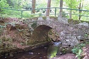
The bridge of the dead at Finsterbergen

Former sawmills in the Leinagrund north of Finsterbergen

A washing area in the local area of Engelsbach


- Lower course

the Wilde Leina in Schönau vdW
Wilde Leina on Gospiterodaer Str. In Leina

Leina, Altenwasser and Hörsel in Leina


literature
- Helga Raschke : About water workers, millers, tanners and flax farmers . Ed .: URANIA Kultur- und Bildungsverein Gotha eV Strölin Druck (Waltershausen), Gotha 2000, p. 58 .
Web links
Individual evidence
- ↑ Official topographic maps of Thuringia 1: 10,000. LK Schmalkalden-Meiningen, LK Hildburghausen, LK Sonneberg, district-free city of Suhl . In: Thuringian Land Survey Office (Hrsg.): CD-ROM series Top10 . CD 6. Erfurt 1999.
- ↑ Herbert Mehnert: On the trail of an old smelter at the Brandleiteteich near Finsterbergen . In: Kulturbund, Kreisverband Gotha (Hrsg.): Der Friedenstein . April issue. Gotha 1957, p. 61-62 .
- ↑ a b c Thuringian State Institute for the Environment (ed.): Area and waterway key figures (directory and map). Jena 1998. 26 pp.
- ↑ a b River lengths according to geopaths (kmz, 150 kB)
- ↑ Longitudinal section of the Leina / Hörsel ( Memento of the original from April 14, 2015 in the Internet Archive ) Info: The archive link was automatically inserted and not yet checked. Please check the original and archive link according to the instructions and then remove this notice. (TLUG Jena) - PDF, 66 kB
- ↑ Map services ( Memento of the original from December 19, 2012 in the Internet Archive ) Info: The archive link has been inserted automatically and has not yet been checked. Please check the original and archive link according to the instructions and then remove this notice. of the BfN
- ↑ To make it easier to sort, there are hyphens behind the 416 (= Hörsel).