
Lej da las Culuonnas
| Lej da las Culuonnas | ||
|---|---|---|

|
||
| Geographical location | Canton of Graubünden , Switzerland | |
| Drain | Ova dal Vallun → Inn → Danube | |
| Places on the shore | Julier Pass | |
| Location close to the shore | Silvaplana | |
| Data | ||
| Coordinates | 775 597 / 148 161 | |
|
||
| Altitude above sea level | 2270 m above sea level M. | |
| surface | 3.389 9 ha | |
| length | 260 m | |
| width | 225 m | |
| scope | 837 m | |

The Lej da las Culuonnas ( Rhaeto-Romanic in the idiom Puter lej from the Latin lacus for 'lake' and culuọnna for 'pillar') is a mountain lake at 2270 m above sea level. M. on the Julier Pass above Bivio and Silvaplana in the canton of Graubünden in the Swiss Alps . The lake takes its name from the fragments of a Roman column on the top of the pass.
Location and surroundings

The lake is located in the Albula Alps on the Julier Pass at the northern foot of the Piz da las Coluonnas . North of the pass are Chüern Nair and Piz Valletta , the Piz Julier is located northeast of the pass.
The lake is located entirely in the municipality of Silvaplana , the border with Surses runs along the watershed and is only 35 m north and east of the lake. The Lej da las Culuonnas thus drains eastwards via Ova dal Vallun → Inn → Danube into the Black Sea .
Origin of name

Culuọnna is Rhaeto-Romanic in the idiom Puter for 'column'. The lake got its name from the pillars that are erected on the nearby road , at the top of the Julier Pass. The column fragments were discovered during excavations on the Julier Pass; they belonged to a Roman sanctuary located on the top of the pass.
gallery

The Lej da las Culuonnas and the Juliertheater , taken from the southeast
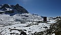
The Lej da las Culuonnas, the kiosk, the pass road and the Juliertheater, taken from the northwest


Web links
literature
- National map of Switzerland, sheet 1256 Bivio, 1: 25000, Federal Office of Topography, 2015 edition.
Individual evidence
- ↑ Andrea Schorta: How the mountain got its name . Small Rhaetian name book with two and a half thousand geographical names of Graubünden. Terra Grischuna Verlag, Chur and Bottmingen / Basel 1988, ISBN 3-7298-1047-2 , p. 98 .
- ↑ a b c Andrea Schorta: How the mountain got its name . Small Rhaetian name book with two and a half thousand geographical names of Graubünden. Terra Grischuna Verlag, Chur and Bottmingen / Basel 1988, ISBN 3-7298-1047-2 , p. 79 .