
Piz Polashin
| Piz Polashin | ||
|---|---|---|
 Crap da Sass Castle, Lej da Silvaplauna, Silvaplana and Piz Polaschin in the background |
||
| height | 3013 m above sea level M. | |
| location | Canton of Graubünden , Switzerland | |
| Mountains | Albula Alps | |
| Dominance | 2.03 km → Piz Lagrev | |
| Notch height | 215 m ↓ Crasta Tscheppa | |
| Coordinates | 777 854 / 148265 | |
|
||
| First ascent | October 1, 1849 | |
| Normal way | From the Julier Pass road over the southeast or south ridge | |
 Summit cross with Piz Güglia in the background |
||

The Piz Polashin ( Rhaeto-Romanic in the idiom Puter for Däumling ) is a mountain west of Silvaplana in the canton of Graubünden in Switzerland with an altitude of 3,013 m above sea level. M.
Location and surroundings

The Piz Polashin belongs to the Lagrev group, a subgroup of the Albula Alps . The municipal boundary between Silvaplana and Sils i. E. The Piz Polashin is bordered in the north by the Julierpassstrasse and in the south-east by the Upper Engadine .
The neighboring peaks include the Piz Lagrev and the Piz Julier .
Between the Piz Polashin and the Piz Lagrev is located at 2721 m above sea level. M. a mountain lake. Piz Polashin also has several lakes in the south, the largest of which is called Lej da la Tscheppa .
Valley locations are Silvaplana and Sils i. E. A frequent starting point is the Julierpassstrasse.
Routes to the summit
Over the southeast ridge (Chavagl dal Polashin)
- Starting point: Silvaplana ( 1815 m ) or from the Julier Pass road (Il Dschember, 2010 m )
- Via: Muttaun, Chavagl dal Polaschin ( 2830 m )
- Difficulty: L until Muttaun as trail white-red-white highlighted
- Time required: 3¾ hours from Silvaplana, 3 hours from the Julierpass road
Over the south ridge from the Julierpassstrasse
- Starting point: Julierpassstrasse (Cna dal Stradin, 2161 m )
- Via: Gianda Polashin, Gianda Lagrev, Fuorcla Polashin ( 2864 m )
- Difficulty: L
- Time required: 2½ hours
Over the south ridge via Lej da la Tscheppa
- Starting point: Sils-Baselgia ( 1799 m ), Silvaplana ( 1815 m ) or from the Julierpassstrasse (Il Dschember, 2010 m )
- Via: Lej da la Tscheppa ( 2864 m ), Fuorcla Polashin ( 2864 m )
- Difficulty: L until Lej da la Tscheppa as trail white-red-white marks
- Time required: 3¾ hours from Sils-Baselgia, 4 hours from Silvaplana or 3¼ hours from the Julierpass road (1 hour from Lej da la Tscheppa)
Over the north ridge
- Starting point: Julierpassstrasse (Cna dal Stradin, 2161 m )
- Difficulty: ZS , III
- Time required: 4 hours from Silvaplana
From the east to the north ridge
- Starting point: Silvaplana ( 1815 m ) or from the Julier Pass road (Il Dschember, 2010 m )
- Via: Muttaun, north slope
- Difficulty: ZS , III , BG- to the start
- Time required: 3 hours from Silvaplana, 2¼ hours from the Julierpass road to the entrance
panorama

gallery

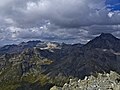
View over the Upper Engadine .

View of Silvaplana and Surlej.

View to the Julier Pass .

View to Piz Lagrev .
View towards NNW to the Julier and Bever groups and the Err area.

Lej da la Tscheppa 2616 m above sea level M. , taken from the Fuorcla Polashin.

Lake in Gianda Lagrev 2721 m above sea level M. , between Piz Lagrev and Piz Polashin, in the background the Piz Polashin.


literature
- Manfred Hunziker: Club Guide, Bündner Alpen, Volume VI (From Septimer to Flüela). 3. Edition. Verlag des SAC, 2000, ISBN 3-85902-187-7 , pp. 90-91.
- National map of Switzerland, sheet 1256 Bivio, 1: 25000, Federal Office of Topography, edition 2001.
- National map of Switzerland, sheet 1257 St. Moritz, 1: 25000, Federal Office of Topography, edition 2001.
Web links
- Panorama from Piz Polashin
- www.hikr.org Tour reports