
Piz Lagrev
| Piz Lagrev | ||
|---|---|---|
 Piz Lagrev above Lake Sils |
||
| height | 3165 m above sea level M. | |
| location | Canton of Graubünden , Switzerland | |
| Mountains | Albula Alps | |
| Dominance | 5.773 km → Piz Julier | |
| Notch height | 856 m ↓ Septimer pass | |
| Coordinates | 775 512 / 146 373 | |
|
||
| First ascent | R. Held with Moritz Arpagaus, October 9, 1875 | |
 The Piz Lagrev with the Leg Grevasalvas from the northwest, taken from the Piz Neir . |
||
 Summit cross on the Piz Lagrev. |
||

The Piz Lagrev (from pre-Roman grava 'gravel', Romansh grava 'river debris, fine scree in the mountains') is 3165 m above sea level. M. high mountain south of the Julier Pass in the Albula Alps in the Swiss canton of Graubünden . Due to the proximity to 2284 m above sea level. M. high Julier Pass, it is a popular, easy-to-reach ski touring mountain.
Location and surroundings

The Piz Lagrev belongs to the Lagrev group, a subgroup of the Albula Alps . It is the highest point of the mountain range between the Septimerpass in the southwest, the Julierpass in the north, the Upper Engadin in the southeast and the Oberhalbstein in the northwest. The village of Sils is located directly at the southeastern foot of the mountain , but when viewed from Maloja to the southwest, Piz Lagrev appears as an impressive rock formation. In addition to the extensive panorama from the summit in all directions, the deep view of Lake Sils is particularly remarkable. With a notch height of 856 meters, Piz Lagrev is a relatively independent mountain.
The municipality boundary runs above the summit between Surses in the northwest and Sils in the southeast. The border with Silvaplana is only 720 m northeast of the summit, at the lower summit of Piz Lagrev.
The neighboring peaks include Piz da las Coluonnas in the north, Piz Polashin in the northeast, and Piz d'Emmat Dadora , Piz d'Emmat Dadaint and Piz Materdell in the west. To the southwest of the summit is the Fuorcla Grevasalvas , in the northeast the Fuorcla Lagrev . In addition, Leg Grevasalvas and Lej Lagrev are close to the mountain.
The farthest visible point ( 44 ° 14 '3.6 " N , 7 ° 1' 23.8" O ) from Piz Lagrev is the Guglia di San Bernolfo ( 2600 m slm ) in the Italian province Cuneo ( Piedmont near) the border with the French region Provence-Alpes-Côte d'Azur and is 324 km away.
To the northeast of the north summit, the summit has a small glacier, the Vadret Lagrev .
Valley locations are Sils and Bivio . Frequent starting point is the Julier Pass.
Routes to the summit
Summer routes
From the north over the Vadret Lagrev
- Starting point: Chamanna dal Stradin ( 2161 m ) on the Julier Pass road
- Via: Gianda Polaschin, Lej Lagrev ( 2719 m ), Vadret Lagrev, Northeast Summit ( 3109 m )
- Difficulty: L
- Time required: 3½ hours
- Note: The Vadret Lagrev is harmless, but crampons are indispensable due to the fact that it is soaked up in midsummer and autumn.
From Lej da la Tscheppa over the Vadret Lagrev
- Starting point: Sils ( 1793 m ) or Silvaplana ( 1799 m )
- Via: Lej da la Tscheppa ( 2617 m ), P. 2797 at the southwest end of Crasta Tscheppa, Vadret Lagrev, northeast summit ( 3109 m )
- Difficulty: L until Lej da la Tscheppa as trail white-red-white marks
- Time required: 5 hours (2½ hours from Lej da la Tscheppa)
- Note: normal route in summer; Since it leads through a game rest zone, it may not be used from the beginning of December to the end of June. Crampons are essential because the glacier is feral in summer and autumn.
Through the southern hollow
- Starting point: Plaun da Lej ( 1798 m )
- Difficulty: L
- Time required: 4½ hours
- Alternative: from Plaun dal Crot along the Ova dal Crot
Over the southeast ridge of the south summit
- Starting point: Plaun da Lej ( 1798 m )
- Difficulty: ZS
- Time required: 5 hours
- Note: some nice climbing spots ( III and IV ), but has brittle rock elsewhere.
Through the south wall couloir
- Starting point: Plaun da Lej ( 1798 m )
- Difficulty: WS
- Time required: 4½ hours
- First ascent: Ludwig Norman-Neruda with Christian Klucker , August 15, 1889 on a variant; Hans Peter Cornelius , August 1911 on another.
- Note: Risk of falling rocks, hardly used, not advisable
Over the southwest ridge
- Starting point: La Veduta on the Julierpass road ( 2237 m ) or Plaun da Lej ( 1799 m )
- Via: Fuorcla Grevasalvas ( 2687 m ), southwest ridge, southern summit ( 3083 m )
- Difficulty: ZS until Fuorcla Grevasalvas as trail white-red-white highlighted
- Time required: 4 hours from La Veduta or 5½ hours from Plaun da Lej (2½ hours from Fuorcla Grevasalvas)
- First ascent: M. Finzi with Adolf Schaller and Josef Biner, August 31, 1921
- Note: More dangerous than difficult route
Through the gutter of the west wall
- Starting point: La Veduta on the Julierpass road ( 2237 m ) or Plaun da Lej ( 1799 m )
- Via: Fuorcla Grevasalvas ( 2687 m ), west wall channel
- Difficulty: ZS until Fuorcla Grevasalvas as trail white-red-white highlighted
- Time required: 4 hours from La Veduta or 5½ hours from Plaun da Lej (2½ hours from Fuorcla Grevasalvas)
- First ascent: By S. Gysperger and Christian Zuan, September 17, 1904
About the Fuorcla Lagrev
- Starting point: La Veduta on the Julier Pass road ( 2237 m )
- Via: Leg Grevasalvas ( 2390 m ), Fuorcla Lagrev ( 2863 m ), Vadret Lagrev, Northeast Summit ( 3109 m )
- Difficulty: BG until Leg Grevasalvas as trail white-red-white highlighted
- Time required: 3½ hours
Winter routes
The route from Silvaplana via Lej da la Tscheppa leads through a wildlife sanctuary and is therefore to be avoided.
From Alp Güglia
In winter only the north-east summit is mainly climbed.
- Starting point: Alp Güglia ( 2215 m ) on the Julier Pass road
- Via: Lej Lagrev ( 2719 m ), Vadret Lagrev to the north summit ( 3109 m )
- Exposures: N, NE
- Difficulty: ZS-
- Time required: 3 hours
- Note: the danger of avalanches in the lowest section must be observed (steep step up to 35 °)
panorama

gallery
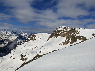
The main peak of Piz Lagrev, taken from the northeast peak.

In the middle of the picture the Piz Lagrev on a photo from 1925. The Vadret Lagrev runs down to the left, which is hardly there today and where the Lej Lagrev is today.

For comparison, a current photo of Piz Lagrev with Lej Lagrev and Vadret Lagrev, taken from Piz Polashin .

Lej Lagrev in Gianda Lagrev, with Piz Polashin in the background
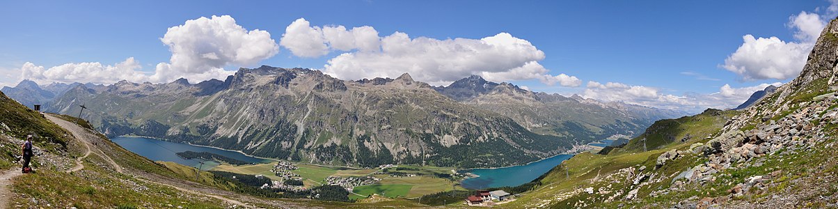
The Lagrev group, recorded by Furtschellas via Segl Maria .


literature
- Manfred Hunziker: Club guide, Bündner Alps . From the Septimer to the Flüela. 3. Edition. Vi. Verlag des SAC, 2000, ISBN 3-85902-187-7 , p. 80-86 .
- Vital Eggenberger: Ski tours Graubünden South . Verlag des SAC, 2010, ISBN 978-3-85902-301-7 , pp. 148 .
- National map of Switzerland, sheet 1256 Bivio, 1: 25,000, Federal Office of Topography, 2015 edition.
Web links
- Calculated 360 ° panorama from Piz Lagrev
- Tour reports on www.hikr.org
Individual evidence
- ↑ Andrea Schorta: How the mountain got its name . Small Rhaetian name book with two and a half thousand geographical names of Graubünden. Terra Grischuna Verlag, Chur and Bottmingen / Basel 1988, ISBN 3-7298-1047-2 , p. 96 .
- ↑ Calculated 360 ° panorama ( U. Deuschle ; information ) from Piz Lagrev