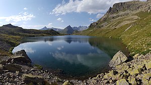
Leg Grevasalvas
| Leg Grevasalvas | ||
|---|---|---|

|
||
| Leg Grevasalvas, in the background Piz Neir (left) and Piz Bardella (center). | ||
| Geographical location | Canton of Graubünden , Switzerland | |
| Drain | Eva Cheda → Gelgia | |
| Location close to the shore | Bivio | |
| Data | ||
| Coordinates | 774 928 / 147556 | |
|
|
||
| Altitude above sea level | 2390 m above sea level M. | |
| surface | 7.364 3 ha | |
| length | 606 m | |
| width | 162 m | |
| scope | 1.43 km | |
| Catchment area | 4.1 km² | |
The Leg Grevasalvas ( Rhaeto-Romanic leg from the Latin lacus for 'lake' and Grevasalvas a composition of the Rhaeto-Romanic words greva for 'fine scree', ' scree slope ' and alv from the Latin albus for 'white') is a mountain lake at 2390 m above sea level. M. above Bivio near the Julier Pass in the municipality of Surses in the canton of Graubünden in the Swiss Alps .
Location and surroundings

The lake is located in the Albula Alps in the Grevasalvas basin , which is enclosed by the mountains Piz da las Coluonnas , Piz Lagrev , Piz d'Emmat Dadaint and Piz d'Emmat Dadora . The easiest access to the valley basin, which is located entirely within the municipality of Surses , comes from the Julierpassstrasse . Three passes lead out of the basin: The Fuorcla Lagrev , the Fuorcla Grevasalvas and the Fuorcla d'Emmat .
Access
Numerous routes of the surrounding peaks and passes lead past Leg Grevasalvas. In summer these are the routes to Piz d'Emmat Dadaint ( 2927 m ), Fuorcla d'Emmat ( 2756 m ), Piz d'Emmat Dadora ( 2851 m ), Fuorcla Grevasalvas ( 2688 m ), Piz Lagrev ( 3164 m ), to Fuorcla Lagrev ( 2863 m ) and Piz da las Coluonnas ( 2863 m ).
In winter, you can climb the Piz da las Coluonnas, Piz d'Emmat Dadora, Fuorcla d'Emmat, Piz d'Emmat Dadaint and, via Fuorcla Grevasalvas, Piz Grevasalvas ( 2863 m ) via the Leg Grevasalvas .
From La Veduta
- Starting point: La Veduta ( 2233 m ) on the Julier Pass road
- Route: Over the summit P. 2449
- Marked as a white-red-white hiking trail
- Difficulty: B
- Time required: ¾ hours
From Punt Brüscheda
- Starting point: P. 2081, above Punt Brüscheda on the Julier Pass road
- Marked as a white-red-white hiking trail
- Difficulty: B
- Time required: 1 hour
About the Fuorcla Grevasalvas
- Starting point: Plaun da Lej ( Sils in the Engadin , 1799 m )
- Route: Grevasalvas summer settlement ( 1941 m ), Plaun Grand, Fuorcla Grevasalvas ( 2687 m )
- Marked as a white-red-white hiking trail
- Difficulty: B
- Time required: 3¾ hours (¾ hours from Fuorcla Grevasalvas)
- Remarks: The middle section of the route shares with the national mountain hiking route Sils- Pass Lunghin - Bivio . Therefore, it can also be easily reached from other starting points between Maloja and Sils.
photos
Leg Grevasalvas from the north, in the background the Fuorcla Grevasalvas and the Piz d'Emmat Dadaint .
Web links
- www.hikr.org Various tour reports
literature
- National map of Switzerland, sheet 1256 Bivio, 1: 25000, Federal Office of Topography, 2015 edition
- Vital Eggenberger: Ski tours Graubünden South . Verlag des SAC, 2010, ISBN 978-3-85902-301-7 , pp. 150-158 .
- Manfred Hunziker: Club guide, Bündner Alps . From the Septimer to the Flüela. 3. Edition. Vi. Verlag des SAC, 2000, ISBN 3-85902-187-7 , p. 78-88 .
Individual evidence
- ↑ Andrea Schorta: How the mountain got its name . Small Rhaetian name book with two and a half thousand geographical names of Graubünden. Terra Grischuna Verlag, Chur and Bottmingen / Basel 1988, ISBN 3-7298-1047-2 , p. 98 .
- ↑ Andrea Schorta: How the mountain got its name . Small Rhaetian name book with two and a half thousand geographical names of Graubünden. Terra Grischuna Verlag, Chur and Bottmingen / Basel 1988, ISBN 3-7298-1047-2 , p. 93 .


