
Piz Neir
| Piz Neir | ||
|---|---|---|
 Crappa da Tocf and Piz Neir, taken from Marmels Castle |
||
| height | 2910 m above sea level M. | |
| location | Canton of Graubünden , Switzerland | |
| Mountains | Albula Alps | |
| Dominance | 2.1 km → Piz d'Agnel | |
| Notch height | 201 m ↓ Fuorcla digl Leget | |
| Coordinates | 772 098 / 150578 | |
|
||
 Steinmann on the Piz Neir |
||
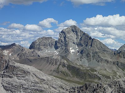
 Piz Neir, taken from Piz Barscheinz |
||
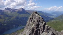
 Aerial view from Piz Neir |
||

The Piz Neir ( Rhaeto-Romanic in the idiom Surmiran for 'Black Summit') is a mountain west of the Julier Pass in the canton of Graubünden in Switzerland with a height of 2910 m above sea level. M.
Location and surroundings
The Piz Neir belongs to the Err area, a subgroup of the Albula Alps . It is located entirely in the municipality of Surses . North of the Piz Neir is the Val da Natons, otherwise the mountain is circled by the Oberhalbstein .
The neighboring peaks include the Crappa da Tocf , the Piz Campagnung and the Piz d'Agnel in the north, the Piz Bardella in the east and the Piz Barscheinz in the south.
The valley location is Bivio , frequent starting points are Bivio, Marmorera and the Julier Pass road .
Routes to the summit
Summer routes
Via the Piz Barscheinz
- Starting point: Bivio ( 1769 m ) or Bögia ( 1906 m ) on the Julier Pass road
- Via: Piz Barscheinz ( 2617 m )
- Difficulty: L
- Time required: 3½ hours from Bivio or 3 hours from Bögia
Over the southwest ridge
- Starting point: Bivio ( 1769 m )
- Via: Alp Barscheinz to the ridge that connects Piz Barscheinz with Piz Neir
- Difficulty: L
- Time required: 3 hours
- Alternative: head north and take the Bleis Muntaneala ( 2452 m ) with you.
Through the west flank
- Starting point: Marmorera ( 1700 m )
- Via: Alp Natons ( 1963 m ), southeast ridge, north ridge
- Difficulty: WS
- Time required: 3½ hours
Over the north ridge
- Starting point: Tigias ( 1975 m ), Marmorera ( 1700 m ) or the Val d'Agnel car park on the Julier Pass road ( 2200 m )
- Via: Fuorcla digl Leget ( 2711 m )
- Difficulty: WS
- Time required: 3 hours from Tigias, 3¾ hours from Marmorera or 2¾ hours from the Val d'Agnel car park
Over the east ridge
- Starting point: Punt Brüscheda ( 2043 m ) on the Julier Pass road
- Via: Vairana, P. 2576
- Difficulty: L
- Time required: 2½ hours
Winter routes
The Piz Neir itself is not a ski touring mountain. The pre-summits Crappa da Tocf ( 1769 m ), Bleis Muntaneala ( 2452 m ) and Piz Barscheinz ( 2617 m ) are often climbed in winter.
Bleis Muntaneala
- Starting point: Bivio ( 1769 m )
- Via: Plaz
- Exposures: SW
- Difficulty: L +
- Time required: 2 hours
- Alternative: In spring, if the conditions are safe, you can climb to Piz Barscheinz ( 2617 m ) (+ ½ hour).
- Note: Please note the Craps protected area!
Crappa da Tocf
- Starting point: Val d'Agnel car park on the Julierpass road ( 2200 m )
- Via: Through the Val d'Agnel to the plain at 2424 m , then turn left to Fuorcla digl Leget ( 2715 m ).
- Exposures: SE, NE
- Difficulty: L
- Time required: 2 hours
Descent through the Val da Natons
Occasionally used as an ascent.
- Destination: Marmorera ( 1720 m ) or Bivio ( 1766 m )
- Via: Fuorcla digl Leget, Alp Natons
- Exposures: N, W
- Difficulty: WS
panorama

gallery

Piz Neir, recorded by Riom .

Looking north to the Bergüner Stöcken with Piz Mitgel , Pizza Grossa and Tinzenhorn .

View to Piz d'Err , Piz Calderas , Tschima da Flix and Piz d'Agnel .
Looking east to Piz Julier .

View to the southeast to Piz Lagrev .

Looking west to Piz Platta .

View down to the Lai da Marmorera .
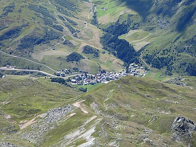
Looking down to Bivio .

View over Surgôt, the upper part of Surses .


literature
- Manfred Hunziker: Club guide, Bündner Alps . From the Septimer to the Flüela. 3. Edition. Vi. Verlag des SAC, 2000, ISBN 3-85902-187-7 , p. 160-161 .
- Vital Eggenberger: Ski tours Graubünden South . Verlag des SAC, 2010, ISBN 978-3-85902-301-7 , pp. 141 .
- National map of Switzerland, sheet 1256 Bivio, 1: 25,000, Federal Office of Topography, 2009 edition.
Web links
Individual evidence
- ↑ Andrea Schorta: How the mountain got its name . Small Rhaetian name book with two and a half thousand geographical names of Graubünden. Terra Grischuna Verlag, Chur and Bottmingen / Basel 1988, ISBN 3-7298-1047-2 , p. 109 .