
Piz Campaign
| Piz Campaign | ||
|---|---|---|
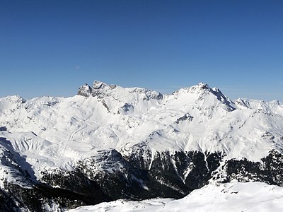
 Piz Campagnung (center), taken from the Val da Natons |
||
| height | 2826 m above sea level M. | |
| location | Canton of Graubünden , Switzerland | |
| Mountains | Albula Alps | |
| Dominance | 0.325 km → Piz d'Agnel | |
| Notch height | 43 m ↓ 175 m east of the summit | |
| Coordinates | 773 143 / 151825 | |
|
||
| rock | Greenish granite | |
| Normal way | Through the Val d'Agnel | |
 Summit of Piz Campagnung |
||
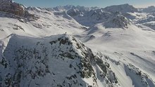
 Aerial view from Piz Campagnung |
||

The Piz Campagnung (enlargement from Rhaeto-Romanic in the idiom Surmiran campagna for field , field ) is a mountain east of Marmorera in the canton of Graubünden in Switzerland with a height of 2826 m above sea level. M. Towards the southeast it is inconspicuous and gently rising, from the other side it is rocky and steep. Its proximity to the Julier Pass makes it a popular, easy-to-reach ski touring mountain.
Location and surroundings
The Piz Campagnung belongs to the Err group , a subgroup of the Albula Alps . The municipal boundary between Marmorera and Bivio , which today both belong to Surses , ran above the summit . The Piz Campagnung is bordered in the west by the Val da Natons (a side valley of the Oberhalbstein ) and in the east by the Val d'Agnel.
The neighboring peaks include the Piz d'Agnel in the north, the Piz Surgonda in the northeast, the Corn Alv in the east, the Piz Bardella in the southeast and the Piz Neir and the Crappa da Tocf in the southwest.
South of Piz Campagnung there is a small mountain lake at 2691 m , the Leget Piz Campagnung .
Valley locations are Marmorera and Bivio. A frequent starting point is the Julierpassstrasse .
Routes to the summit
Summer routes
Through the Val d'Agnel
- Starting point: car park below La Veduta on the Julier Pass road ( 2200 m )
- Via: Through the Val d'Agnel on the hut path to Chamanna Jenatsch to the level at 2530 m , then turn left to Fuorcla digl Leget ( 2715 m ). Now west past the Schuttgkegel (P. 2752) and on a free route to the ridge.
- Difficulty level: EB (up to Fuoarcla digl Leget marked as a white-red-white hiking trail )
- Time required: 2½ hours (25 min from the Fuorcla digl Leget)
Through the Val da Natons
- Starting point: Marmorera ( 1720 m ), Marmorerasee ( 1680 m ), Stalveder ( 1713 m ) or Bivio ( 1766 m )
- Via: Alp Natons 1963 m to Fuorcla digl Leget ( 2715 m ). Now west past the Schuttgkegel (P. 2752) and on a free route to the ridge.
- Difficulty level: EB (up to Fuoarcla digl Leget marked as a white-red-white hiking trail )
- Time required: 3½ hours from Marmorera, 3¾ hours from Marmorera lake, 3½ hours from Stalveder or 3¾ hours from Bivio (25 min from Fuorcla digl Leget)
Over the cannon saddle
- Starting point: Sur ( 1537 m ) or Saltegnas on Alp Flix ( 1976 m )
- Via: Kanonensattel 2242 m to Fuorcla digl Leget ( 2715 m ). Now west past the Schuttgkegel (P. 2752) and on a free route to the ridge.
- Difficulty level: EB (up to Fuoarcla digl Leget marked as a white-red-white hiking trail )
- Time required: 4 hours from Sur or 2¾ hours from Saltegnas (25 min from Fuorcla digl Leget)
Winter routes
Instead of the Piz Campagnung, the 175 m higher P. 3001 north of the Piz Campagnung is often climbed.
From the Julierpassstrasse
- Starting point: car park below La Veduta on the Julier Pass road ( 2200 m )
- Via: Through the Val d'Agnel to the level at 2530 m , then turn left and straight to Piz Campagnung.
- Exposures: SE
- Difficulty: WS-
- Time required: 2 hours (2½ hours to P. 3001)
Descent through the Val da Natons
Occasionally used as an ascent.
- Destination: Marmorera ( 1720 m ) or Bivio ( 1766 m )
- Via: Fuorcla digl Leget, Alp Natons
- Exposures: N, W
- Difficulty: WS
- Alternative: Instead of using the Fuorcla digl Leget, you can also drive over the P. 2783 saddle into the Val da Natons.
panorama

gallery

Aerial view from Piz Campagnung. Towards the southeast (right) it is inconspicuous and gentle, from the other sides it is rocky and steep.

Looking east to Corn Alv (front) and Piz Julier (back).

View to the southeast to the Bernina group .

Looking west to Piz Platta .
View to the northwest to Piz Forbesch and Piz Arblatsch .


literature
- Manfred Hunziker: Club Guide, Bündner Alpen, Volume VI (From Septimer to Flüela). 3. Edition. Verlag des SAC, 2000, ISBN 3-85902-187-7 , p. 163.
- Vital Eggenberger: Ski tours Graubünden South. Verlag des SAC, 2010, ISBN 978-3-85902-301-7 , pp. 140-141.
- National map of Switzerland, sheet 1256 Bivio, 1: 25000, Federal Office of Topography, 2011 edition.
- National map of Switzerland, sheet 268S Julierpass, 1: 50000, Federal Office of Topography, 2011 edition.