
Piz Surgonda
| Piz Surgonda | ||
|---|---|---|
 Piz Surgonda, taken from Piz Neir . West summit ( 3193 m ) on the far left and east summit ( 3196 m ) on the right. |
||
| height | 3196 m above sea level M. | |
| location | Canton of Graubünden , Switzerland | |
| Mountains | Albula Alps | |
| Dominance | 1.75 km → Piz d'Agnel | |
| Notch height | 213 m ↓ Fuorcla d'Agnel | |
| Coordinates | 775 456 / 153 543 | |
|
||
| Normal way | Through the southern flank | |
 Aerial view from the east summit (south side) |
||
 Aerial view from the east summit (northeast slope) |
||
,_aerial_photography.jpg) Aerial view from the west summit |
||

The Piz Surgonda ( Rhaeto-Romanic sur for 'over' and gonda for ' scree / scree') is a mountain north of the Julier Pass in the canton of Graubünden in Switzerland . A rubble and craggy crest forms the higher east summit ( 3196 m above sea level ) and a rocky ridge with two neighboring elevations of the same height forms the west summit 400 m away ( 3193 m above sea level ). Because of the view it is a popular ski touring mountain.
Location and surroundings

The Piz Surgonda belongs to the Güglia and Bever group , a subgroup of the Albula Alps . The municipal boundary between Surses and Bever runs over the ridge . The municipal boundary to Silvaplana is at the pre-summit ( 3160 m above sea level ), 322 m southeast of the east summit. The Piz Surgonda is bordered in the south by the Val d'Agnel and in the north by the Val Bever.
The neighboring peaks include Piz Traunter Ovas in the north, Corn Suvretta in the east, Piz Julier in the south-east, Piz Valletta and Corn Alv in the south, Piz Bardella and Piz Campagnung in the south-west, Piz d'Agnel in the west and Tschima da Flix and Piz Picuogl in the northwest.
On the northern flank, the Piz Surgonda has a glacier, the Vadret Traunter Ovas .
Talort is Bivio. Frequent starting points are the Julier Pass and the Chamanna Jenatsch .
Routes to the summit
Summer routes
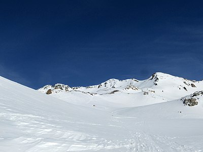
Through the southern flank
.jpg)
- Starting point: Parking (below La Veduta on the Julier Pass 2200 m , 774898 / one hundred and forty-nine thousand two hundred fifty-six )
- Via: Briefly follow the marked mountain path through the Val d'Agnel, then turn north-east through the valley between Corn Alv and Muot Cotschen. At approx. 2700 m (before Fuorcla Alva) turn northwest and over the wide rubble to the east summit.
- Difficulty: EB
- Time required: 3 hours
- Alternative 1: On the hut path to Chamanna Jenatsch through the Val d'Agnel up to approx. 2700 m , then over the southern flank
- Alternative 2: From Alp Güglia ( 2215 m ), through Valletta digl Güglia to Fuorcla Alva
Over the west ridge
- Starting point: car park below La Veduta on the Julierpassstrasse ( 2200 m ), Chamanna Jenatsch ( 2652 m ) or Spinas ( 1816 m )
- Via: Fuorcla d'Agnel ( 2983 m )
- Difficulty: L until d'Fuorcla Agnel as trail red-white-white highlighted
- Time required: 3½ hours from the Julierpassstrasse, 2¼ hours from the Chamanna Jenatsch or 5¼ hours from Spinas (from the Fuorcla d'Agnel ½ hour to the western summit and another half an hour to the eastern summit)
About the Fuorcla Traunter Ovas
- Starting point: Chamanna Jenatsch ( 2652 m ) or Spinas ( 1816 m )
- Via: Marked path to Fuorcla d'Agnel to the glacier lake ( 2766 m ), then east and gradually south to the depression of the summit ridge.
- Difficulty: L
- Time required: 2 hours from Chamanna Jenatsch or 5 hours from Spinas
- Comment: Glacier inspection
Over the southeast ridge
- Starting point: car park below La Veduta on the Julierpassstrasse ( 2200 m ) or Alp Güglia ( 2215 m )
- Via: Fuorcla Margun ( 2945 m )
- Difficulty: WS
- Time required: 3¾ hours (1¼ from Fuorcla Margun)
Winter routes
From the Chamanna Jenatsch

- Starting point: Chamanna Jenatsch ( 2652 m )
- Via: Direction Fuorcla d'Agnel, Fuorcla Traunter Ovas
- Exposures: E, NW
- Difficulty: WS
- Time required: 2 hours
- Descent: Alternatively, you can also descend into Val Bever (counterclockwise around Piz Traunter Ovas).
From Alp Güglia
- Starting point: Alp Güglia ( 2215 m )
- Via: Valletta dal Güglia, Fuorcla Alva, south-west past the pre-summit ( 3160 m )
- Exposures: S, E, W
- Difficulty: WS-
- Time required: 3½ hours
From La Veduta
- Starting point: car park below La Veduta on the Julier Pass road ( 2200 m )
- Via: To the N over the ridge, through the valley between Corn Alv and Muot Cotschen, to Fuorcla Alva, southwest of the pre-summit ( 3160 m )
- Exposures: S
- Difficulty: WS-
- Time required: 3½ hours
- Alternative: On the hut path to Chamanna Jenatsch through the Val d'Agnel up to approx. 2700 m , then to P. 2912
panorama

gallery
Piz Surgonda, taken from the Fuorcla Alva.

Piz Surgonda (front) and Piz Julier (back), taken from the Tschima da Flix .

View from the east summit to the west summit.

View to the northwest to Tschima da Flix , Piz Picuogl , Piz Calderas , Piz d'Err , Haldensteiner Calanda , Tinzenhorn , Aroser Rothorn , Piz Jenatsch and Piz Ela (from left to right).

View to the northeast to Piz Kesch .

View to the southeast to Piz Julier (front) and Piz Bernina (back).


literature
- Manfred Hunziker: Club Guide, Bündner Alpen, Volume VI (From Septimer to Flüela). 3. Edition. Verlag des SAC, 2000, ISBN 3-85902-187-7 , pp. 152-154.
- Vital Eggenberger: Ski tours Graubünden South. Verlag des SAC, 2010, ISBN 978-3-85902-301-7 , pp. 142-144.
- National map of Switzerland, sheet 1256 Bivio, 1: 25000, Federal Office of Topography, 2011 edition.