Piz Bardella
| Piz Bardella | ||
|---|---|---|
|
Piz Bardella, taken from the car park below La Veduta ( Julierpass road ) |
||
| height | 2839 m above sea level M. | |
| location | Canton of Graubünden , Switzerland | |
| Mountains | Albula Alps | |
| Dominance | 1.36 km → Corn Alv | |
| Notch height | 191 m ↓ Below the Fourcla digl Leget | |
| Coordinates | 773.85 thousand / 150 395 | |
|
|
||
| rock | lime | |
|
Piz Bardella, taken from the north (below the Fuorcla digl Leget) |
||
The Piz Bardella is a mountain northwest of the Julier Pass in the canton of Graubünden in Switzerland with an altitude of 2839 m above sea level. M. He is an elongated, narrow in the summit area, exposed, running in a north-south direction ridge. The name could saddle Bardella arise. The Bardella, also called Maremmana , is the saddle of the Butteri , the cattle herders of Tuscany .
Location and surroundings
The Piz Bardella belongs to the Err area, a subgroup of the Albula Alps . The mountain is located entirely within the municipality of Surses . The Piz Bardella is bordered to the east by the Val d'Agnel and to the west by the Vairana basin.
The neighboring peaks include the Piz Neir , the Piz Campagnung , the Corn Alv and the Piz Valetta .
Talort is Bivio. A frequent starting point is the Val d'Agnel car park at the road bend below La Veduta on the Julier Pass road .
Wind station

On the summit of Piz Bardella is one of 160 wind stations of the Intercantonal Measurement and Information System (IMIS) . The system is operated in cooperation with the federal government, cantons, municipalities, the WSL Institute for Snow and Avalanche Research SLF and other interest groups. The associated snow station is located in the Vairana hollow, southwest of Piz Bardella, at 2,430 m above sea level. M. The station measures wind half-hourly wind speed (mean and peak), wind direction, air temperature and relative humidity. The avalanche warning service and safety officers throughout Switzerland are thus provided with the latest information from remote and / or inaccessible areas. The data can be viewed on the SLF website.
Routes to the summit
Over the south ridge
Over the north ridgeEasily accessible to the north summit. According to the guide, the exposed ridge between the north and main peaks is for people who appreciate adventurous climbing.
|
panorama
gallery
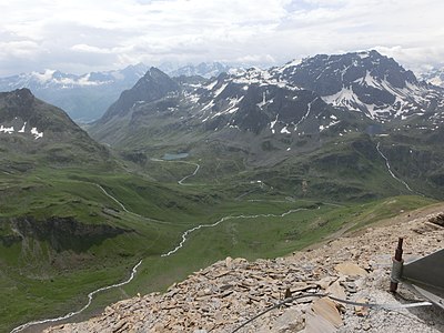
View from Piz Bardella to the west to Piz Neir and Crappa da Tocf . In the background the Piz Platta and the Piz Forbesch .
View of the Julier Pass and Piz Polashin . Even further in the background the Bernina group .
literature
- Eugen Wenzel, Paul Gross: Club Guide, Graubünden Alps, Volume VI (Albula). 2nd Edition. Verlag des SAC, 1980, ISBN 3-85902-012-9 , p. 97.
- Manfred Hunziker: Club Guide, Bündner Alpen, Volume VI (From Septimer to Flüela). 3. Edition. Verlag des SAC, 2000, ISBN 3-85902-187-7 , pp. 161-162.
- National map of Switzerland, sheet 1256 Bivio, 1: 25000, Federal Office of Topography, edition 2001.
Web links
Individual evidence
- ↑ IMIS - Intercantonal Measurement and Information System ( Memento of the original dated August 13, 2017 in the Internet Archive ) Info: The archive link was inserted automatically and has not yet been checked. Please check the original and archive link according to the instructions and then remove this notice. . Website of the WSL Institute for Snow and Avalanche Research. Retrieved July 21, 2014.
- ↑ SLF> Snow info> Measured values> Wind and temperature data> North and Central Grisons ( Memento of the original from July 14, 2014 in the Internet Archive ) Info: The archive link was automatically inserted and not yet checked. Please check the original and archive link according to the instructions and then remove this notice. . Website of the WSL Institute for Snow and Avalanche Research. Retrieved July 21, 2014.


