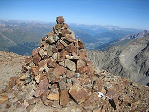
Tschima da Flix
| Tschima da Flix | ||
|---|---|---|
|
Tschima da Flix, recorded from Piz Calderas |
||
| height | 3316 m above sea level M. | |
| location | Canton of Graubünden , Switzerland | |
| Mountains | Albula Alps | |
| Dominance | 0.22 km → Piz Picuogl | |
| Notch height | 34 m ↓ Piz Picuogl | |
| Coordinates | 773 457 / 154.77 thousand | |
|
|
||
|
Stone men on the Tschima da Flix |
||
The Tschima da Flix is a mountain east of Sur in the canton of Graubünden in Switzerland with an altitude of 3301 m above sea level. M. As it is relatively easy to reach and offers rewarding descents, it is a popular ski touring mountain.
Location and surroundings
The Tschima da Flix belongs to the calderas group in the Err area , which in turn belongs to the Albula Alps . The municipal boundary between Surses and Bever runs over the summit . The Tschima da Flix is bordered in the east by the Val Bever and in the west by the Oberhalbstein .
The neighboring peaks include the Piz Calderas in the north, the Piz Picuogl in the west, the Piz Surgonda and Piz d'Agnel in the south and the Piz Cucarnegl in the northwest.
On the northern flank, the Tschima da Flix has a glacier, the Vadret Calderas .
Valley locations are Sur and Bever. Frequent starting points are the Jenatschhütte , the Julierpass and the Alp Flix .
Origin of name
Tschima ( Puter ) or Tschema ( Surmeirisch ) means mountain peak or treetop and comes from the Greek word cyma for cabbage sprout , tip , peak .
The word flix probably comes from the Latin fluxus for flowing .
Routes to the summit
Summer routes
Over the Vadret Calderas
- Starting point: Jenatschhütte ( 2652 m )
- Difficulty: L
- Time required: 2 hours
- Comment: Glacier inspection
Over the south ridge
- Starting point: Jenatschhütte ( 2652 m ), Alp Flix (Salategnas, 1976 m ) or Julierpass ( 2284 m )
- Via: Fuorcla da Flix ( 3064 m )
- Difficulty: L, to Fuorcla da Flix marked as a white-red-white hiking trail
- Time required: 2¼ hours from the Jenatschhütte, 3¾ hours from Alp Flix or 4½ hours from the Julier Pass
Through the west wall
Winter routes
Over the Vadret Calderas
- Starting point: Jenatschhütte ( 2652 m )
- Exposures: N, NE
- Difficulty: WS
- Time required: 2 hours
About the Fuorcla da Flix
- Starting point: Jenatschhütte ( 2652 m ) or Julierpass ( 2284 m )
- Via: (Fuorcla d'Agnel), Fuorcla da Flix
- Exposures: E, S
- Difficulty: WS +
- Time required: 2 hours from the Jenatschhütte, 3¾ hours from the Julier Pass
Departure to Bivio or Marmorera
- Destination: Bivio ( 1769 m ) or Marmorera ( 1708 m )
- Via: Fuorcla da Flix, Val da Natons
- Exposures: SW
- Difficulty: ZS
Departure to Sur via Fuorcla da Flix
- End: Sur ( 1617 m )
- Via: Fuorcla da Flix, Val Savriez, Saltegnas (Alp Flix), Tigias (Alp Flix)
- Exposures: W
- Difficulty: ZS
Departure to Sur via Vadret Calderas
- End: Sur ( 1617 m )
- Via: Vadret Calderas, W-Rinne, Plang Lung, Tigias (Alp Flix)
- Exposures: N, W
- Difficulty: ZS +
- Note: The channel is up to 40 ° steep at the top
panorama
gallery
The Err area, recorded by Riom-Parsonz .
View of the Piz Calderas .
View of the Piz d'Agnel .
View of the Piz Picuogl .
View of Piz Surgonda , Piz Güglia and the Bernina group
literature
- Eugen Wenzel, Paul Gross: Club Guide, Graubünden Alps, Volume VI (Albula). 2nd Edition. Verlag des SAC, 1980, ISBN 3-85902-012-9 , pp. 88-90.
- Vital Eggenberger: Ski tours Graubünden South. Verlag des SAC, 2010, ISBN 978-3-85902-301-7 , pp. 137-138.
- National map of Switzerland, sheet 1256 Bivio, 1: 25,000. Federal Office for Topography, 2009 edition.
- National map of Switzerland, sheet 268S Julierpass, 1: 50,000, Federal Office of Topography, 2012 edition.
Web links
- Panorama from the Tschima da Flix
- www.hikr.org Tour reports
Individual evidence
- ↑ Andrea Schorta: How the mountain got its name. Small Rhaetian name book with two and a half thousand geographical names of Graubünden . Terra Grischuna Verlag, Chur / Bottmingen / Basel 1988, ISBN 3-7298-1047-2 , p. 144 .
- ↑ Andrea Schorta: How the mountain got its name. Small Rhaetian name book with two and a half thousand geographical names of Graubünden . Terra Grischuna Verlag, Chur / Bottmingen / Basel 1988, ISBN 3-7298-1047-2 , p. 87 .


