
Piz d'Emmat Dadaint
| Piz d'Emmat Dadaint | ||
|---|---|---|
 Fuorcla Grevasalvas , Piz d'Emmat Dadaint, Fuorcla d'Emmat and Piz d'Emmat Dadora (from left) |
||
| height | 2928 m above sea level M. | |
| location | Canton of Graubünden , Switzerland | |
| Mountains | Albula Alps | |
| Dominance | 0.96 km → Piz Materdell | |
| Notch height | 149 m ↓ Fuorcla Materdell | |
| Coordinates | 774 036 / 145 804 | |
|
||
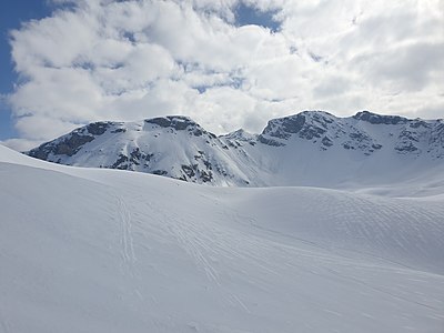
| Normal way | About Leg Grevasalvas | |
 Leg Grevasalvas , in the background Piz Lagrev , Piz d'Emmat Dadaint and Piz d'Emmat Dadora |
||

The Piz d'Emmat Dadaint is a mountain southwest of the Julier Pass and northwest of Lake Sils in the canton of Graubünden in Switzerland with an altitude of 2928 m above sea level. M. Being close to the Julier Pass, he is a popular, easy-to-reach mountain ski tours.
Location and surroundings

The Piz d'Emmat Dadaint belongs to the Piz Lagrev group , a subgroup of the Albula Alps . The Piz d'Emmat Dadaint separates the Oberhalbstein from the Engadine . The main peak is in the area of the municipality of Surses , immediately south of the highest point is the border with the municipality of Sils in the Engadin / Segl . Via the Fuorcla d'Emmat ( 2755 m ) the mountain is connected to the Piz d'Emmat Dadora ( 2850 m ).
The neighboring peaks of Piz d'Emmat Dadaint include the Piz Materdell ( 2966 m ) in the southwest, the Roccabella ( 2730 m ) in the west, the Piz d'Emmat Dadora in the north as well as the Piz da las Coluonnas ( 2802 m ) and the Piz Lagrev ( 3165 m ) in the northeast.
Frequent starting points for climbing Piz d'Emmat Dadaint are La Veduta ( 2237 m ) and Plaun da Lej in the Upper Engadin ( 1798 m ).
The farthest visible point from Piz d'Emmat Dadaint is the Bietschhorn in the west and is 142 km away. The 3934 m above sea level. Along with the Aletschhorn, M. Hohe Bietschhorn is one of the most striking peaks in the southern part of the Bernese Alps , part of the Swiss canton of Valais .
Origin of name
Emmat (Demat) is probably derived from the Romansh gliemat, emat for 'floor beam, threshold'. A derivation from the Latin intimus for 'innermost' is possible, but less certain . In the idiom Surmiran, Dadaint stands for 'inner, within' and is derived from the Latin deintus .
Routes to the summit
Summer routes
About the Leg Grevasalvas


- Starting point: La Veduta ( 2237 m ) on the Julier Pass road
- Via: Leg Grevasalvas
- Difficulty: L until Fuorcla Grevasalvas as trail white-red-white highlighted
- Time required: 4 hours
- Comment: As far as the scree basin below the Fuorcla Grevasalvas, then west over the scree slopes to the east ridge. Over the ridge to the summit.
From the south
- Starting point: Plaun da Lej ( 1798 m )
- Via: Plaun Grand
- Difficulty: L
- Time required: 3½ to 4 hours
- Note: Up above P. 2576, then over steep scree slopes to the summit.
Over the south-west ridge
- Starting point: Plaun da Lej ( 1798 m )
- Via: Plaun Grand, Fuorcla Materdell ( 2779 m )
- Difficulty: L
- Time required: 3½ to 4 hours
Winter routes
About the Leg Grevasalvas
- Starting point: La Veduta ( 2237 m )
- Via: Leg Grevasalvas, Fuorcla Grevasalvas
- Exposures: N, NE
- Difficulty: WS +
- Time required: 2½ hours
From Plaun da Lej
- Starting point: Plaun da Lej ( 1798 m )
- Via: Plaun Grand
- Exposures: S, SE
- Difficulty: ZS-
- Time required: 3½ hours
panorama

gallery

Piz d'Emmat Dadaint, viewed from the northeast.

Lake Sils , in the background Piz Materdell , Piz d'Emmat Dadaint and Piz Lagrev (from left).
Piz d'Emmat Dadora, Fuorcla d'Emmat , Piz d'Emmat Dadaint (from left) and Piz Lagrev (back), taken by Bocchetta d'Emmat


literature
- Manfred Hunziker: Club guide, Bündner Alps . Obverse. 1st edition. tape VI . Verlag des SAC, 1994, ISBN 3-85902-140-0 , p. 37 .
- Vital Eggenberger: Ski tours Graubünden South . Verlag des SAC, 2010, ISBN 978-3-85902-301-7 , pp. 154-156 .
- National map of Switzerland, sheet 1276 Val Bregaglia, 1: 25,000, Federal Office of Topography, edition 2001.
Web links
- Calculated 360 ° panorama of Piz d'Emmat Dadaint
- Tour reports on www.hikr.org
Individual evidence
- ↑ Calculated 360 ° panorama ( U. Deuschle ; information ) from Piz d'Emmat Dadaint
- ↑ Andrea Schorta: How the mountain got its name . Small Rhaetian name book with two and a half thousand geographical names of Graubünden. Terra Grischuna Verlag, Chur and Bottmingen / Basel 1988, ISBN 3-7298-1047-2 , p. 85 .
- ↑ Andrea Schorta: How the mountain got its name . Small Rhaetian name book with two and a half thousand geographical names of Graubünden. Terra Grischuna Verlag, Chur and Bottmingen / Basel 1988, ISBN 3-7298-1047-2 , p. 82 .