
Roccabella
| Roccabella | ||
|---|---|---|
 Roccabella by Bivio |
||
| height | 2730 m above sea level M. | |
| location | Canton of Graubünden , Switzerland | |
| Mountains | Albula Alps | |
| Dominance | 1.15 km → Piz d'Emmat Dadora | |
| Notch height | 231 m ↓ Bocchetta d'Emmat | |
| Coordinates | 772312 / 146 475 | |
|
||
| Normal way | Over the southern slope | |
 Roccabella as seen from Tua |
||

The Roccabella (from the Italian rocca for 'rock') is a mountain southeast of Bivio in the canton of Graubünden in Switzerland at an altitude of 2730 m above sea level. M. It offers a beautiful view and is often visited on skis.
Location and surroundings

The Roccabella belongs to the Piz Lagrev group, a subgroup of the Albula Alps . The mountain is entirely within the municipality of Surses . The Roccabella is bordered in the north by the main valley of the Oberhalbstein , in the west by the Tgavretga and in the south by the high valley Emmat.
The neighboring peaks include Piz Barscheinz and Piz Neir in the north, Piz Grevasalvas in the south and Piz Materdell , Piz d'Emmat Dadaint and Piz d'Emmat Dadora in the east. The Bocchetta d'Emmat connects the Roccabella with the Piz Materdell.
The most distant visible point ( 47 ° 14 ′ 57.9 ″ N , 9 ° 20 ′ 35.5 ″ E ) from the Roccabella is the Säntis on the border between the cantons of St. Gallen , Appenzell Innerrhoden and Appenzell Ausserrhoden and is 92.8 km away.
Talorte is Bivio .
Routes to the summit
Summer routes
Over the southern slope
- Starting point: Bivio ( 1769 m )
- Via: Septimerweg, Cadval, Bocchetta d'Emmat
- Difficulty: B than trail white-red-white marks
- Time required: 2½ – 3 hours
Over the north slope
- Starting point: Mot ( 1879 m ) on Julierstrasse
- Via: Alac
- Difficulty: EB
- Time required: 2½ hours
Winter routes

From Bivio
- Starting point: Bivio ( 1769 m )
- Via: Tgavretga, Fumia, Mulde Emmat, Bocchetta d'Emmat
- Exposures: S, W
- Difficulty: WS-
- Time required: 2½ hours
Descent over the north flank
Racy steep descent, which requires perfect conditions (35–40 ° on 450 m). The descent route is clearly visible from the Julierpassstrasse.
panorama

gallery

North side of the Roccabella.

The southern slope of the Roccabella.

Skiers on the north slope of the Roccabella.

The Roccabella, taken from Piz Grevasalvas .
View of the Julier Pass , behind the Piz Julier .

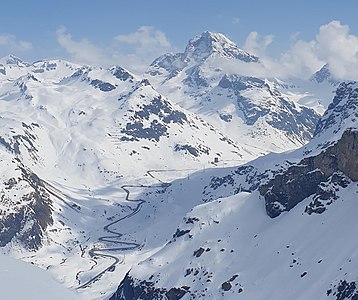
View down into Oberhalbstein


literature
- Eugen Wenzel, Paul Gross: club guide, Bündner Alps . Albula. 2nd Edition. tape VI . Verlag des SAC, 1980, ISBN 3-85902-012-9 , p. 37 .
- Vital Eggenberger: Ski tours Graubünden South . Verlag des SAC, 2010, ISBN 978-3-85902-301-7 , pp. 161 .
- National map of Switzerland, sheet 1256 Bivio, 1: 25,000, Federal Office of Topography, 2015 edition.
Web links
- Calculated 360 ° panorama from the Roccabella
- Tour reports on www.hikr.org
Individual evidence
- ↑ Andrea Schorta: How the mountain got its name . Small Rhaetian name book with two and a half thousand geographical names of Graubünden. Terra Grischuna Verlag, Chur and Bottmingen / Basel 1988, ISBN 3-7298-1047-2 , p. 122 .
- ↑ Calculated 360 ° panorama ( U. Deuschle ; information ) from the Roccabella