
Lej da la Tscheppa
| Lej da la Tscheppa | ||
|---|---|---|

|
||
| Geographical location | Canton of Graubünden , Switzerland | |
| Drain | Ova da la Tscheppa → Inn | |
| Location close to the shore | Sils in the Engadin / Segl | |
| Data | ||
| Coordinates | 777 682 / 147020 | |
|
||
| Altitude above sea level | 2617 m above sea level M. | |
| surface | 7,908 2 ha | |
| length | 385 m | |
| width | 278 m | |
| scope | 1.15 km | |
| Catchment area | 1.36 km² | |

|
||
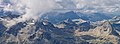
| Lej da la Tscheppa from the north, in the background v. l. No. Piz Boval , Piz Tschierva , Piz Morteratsch , Piz Palü , Piz Prievlus , Piz Bernina , Piz Murtel , Piz Corvatsch , Piz Glüschaint and Il Chapütschin . | ||

The Lej da la Tscheppa ( Rhaeto-Romanic lej from the Latin lacus for 'lake' and Tscheppa 'undergrowth' in Latin cippus , boundary stone, pile ') is a mountain lake at 2617 m above sea level. M. above Sils in the Engadin in the canton of Graubünden in the Swiss Alps .
Location and surroundings

The lake is located in the Albula Alps in the La Tscheppa valley basin , which is bordered by the Crutscharöl ridge in the southwest, the Crasta Tscheppa ridge section in the northwest, Piz Polashin in the north, and the Chavagl dal Polashin in the northeast. There are other smaller lakes in the basin. The easiest access to the lake, which is located entirely within the municipality of Sils in the Engadin , comes from Sils Maria, Sils Baselgia or Silvaplana .
Access

Numerous routes of the surrounding peaks lead past Lej da la Tscheppa. In summer these are the routes to Piz Lagrev ( 3164 m ), Piz Mez ( 2974 m ), Crutscharöls ( 2876 m ), Crasta Tscheppa ( 2899 m ), Fuorcla Polaschin ( 2864 m ), and Piz Polaschin ( 3013 m ) m ) and to Chavagl dal Polashin ( 2828 m ).
Over the eastern slope of Piz Polashin
Very promising, marked mountain path
- Starting point: Silvaplana ( 1815 m ) or Bunarivo ( 2000 m ) on the Julier Pass road
- Route: Across the Muttaun plateau
- Marked as a white-red-white hiking trail
- Difficulty: B
- Time required: 2¾ hours from Silvaplana or 2¼ hours from Bunarivo
Over the southern slope
Direct, steep ascent
- Starting point: Lake Silvaplana ( 1799 m ) near Sils-Baselgia
- Marked as a white-red-white hiking trail
- Difficulty: EB
- Time required: 2½ hours
gallery
Lej da la Tscheppa in the La Tscheppa basin, surrounded by v. l. No. Piz Lagrev , Piz Mez, Crutscharöls , Crasta Tscheppa and Piz Polashin . Behind them Piz Neir and Piz Bardella .

Lej da la Tscheppa, recorded by the Fuorcla Polashin.

Lej da la Tscheppa, in the background v. l. No. Crasta Tscheppa , Piz Polashin and Chavagl dal Polashin .

View of the Upper Engadine with Lake Silvaplana , Silvaplana , Surlej , Lej Suot , Lej da Champfèr , Champfèr , St. Moritz-Bad and Lake St. Moritz on the access via the eastern slope of Piz Polaschin .

View of Lake Sils from the access via the southern slope .


literature
- National map of Switzerland, sheet 1257 St. Moritz, 1: 25000, Federal Office of Topography, 2015 edition
- Manfred Hunziker: Club guide, Bündner Alps . From the Septimer to the Flüela. 3. Edition. Vi. Verlag des SAC, 2000, ISBN 3-85902-187-7 , p. 88-89 .
Web links
- Lej da la Tscheppa on schweizersee.ch
- www.hikr.org Various tour reports
Individual evidence
- ↑ Andrea Schorta: How the mountain got its name . Small Rhaetian name book with two and a half thousand geographical names of Graubünden. Terra Grischuna Verlag, Chur and Bottmingen / Basel 1988, ISBN 3-7298-1047-2 , p. 98 .
- ↑ Andrea Schorta: How the mountain got its name . Small Rhaetian name book with two and a half thousand geographical names of Graubünden. Terra Grischuna Verlag, Chur and Bottmingen / Basel 1988, ISBN 3-7298-1047-2 , p. 144 .