
Lerchenfelder Strasse
| Lerchenfelder Strasse | |
|---|---|
|
|
|
 |
|
| Lerchenfelder Strasse at Döblergasse | |
| Basic data | |
| place | Vienna |
| District | New building , Josefstadt |
| Created | before 1314 |
| Hist. Names | Kremser Strasse, Rofranogasse, main street in Altlerchenfeld |
| Name received | 1862 |
| Connecting roads | East: Schmerlingplatz; West: Thaliastraße |
| Cross streets | Mechitaristengasse, Lange Gasse, Neudeggergasse, Kellermanngasse, Piaristengasse, Döblergasse, Strozzigasse, Neubaugasse, Myrthengasse, Lerchengasse, Zieglergasse, Tigergasse, Albertgasse, Schottenfeldgasse, Mentergasse, Stolzenthalergasse, Enzingergasse, Kaisengasse |
| Places | Ceija Stojka Square |
| Subway stations | Thaliastraße ( U6 ) |
| use | |
| User groups | Pedestrian traffic , cyclists , motor vehicle traffic , tram line 46 |
| Technical specifications | |
| Street length | approx. 1275 m |
The Lerchenfelderstraße in Vienna leads from the two lines to the belt . It forms the border between the 7th district of Neubau and the 8th district of Josefstadt .
history
The road already existed as a dirt road in the Middle Ages; The name Kremser Straße has been handed down from around 1314 .
At the end of the 17th century, the road was largely blocked. The lower part was named Rofranogasse (after the owners of the Palais Auersperg located at the beginning ), the upper part Hauptstraße in Alt-Lerchenfeld , later Alt-Lerchenfelder Hauptstraße . Until the line wall was torn down in 1894, the street ended at Kaiserstraße .
Since 1862 it has had the uniform name Lerchenfelder Straße.
description
Lerchenfelder Straße begins at Museumstraße or Auerspergstraße between Palais Auersperg and Weghuberpark. It runs straight to the Kellermanngass / Piaristengasse intersection, then takes a slight right curve to Neubaugasse / Strozzigasse and then straightens again, past the Altlerchenfelder parish church and the Ceija-Stojka- Platz in front of it, to the Lerchenfelder Gürtel. The street crosses the two directional lanes of the belt, passes under the bridge of the Viennese light rail (today U6 underground line ) and continues in the 16th district in Thaliastraße.
The closed building on both sides comes predominantly from the period of historicism , partly with secessionist elements.
The only green areas along the entire course of the street are Weghuberpark at the beginning and the tree-lined and horticultural Ceija-Stojka-Platz next to the Altlerchenfeld church.
traffic
Lerchenfelder Straße is part of an important inner-city connection from the center to the western districts. It is as Main Street A classified.
The width of the street does not allow the creation of special traffic areas for certain user groups, such as cycle lanes . Cyclists , motorized private transport and trams have to share the driving space between the vehicles parked on both sides.
The tram has opened up the street lengthways since 1903, from 1907 until today with the line signal 46. In addition, the bus line 13A crosses at Piaristengasse (direction of travel Alser Straße) and Strozzigasse (direction of travel central station [temporarily diverted to the Volkstheater until autumn 2020]) and the Tram line 5 at Kaiserstraße and Blindengasse. Access to the underground network is a few steps away at the beginning in Museumstraße ( Volkstheater underground station , lines U2 and U3 ) and at the end on the Gürtel ( Thaliastraße underground station , line U6 ). The subway station of the same name , located directly on Lerchenfelder Strasse, was closed in 2003.
Notable addresses
(Listed objects are highlighted in bold.)
- No. 2: Palais Auersperg
- No. 6: Rental house of St. Peter ( Biedermeier )
- No. 13: Schottdurchhaus - early historic house with three courtyards and a through-house to Neustiftgasse
- No. 15: The birthplace of Johann Strauss (son) stood here until 1892
- No. 35: Secessionist rental house
- No. 51: The Biedermeier house at the Golden Barrel, built in 1820
- Nos. 54–56: Ernst Epstein's rental house with secessionist facade, built in 1910
- No. 111: Alt-Lerchenfelder parish church and rectory
Picture gallery
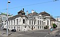
Auersperg Palace; Lerchenfelder Straße begins on the left

Lerchenfelder Straße at Kellermanngasse towards west
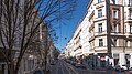
Lerchenfelder Strasse at Stolzenthalergasse in the direction of Gürtel

House of St. Peter (No. 6)

Schott Durchhaus (No. 13)

Lerchenfelder Strasse 35

Lerchenfelder Strasse 54–56
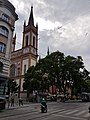
Alt-Lerchenfelder parish church and Ceija-Stojka-Platz
.JPG)


.jpg)


literature
- Bundesdenkmalamt (Ed.): Dehio Handbuch - Die Kunstdenkmäler Österreichs, Vienna II. To IX. and XX. District , Verlag Anton Schroll & Co, ISBN 3-7031-0680-8 (cited as Dehio in the individual references )
Web links
Map of Lerchenfelder Straße in OpenStreetMap
Individual evidence
- ↑ a b Dehio p. 303
- ^ Vienna History Wiki , Lerchenfelder Strasse (accessed on February 28, 2020) names house no. 40 as the border; the plan of the Polizey district Josefstadt by Carl Graf Vasquez (approx. 1830) shows the border of the street names at the Neue Gasse (today Lerchengasse ).
- ↑ Plan of the Polizey district Josefstadt
- ^ U2 line (Vienna), subsection: History. In: The Stadtverkehr Austria Wiki. Retrieved February 29, 2020 .
- ↑ a b Dehio p. 304