
Liechtenstein route
| Liechtenstein cycle route | |||||||||||||||||||||||||||||||||||||||||
|---|---|---|---|---|---|---|---|---|---|---|---|---|---|---|---|---|---|---|---|---|---|---|---|---|---|---|---|---|---|---|---|---|---|---|---|---|---|---|---|---|---|

|
|||||||||||||||||||||||||||||||||||||||||
| overall length | approx. 98 km | ||||||||||||||||||||||||||||||||||||||||
| location |
|
||||||||||||||||||||||||||||||||||||||||
| Starting point |
Wilfersdorf 48 ° 35 ′ 21 ″ N , 16 ° 38 ′ 41 ″ E |
||||||||||||||||||||||||||||||||||||||||
| Target point |
Wilfersdorf 48 ° 35 ′ 21 ″ N , 16 ° 38 ′ 41 ″ E |
||||||||||||||||||||||||||||||||||||||||
| Flooring | in Austria paved goods roads , in the Czech Republic natural forest roads |
||||||||||||||||||||||||||||||||||||||||
| Height difference | 937 m up / 937 m down | ||||||||||||||||||||||||||||||||||||||||
| difficulty | difficult | ||||||||||||||||||||||||||||||||||||||||
| Traffic volume | mostly own bike path | ||||||||||||||||||||||||||||||||||||||||
|
Route
|
|||||||||||||||||||||||||||||||||||||||||
The Liechtenstein route or Liechtenstein-Fürstenroute , Czech Liechtensteinská stezka , is a cross-border cycle route from Lower Austria to South Moravia . It is located in the border triangle between Austria, the Czech Republic and Slovakia, whereby Slovakia is not affected by the cycle path.
The name comes from the Liechtenstein people , who had a great cultural influence over centuries in this area where the cycle path runs.
Accordingly, the cycle route begins at Wilfersdorf Castle , which is still owned by the Liechtensteiners today, past Prinzendorf Castle via Neusiedl an der Zaya to Altlichtenwarth . The route continues via Bernhardsthal to Reintal , where you cross the border to the Czech Republic . If you drive from Reintal directly to Schrattenberg, you stay on Austrian territory. The route will be shortened to 68 km.
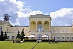
Here you come to spacious parks that are located in the Lednice-Valtice cultural landscape . Passing the eastern pond you get to Lednice, past numerous Liechtenstein buildings . The Lednice castle with the vast palace gardens forms the northernmost point of the route.
To the south it leads past the western pond to Valtice Castle , where it shortly afterwards reaches Austrian territory.
photos
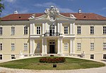
Starting point at Wilfersdorf Castle
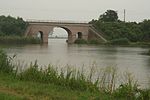
Bernhardsthaler pond
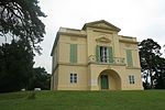
Pond castle

Lednice Castle
Grenzschlösschen

Valtice Castle
Poysdorf

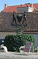
Information board at Schrattenberg


Web links
- Liechtenstein cycle route accessed on the Lower Austria portal in May 2016
- wissenswertes.at
- Bicycle tour Liechtenstein route ( Memento from August 29, 2010 in the Internet Archive )