Bernhardsthal
|
market community Bernhardsthal
|
||
|---|---|---|
| coat of arms | Austria map | |
|
|
||
| Basic data | ||
| Country: | Austria | |
| State : | Lower Austria | |
| Political District : | Mistelbach | |
| License plate : | MI | |
| Surface: | 52.01 km² | |
| Coordinates : | 48 ° 42 ' N , 16 ° 52' E | |
| Height : | 166 m above sea level A. | |
| Residents : | 1,582 (January 1, 2020) | |
| Population density : | 30 inhabitants per km² | |
| Postal code : | 2275 | |
| Area code : | 02557 | |
| Community code : | 3 16 04 | |
| NUTS region | AT125 | |
| UN / LOCODE | AT SXA | |
| Address of the municipal administration: |
Hauptstrasse 65 2275 Bernhardsthal |
|
| Website: | ||
| politics | ||
| Mayoress : | Doris Kellner ( ÖVP ) | |
|
Municipal Council : ( 2020 ) (19 members) |
||
| Location of Bernhardsthal in the Mistelbach district | ||
 Viaduct of the northern railway in the Bernhardsthaler pond by Carl Ritter von Ghega |
||
| Source: Municipal data from Statistics Austria | ||
Bernhardsthal is a market town with 1582 inhabitants (as of January 1, 2020) in the Mistelbach district in Lower Austria .
geography
Bernhardsthal is located in the far northeast of the Lower Austrian Weinviertel near the Thaya on the border with the Czech Republic . The area of the market town covers 51.93 square kilometers. 6.18 percent of the area is forested.
Nearby waters are the Bernhardsthaler pond and the Thaya .
Community structure
The municipality includes the following three localities (population in brackets as of January 1, 2020):
- Bernhardsthal (819)
- Katzelsdorf (344)
- Reintal (419)
The community consists of the cadastral communities Bernhardsthal, Katzelsdorf and Reintal.
Neighboring communities
| Břeclav , Czech Republic | Lanžhot , Czech Republic | |
| Schrattenberg |

|
|
| Altlichtenwarth | Hausbrunn | Rabensburg |
history
The archaeological finds in the local area indicate a settlement from the Neolithic and Bronze Ages . A settlement west of the place comes from the Lengyel culture , a dog burial close to the Unrest was dated to 4300 BC. Dated. At the same place 2000 years later there was a burial ground from the Early Bronze Age (around 2000 BC) that is assigned to the Aunjetitz culture. "The Three Mountains", as the local group of barrows is called, date from the Older Iron Age ( Hallstatt period , 800–400 BC).
An excavation by the Federal Monuments Office between 1974 and 1980 found a Germanic settlement on the Thaya from the 1st to 4th centuries. The pointed ditch of a Roman marcher ran right through it, a relic from the advance of Marcus Aurelius (around 178 AD). Slavic settlements date from the 6th to 9th centuries. Pohansko, located just northeast of the local border in Břeclav / Lundenburg, was a center of the Great Moravian Empire in the 9th century. The "Bernhardsthaler Lead Cross" with a depiction of Christ comes from the mission attempts of this time - four scattered crosses from the same mold trace the path of a Bavarian mission group via Gars am Kamp , Dolní Věstonice and Bernhardsthal to Mikulčice .
During the "German settlement" around 1050, the present day Bernhardsthal could have been founded. The settlement was, as only discovered when the "Great Pond" was dredged in 2009, partly in the middle of today's pond area . Bernhardsthal was first mentioned in a document in 1171 in the Klosterneuburg tradition code (... dominus Ortolfus be Waidehoven fundum Bernhardsthal).
At the same time, around 1200, construction began on the Romanesque nave of the current church, and a Gothic choir soon followed. The place must have been significant at the time, because Reinhard von Wehingen was granted market rights in 1370 for Bernhardsthal ( ... in his market in Pernharcztal, located in our land of Austria ... ). Rapid changes of ownership during this time reached their penultimate level when the Roggendorfer acquired Bernhardsthal from Hans dem Hering in 1423. In the wars with Podieprad in 1458 the Roggendorfer burned down the Bernhardsthal fortress, located on the Jägerhausberg, themselves. It was not rebuilt. Finally in 1470 they sold Bernhardsthal with the castle and three ponds to the Liechtensteiners (including the desolate village of Ebenfeld ).
The Reformation brought Lutheran preachers to Bernhardsthal from 1566 to around 1600. In the course of the strict Counter-Reformation , the first list of all Bernhardsthalers was created in 1631. Warranty and land register (1644) give us more information about the place, which was devastated by the Swedes under Lennart Torstensson in 1645 . This destruction was not the first, more followed up to the Kuruczuges around 1704 - in the reference books it is written about captured heirs, desolate houses etc. From 1700, birth, death and marriage registers have also been preserved.
Bernhardsthal, originally part of the Passau Deanery Hohenleithen, came to the Archdiocese of Vienna in 1783. In 1790 the church tower was built to replace a roof turret. In 1805 and 1809, the billeting of French troops encouraged pastors who wrote annual reports from 1800 to write longer articles. A radical change in the economic and social structure brought about the establishment of the " Kaiser-Ferdinands-Nordbahn " in 1839 . Soon a considerable part of the population worked for the railroad.
Leutgeb, bailiffs and village judges are known by name from earlier times, but the first mayoral election took place on July 18, 1850 - Josef Stättner, 43 years old, full-time worker from No. 21, becomes mayor.
The next drastic change took place in 1919. Bernhardsthal, like the neighboring towns of Reintal and Rabensburg, lost part of its local area and became a border town to Czechoslovakia . Many old family ties are now handicapped until they are finally severed in 1946. Owners of agricultural land in the CSFR receive special passes.
The years before and after the First World War saw rapid population growth with high birth rates and immigration. In the 1923 census, the town reached its highest population figure of 1,723, this level lasted until 1951. In 1925 the monastery “St. Martha ”with a kindergarten and housekeeping school.
Between 1930 and 1935, the Thaya-Gesellschaft announced a new economic change with the first drilling for oil near the Föhrenwald, which was unsuccessful. The oil and gas fields "Mühlberg" and "Bernhardsthal" were expanded under German administration, from 1945 under the Soviet occupying power and finally under OMV. After all, around 1956, almost 600 people were employed on the Mühlberg. The promotion also brought the early (1947/48) connection to the natural gas network and continues to this day.
In 1938, Bernhardsthal and Katzelsdorf allegedly supported the Anschluss without opposing votes . There was no fighting in the town itself during World War II , but four residents were killed and several buildings destroyed in an air raid on April 7, 1945. The withdrawing German troops blew up three bridges, including two railway bridges. On April 17th soldiers of the Red Army marched into Bernhardsthal. After the war Bernhardsthal became a place on a dead border and fell into the Soviet occupation zone .
After the state treaty and the end of the occupation in 1955, new life began in the village, in 1957/58 a new elementary school was built, a Red Cross post was set up in 1958, the funeral hall at the church was built in 1959, a new sports field on the grounds of the 1961/62 "Kesselteiches" was created and in 1963 the new town hall opened in place of the old school with a municipal office, registry office, post office, gendarmerie post and mother advisory service.
The decreasing population as well as the increased tasks of the municipalities and requirements of the state of Lower Austria led to the amalgamation of the municipalities Bernhardsthal, Katzelsdorf and Reintal to form the greater municipality Bernhardsthal in the course of the municipality reform on January 1st, 1971.
Further infrastructure improvements were made in 1972 with the establishment of tennis courts and in 1974/75 with the completion of the construction of the Bernhardsthal water supply system. The opening of the gymnasium and the local history museum (Prehistory, Prehistory and Folklore Department) was honored at the (somewhat belated) 800 year celebration on July 1-3, 1977. Governor Andreas Maurer awarded the new market coat of arms (the old market rights were lost at an unknown time).
The pond, which has shaped the townscape since around 1400 and originally covered 33 hectares , was finally drained by the Liechtenstein administration in 1972. The community acquired the land by 1992, had it dredged and finally covered the pond again from September 17, 1992. In 1999 a rest house was opened by the pond, in 2008 the introduced mud was removed again and a medieval settlement of at least eight hectares was discovered in the middle of the large pond.
coat of arms
Blazon : "Split between red and blue, in front a tinned golden wall growing out of the base of the shield with two black loopholes, above a floating golden cross, behind a silver zigzag bar."
Red and blue are the princely Liechtenstein colors, the silver zigzag bar is the coat of arms of the Wehingers , who in 1370 gave the place market rights. The crenellated wall is intended to remind of the former fortifications and the cross of the Bernhardsthal lead cross found in 1931 as a grave object.
Population development
After a sharp decline in the number of inhabitants in the last decades of the 20th century, it has stabilized, as the negative birth balance is almost offset by a positive migration balance .

politics
The municipal council has 19 members.
- With the municipal council elections in Lower Austria in 1990, the municipal council had the following distribution: 10 ÖVP and 9 SPÖ.
- With the municipal council elections in Lower Austria in 1995, the municipal council had the following distribution: 10 ÖVP and 9 SPÖ.
- With the municipal council elections in Lower Austria in 2000, the municipal council had the following distribution: 10 ÖVP and 9 SPÖ.
- With the municipal council elections in Lower Austria in 2005 , the municipal council had the following distribution: 10 ÖVP and 9 SPÖ.
- With the municipal council elections in Lower Austria 2010 , the municipal council had the following distribution: 11 ÖVP and 8 SPÖ.
- With the municipal council elections in Lower Austria in 2015 , the municipal council had the following distribution: 11 ÖVP and 8 SPÖ.
- With the municipal council elections in Lower Austria 2020 , the municipal council has the following distribution: 11 ÖVP and 8 SPÖ.
- mayor
- until 2005 Johann Saleschak (ÖVP)
- 2005–2018 Alfred Ertl (ÖVP)
- since 2018 Doris Kellner (ÖVP)
Culture and sights
- Railway viaduct of the Emperor Ferdinand's Northern Railway in the pond, built in 1839 under Carl Ritter von Ghega . This brick railway bridge is the oldest preserved railway structure in Austria.
- Heimatmuseum (since July 1, 1977), renamed "Otto Berger" Heimatmuseum in 1994.
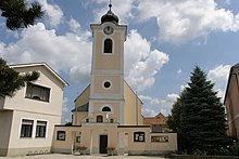
- Catholic parish church Bernhardsthal hl. Aegydius
- Catholic parish church Reintal for St. Trinity
- Catholic parish church Katzelsdorf hl. Bartholomew
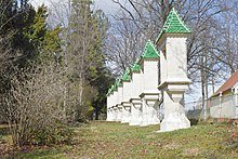
- Rosary Park Katzelsdorf
economy
In 2001 there were 46 non-agricultural workplaces, according to the 1999 survey a total of 131 agricultural and forestry holdings. According to the 2001 census, the number of people in work at the place of residence was 629. The employment rate in 2001 was 38.45 percent.
traffic
- Rail: Bernhardsthal station is the last stop on the Austrian Northern Railway . This is where the Czech railway lines Břeclav – Brno and Břeclav – Petrovice u Karviné begin .
Public facilities
- Town hall (since 1965 at No. 65, previously at No. 62, today Otto Berger Heimatmuseum)
- General practitioner (the first known Bader is mentioned in the parish register in 1717 )
- Bernhardsthal elementary school (a community school is mentioned for the first time in 1787, and has also been an elementary school for the children from Katzelsdorf and Reintal since 1974/75)
- Bernhardsthal volunteer fire brigade (since January 15, 1891)
- Kindergarten (in the monastery "St. Martha", founded in 1926 as a private kindergarten, since 1930 state kindergarten)
- Local office of the Red Cross (since 1958)
- dentist
- Fire brigade showroom ("Am Teich", since June 27, 2009)
- Reintal
- Municipal office (until about 1900 the Halterhaus was at No. 107, after that house No. 210 was adapted, in 1963 a new building was built at No. 210)
- Reintal Volunteer Fire Brigade (since 1884)
Sports
- Bernhardsthaler Eisstocksportverein 99 (BEV 99, since 1999) / Asphaltstockplatz (since 1999)
- Tennis club (TV) Bernhardsthal (since 1973) / tennis court (since 1973)
- SC Bernhardsthal (1934–2011) / football field (1962–2014)
- Eisstock Club (ESC) Reintal
- Reintal tennis club
societies
- Village renewal association (DoErn) Bernhardsthal (founded on September 19, 1970 as a beautification association)
- Comradeship Association (initially a branch of the Austro-Hungarian Military Veterans Association founded in Feldsberg in 1898 ). In 1912 a kuk military veterans association was founded in Bernhardsthal, 1938 dissolution, since March 17, 1957 "Austrian Comradeship Association - Bernhardsthal Local Association"
- Kinderfreunde Bernhardsthal (since April 12, 2005)
- Church choir (first mentioned in 1706)
- Musikverein Bernhardsthal and surroundings (consisting of the local chapels Bernhardsthal (founded 1890), Katzelsdorf (1862) and Reintal (1921), combined in 1977 to form the "Musikverein Bernhardsthal and surroundings")
- War Victims and Disabled Association (first founded in 1948, re-founded in 2010)
- Bernhardsthal Youth Association (since December 13, 2016)
- Seniorenbund Bernhardsthal (since?)
- Reintal
- Village renewal association Reintal (since?)
- Großgemeindechor 2: gether (founded in 1998 as choir "2: gether", since 2002 association "2: gether - Großgemeindechor Bernhardsthal")
- Seniorenbund Reintal (since?)
Personalities
- Franz Hlawati (1868–1940), politician, clergyman and high school professor
literature
- "Bernhardsthal, contribution to the history of a Lower Austrian border town" by Franz Hlawati, 1938 (PDF file)
- Bernhardsthaler Heimatbuch (PDF file)
- The development of the village of Bernhardsthal (PDF file)
Web links
- 31604 - Bernhardsthal. Community data, Statistics Austria .
- Bernhardsthal Online
- For the excavation in the large pond Bernhardsthal, Sept / Oct 2008
Individual evidence
- ↑ Statistics Austria: Population on January 1st, 2020 by locality (area status on January 1st, 2020) , ( CSV )
- ^ Army History Museum / Military History Institute (HGM / MHI), Military History Research Department (MilFoA), study collection, inventory 1945, box 5, fasc. 45/9, municipality reports Lower Austria, District Mistelbach
- ^ Statistics Austria, A look at the community of Bernhardsthal, population development. Retrieved October 23, 2019 .
- ^ Result of the local council election 1995 in Bernhardsthal. Office of the Lower Austrian State Government, March 30, 2000, accessed on March 22, 2020 .
- ^ Election result of the municipal council election 2000 in Bernhardsthal. Office of the Lower Austrian State Government, February 4, 2005, accessed on March 22, 2020 .
- ^ Election result of the local council election 2005 in Bernhardsthal. Office of the Lower Austrian State Government, March 4, 2005, accessed on March 22, 2020 .
- ^ Election result of the municipal council election 2010 in Bernhardsthal. Office of the Lower Austrian State Government, October 8, 2010, accessed on March 22, 2020 .
- ^ Election result of the 2015 municipal council election in Bernhardsthal. Office of the Lower Austrian State Government, December 1, 2015, accessed on March 22, 2020 .
- ↑ Results of the municipal council election 2020 in Bernhardsthal. Office of the Lower Austrian State Government, January 26, 2020, accessed on March 22, 2020 .
- ^ Otto Berger Heimatmuseum im RegiowikiAT accessed on November 6, 2015


