
Readers' path

The Lieserpfad is a hiking trail in the Vulkaneifel and leads over 74 km in a predominantly southerly direction from Boxberg via Daun , Manderscheid and Wittlich to the town of Lieser on the Moselle . The hiking trail runs largely parallel to the Lieser River .
history

Initially, the Lieserpfad consisted of the two sections in the middle. The 42 km from Daun to Manderscheid and Manderscheid to Wittlich were referred to as Oberer and Unter Lieserpfad. This was followed by the stage up to the mouth of the Lieser and finally the Lieser spring path in 2012.
In 2015 the overall concept was revised, the Lieserpfad received uniform signage and a new logo, a blue "L" on green. The newly signposted route was opened on May 14, 2015.
Route
Boxberg - down
The path begins at the source of the Lieser, which is about 560 meters above sea level , near the village of Boxberg and runs along meadows and through some villages and forests to Daun, 15 kilometers away. There are two volcanic sour wells along the way .
Daun - Manderscheid
From Daun, the 18-kilometer path leads first along the Liesertal, through oak groves, and finally over a rocky path above the river and the Manderscheid castles .
Manderscheid - Wittlich
At 23 kilometers, the longest and most demanding section in terms of difficulty leads from Manderscheid over narrow and sometimes rocky paths along the deeply cut valley to Wittlich and offers numerous vantage points.
Wittlich - Lieser
The last stage leads from the historic city center of Wittlich 18 kilometers through fields, forests and meadows to the Moselle and ends in the municipality of Lieser.
Diverse names
The Lieserpfad leads through popular tourist areas of the Eifel, so that other hiking trails have integrated the Lieserpfad as a partial route:
- The Eifelsteig also leads from the Üdersdorfer Mühle to shortly before Großlittgen via the Lieserpfad.
- The waterfall path , also called "main hiking path 3" of the Eifelverein (length 134 kilometers), begins in Bad Münstereifel , meets the first section of the song path between Rengen and Daun, and then follows the same route to the common destination, the village of Lieser an der Moselle.
- The Vulkanweg from Andernach to Gerolstein, as "Hauptwanderweg 13" from the Eifelverein (length 163 kilometers), runs a short distance between Daun and Üdersdorf together with the Lieserpfad, and crosses it again in Manderscheid.
marketing
The further development of the path into a premium hiking trail is the goal of the Kelberg, Daun, Wittlich and Bernkastel-Kues tourist information offices, which have designed the redesign in cooperation with the neighboring communities, as well as the Eifelverein and the Vulkaneifel Nature and Geopark . The exuberant praise of Manuel Andrack in his book “You must hike” is used to promote advertising : “The Lieserpfad is the most beautiful hiking trail in the Eifel. The Eifel is the most beautiful low mountain range in Germany. Germany is the best hiking country in the world. So the Lieserpfad is the most beautiful hiking trail in the world. "
Awards
- 2nd place in the "Routes (long-distance hiking trail)" category in the 2018 public vote of the hiking magazine "Germany's most beautiful hiking trails"
Picture gallery
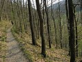
Upper Lieserpfad

Upper Lieserpfad
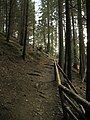
Upper Lieserpfad

Upper Lieserpfad
Upper Lieserpfad

Lower Lieserpfad
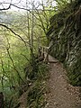
Lower Lieserpfad
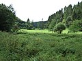
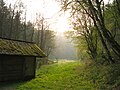
Forest clearing on the Lieserpfad

Water buffalo


literature
- Manuel Andrack: You have to hike. Without a stick and hat in the German low mountain range . Publishing house Kiepenheuer & Witsch, Cologne 2005, ISBN 3-462-03488-X
Web links
- www.lieserpfad.de
- Article in ZEIT about the Lieserpfad
- More information and pictures about the Lieserpfad
Individual evidence
- ↑ The Lieserpfad. In: wanderkompass.de. GesundLand Vulkaneifel GmbH, accessed on May 30, 2020 .
- ↑ Lieserquellpfad opened: A new piece of hiking happiness. Trierischer Volksfreund, September 10, 2012, accessed on May 30, 2020 .
- ↑ "Lieserpfad" opening - From the source to the mouth, opening hike with Manuel Andrack. Eifel Tourismus GmbH, May 4, 2015, accessed on May 30, 2020 .
- ↑ From the source to the mouth: New image for the Lieserpfad. Trierischer Volksfreund, March 30, 2015, accessed on May 30, 2020 .
- ↑ a b c d Lieserpfad. Tourist information offices Kelberg, Daun, Manderscheid, Wittlich, Bernkastel-Kues, accessed on May 30, 2020 .
- ↑ The stages of the Eifelsteig. In: Eifelsteig. Retrieved May 30, 2020 .
- ↑ Wasserfallweg (3): Bad Münstereifel - Lieser. Eifelverein, accessed on May 30, 2020 .
- ↑ Vulkanweg (13): Andernach - Gerolstein. Eifelverein, accessed on May 30, 2020 .
- ↑ Manuel Andrack promotes the Lieserpfad. Eifelzeitung, May 8, 2015, accessed on May 30, 2020 .
- ↑ Germany's most beautiful hiking trails 2018. In: Wandermagazin. OutdoorWelten GmbH, Bonn, August 15, 2018, accessed on May 30, 2020 .