|
|
designation
|
image
|
Date of registration
|
location
|
District
|
description
|
|
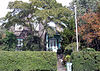
1
|
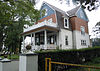
Elizabeth Alice Austen House
|

|
49700728 ♠July 28, 1970
|
2 Hylan Blvd.
40 ° 36 '54 " N , 74 ° 3' 49" W.40.615 -74.063611111111
|
Rosebank
|
|
|
2
|
Battery Weed
|

|
49720120 ♠20th January 1972
|
Fort Wadsworth Reservation
40 ° 36 ′ 19 ″ N , 74 ° 3 ′ 17 ″ W.40.605277777778 -74.054722222222
|
Fort Wadsworth
|
|
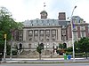
|
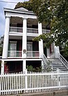
3
|
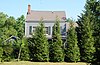
Billou-Stillwell-Perine House
|

|
49760101 ♠0January 1, 1976
|
1476 Richmond Rd.
40 ° 35 ′ 34 " N , 74 ° 6 ′ 3" W.40.592777777778 -74.100833333333
|
Dongan Hills
|
|
|
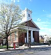
4th
|
Brighton Heights Reformed Church
|
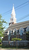
|
49820603 ♠03rd June 1982
|
320 St. Mark
40 ° 38 ′ 29 ″ N , 74 ° 4 ′ 43 ″ W.40.641388888889 -74.078611111111
|
Brighton Heights
|
|
|
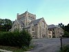
5
|
Calvary Presbyterian Church
|

|
50021121 ♠November 21, 2002
|
909 Castleton Ave.
40 ° 38 ′ 6 " N , 74 ° 6 ′ 47" W.40.635 -74.113055555556
|
West New Brighton
|
|
|
6th
|
Christ Church New Brighton (Episcopal)
|
|
50040527 ♠May 27, 2004
|
76 Franklin Ave.
40 ° 38 '36 " N , 74 ° 5' 36" W.40.643333333333 -74.093333333333
|
New Brighton
|
|
|
7th
|
St. Andrew's Church
|
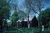
|
50001006 ♠0October 6, 2000
|
Arthur Kill and Old Mill Rd.
40 ° 34 '22 " N , 74 ° 8' 51" W.40.572777777778 -74.1475
|
Staten Island
|
|
|
8th
|
Conference House
|

|
49661015 ♠October 15, 1966
|
Hylan Blvd.
40 ° 30 ′ 10 " N , 74 ° 15 ′ 14" W.40.502777777778 -74.253888888889
|
Tottenville
|
|
|
9
|
Edgewater Village Hall and Tappen Park
|
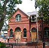
|
49800519 ♠May 19, 1980
|
bounded by Wright, Water, Bay and Canal St.
40 ° 37 ′ 36 ″ N , 74 ° 4 ′ 40 ″ W.40.626666666667 -74.077777777778
|
Stapleton
|
|
|
10
|
Dr. Samuel MacKenzie Elliott House
|
|
49800328 ♠March 28, 1980
|
69 Delafield Pl.
40 ° 38 ′ 38 ″ N , 74 ° 6 ′ 37 ″ W.40.643888888889 -74.110277777778
|
West New Brighton
|
|
|
11
|
Fire fighter
|

|
49890630 ♠June 30, 1989
|
Staten Island
|
Staten Island
|
|
|
12
|
Fort Tompkins Quadrangle
|

|
49740730 ♠July 30, 1974
|
Building 137, Fort Wadsworth
40 ° 36 ′ 0 ″ N , 74 ° 3 ′ 40 ″ W.40.6 -74.061111111111
|
Fort Wadsworth
|
|
|
13
|
Gardiner-Tyler House
|

|
49841123 ♠November 23, 1984
|
27 Tyler St.
40 ° 37 '24 " N , 74 ° 6' 48" W.40.623333333333 -74.113333333333
|
West New Brighton
|
|
|
14th
|
Garibaldi Memorial
|

|
49800417 ♠April 17, 1980
|
420 Tompkins Ave.
40 ° 36 ′ 54 " N , 74 ° 4 ′ 27" W.40.615 -74.074166666667
|
Rosebank
|
|
|
15th
|
Hamilton Park Community Houses
|

|
49830926 ♠September 26, 1983
|
105 Franklin Ave., 66 Harvard Ave. and 32 Park Pl.
40.641666666667 -74.090833333333
|
New Brighton
|
|
|
16
|
House at 5910 Amboy Road
|

|
49821216 ♠December 16, 1982
|
5910 Amboy Rd.
40 ° 31 ′ 32 ″ N , 74 ° 12 ′ 17 ″ W.40.525555555556 -74.204722222222
|
Prince's Bay
|
|
|
17th
|
Peter Houseman House
|

|
49821029 ♠October 29, 1982
|
308 St. John Ave.
40 ° 36 ′ 57 ″ N , 74 ° 8 ′ 12 ″ W.40.615833333333 -74.136666666667
|
Westerleigh
|
|
|
18th
|
Houses at 364 and 390 Van Duzer Street
|
|
49821114 ♠November 14, 1982
|
364 and 390 Van Duzer St.
40 ° 37 ′ 45 ″ N , 74 ° 4 ′ 47 ″ W.40.629166666667 -74.079722222222
|
Stapleton
|
|
|
19th
|
Jacques Marchais Center of Tibetan Art
|

|
50090529 ♠May 29, 2009
|
338 Lighthouse Ave.
40 ° 34 ′ 34.8 " N , 74 ° 8 ′ 18.5" W.40.576341666667 -74.138477777778
|
Staten Island
|
|
|
20th
|
Screech House
|
|
49821029 ♠October 29, 1982
|
4500 Arthur Kill Rd.
40 ° 31 ′ 57 ″ N , 74 ° 14 ′ 18 ″ W.40.5325 -74.238333333333
|
Charleston
|
built around 1885
|
|
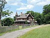
21st
|
Cruiser Pelton House
|
|
49730129 ♠January 29, 1973
|
1262 Richmond Ter.
40 ° 38 ′ 37 " N , 74 ° 6 ′ 43" W.40.643611111111 -74.111944444444
|
West New Brighton
|
|
|
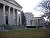
22nd
|
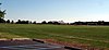
LaTourette House
|

|
49820305 ♠0March 5, 1982
|
Richmond Hill
40 ° 34 '34 " N , 74 ° 8' 50" W.40.576111111111 -74.147222222222
|
New Springville
|
1836 built brick building in the Federal style , which is now the club house of a standing in the municipal ownership golf course is
|
|
23
|
McFarlane-Bredt House
|
|
49830908 ♠0September 8, 1983
|
30 Hylan Blvd.
40 ° 36 '51 " N , 74 ° 3' 51" W.40.614166666667 -74.064166666667
|
Rosebank
|
|
|
24
|
Miller Army Air Field Historic District
|
|
49800411 ♠April 11, 1980
|
New Dorp Lane
40 ° 33 '51 " N , 74 ° 5' 44" W.40.564166666667 -74.095555555556
|
New Dorp Beach
|
|
|
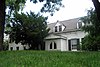
25th
|
Moore-McMillen House
|
|
49800423 ♠April 23, 1980
|
3531 Richmond Rd.
40 ° 34 ′ 21 ″ N , 74 ° 8 ′ 21 ″ W.40.5725 -74.139166666667
|
Egbertville
|
|
|
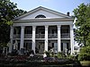
26th
|
Neville House
|

|
49770728 ♠July 28, 1977
|
806 Richmond Terrace
40 ° 38 ′ 40 ″ N , 74 ° 5 ′ 57 ″ W.40.644444444444 -74.099166666667
|
New Brighton
|
|
|
27
|
New Brighton Village Hall
|
|
49781215 ♠December 15, 1978
|
66 Lafayette Ave.
40 ° 38 '35 " N , 74 ° 5' 46" W.40.643055555556 -74.096111111111
|
New Brighton
|
|
|
28
|
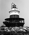
New Dorp Light
|

|
49730828 ♠August 28, 1973
|
Altamont Ave., Staten Island
40 ° 34 ′ 50.9 " N , 74 ° 7 ′ 12.7" W.40.580802777778 -74.120186111111
|
New Dorp
|
|
|
29
|
Office Building and US Light-House Depot Complex
|

|
49830915 ♠September 15, 1983
|
1 Bay St.
40 ° 38 ′ 28 ″ N , 74 ° 4 ′ 30 ″ W.40.641111111111 -74.075
|
St. George
|
|
|
30th
|
Old Orchard Shoal Light Station
|
|
50060920 ♠September 20, 2006
|
in Lower New York Bay, south of New Dorp Beach
40 ° 30 ′ 44 " N , 74 ° 5 ′ 56" W40.512222222222 -74.098888888889
|
Lower New York Bay
|
|
|
31
|
Our Lady of Mount Carmel Grotto
|

|
50001102 ♠0November 2, 2000
|
36 Amity St.
40 ° 36 ′ 44 ″ N , 74 ° 4 ′ 31 ″ W.40.612222222222 -74.075277777778
|
Rosebank
|
|
|
32
|
Poillon-Seguine-Britton House
|
|
49840202 ♠02nd February 1984
|
360 Great Kills Rd.
40 ° 32 ′ 44 ″ N , 74 ° 8 ′ 25 ″ W.40.545555555556 -74.140277777778
|
Great kills
|
|
|
33
|
Reformed Church on Staten Island
|
|
50050120 ♠January 20, 2005
|
54 Port Richmond Ave.
40 ° 38 '23 " N , 74 ° 7' 58" W.40.639722222222 -74.132777777778
|
Port Richmond
|
|
|
34
|
Sailors' Snug Harbor National Register District
|
|
49720316 ♠March 16, 1972
|
Richmond Ter.
40 ° 38 ′ 33 ″ N , 74 ° 6 ′ 10 ″ W.40.6425 -74.102777777778
|
Livingston
|
|
|
35
|
Sandy Ground Historic Archeological District
|
|
49820923 ♠23rd September 1982
|
Address classified
|
Staten Island
|
|
|
36
|
Scott-Edwards House
|

|
49830211 ♠February 11, 1983
|
752 Delafiel Ave.
40 ° 37 '43 " N , 74 ° 7' 26" W.40.628611111111 -74.123888888889
|
West New Brighton
|
|
|
37
|
Seaview Hospital
|

|
50050907 ♠0September 7, 2005
|
460 Brielle Ave.
40 ° 35 '30 " N , 74 ° 7' 58" W.40.591666666667 -74.132777777778
|
Willowbrook
|
|
|
38
|
Seguine House
|
|
49800506 ♠0May 6, 1980
|
440 Seguine Ave.
40 ° 31 ′ 0 ″ N , 74 ° 11 ′ 52 ″ W.40.516666666667 -74.197777777778
|
at Lemon Creek
|
|
|
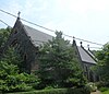
39
|
St. Alban's Episcopal Church
|

|
49821029 ♠October 29, 1982
|
76 St. Alban's Place
40 ° 32 '37 " N , 74 ° 9' 40" W.40.543611111111 -74.161111111111
|
Eltingville
|
|
|
40
|
St. Paul's Memorial Church and Rectory
|
|
49801121 ♠November 21, 1980
|
225 St. Pauls Ave.
40 ° 37 ′ 55 " N , 74 ° 4 ′ 46" W.40.631944444444 -74.079444444444
|
Stapleton
|
|
|
41
|
Standard Oil Company No. 16 (harbor tug)
|
|
50011129 ♠November 29, 2001
|
3001 Richmond Terrace
40 ° 38 ′ 18 ″ N , 74 ° 9 ′ 35 ″ W.40.638333333333 -74.159722222222
|
Mariners Harbor
|
|
|
42
|
Staten Island Borough Hall and Richmond County Courthouse
|
|
49831006 ♠0October 6, 1983
|
Richmond Terr.
40 ° 38 ′ 33 ″ N , 74 ° 4 ′ 35 ″ W.40.6425 -74.076388888889
|
St. George
|
|
|
43
|
Staten Island Light
|
|
50051130 ♠November 30, 2005
|
South side of Edinboro Rd., Between 402 and 426 Rd.
40 ° 34 ′ 33.6 ″ N , 74 ° 8 ′ 28.5 ″ W.40.576011111111 -74.141258333333
|
Staten Island
|
|
|
44
|
Louis A. and Laura Forehead House
|

|
50101112 ♠November 12, 2010
|
79 Howard Ave.
40 ° 37 '43 " N , 74 ° 5' 18" W.40.628611111111 -74.088333333333
|
Staten Island
|
New entry; Ref number 10000899
|
|
45
|
Temple Emanu-El
|

|
50070802 ♠0August 2, 2007
|
984 Post Ave.
40 ° 37 ′ 56 ″ N , 74 ° 8 ′ 3 ″ W.40.632222222222 -74.134166666667
|
Port Richmond
|
|
|
46
|
Voorlezer's House
|

|
49661015 ♠October 15, 1966
|
Arthur Kill Rd. Across from Center St.
40 ° 34 ′ 18 ″ N , 74 ° 8 ′ 52 ″ W.40.571666666667 -74.147777777778
|
Richmondtown
|
|
|
47
|
Caleb T. Ward Mansion
|

|
49820726 ♠July 26, 1982
|
141 Nixon Ave.
40 ° 38 ′ 3 " N , 74 ° 4 ′ 53" W.40.634166666667 -74.081388888889
|
Ward Hill
|
|
|
48
|
Ward's Point Conservation Area
|
|
49820929 ♠29th September 1982
|
Address classified
|
Tottenville
|
|
|
49
|
Wards Point Archeological Site
|

|
49930419 ♠April 19, 1993
|
Address classified
|
Tottenville
|
|
|
50
|
West Bank Light Station
|

|
50070109 ♠0January 9, 2007
|
Lighthouse in New York Bay, east of New Dorp Beach
40 ° 32 ′ 17 ″ N , 74 ° 2 ′ 35 ″ W40.538055555556 -74.043055555556
|
New Dorp Beach
|
|
|
51
|
Woodrow Methodist Church
|

|
49821029 ♠October 29, 1982
|
1109 Woodrow Rd.
40 ° 32 ′ 35 ″ N , 74 ° 12 ′ 6 ″ W.40.543055555556 -74.201666666667
|
Woodrow
|
|


.jpg)


_Light.JPG)
