List of cultural monuments in Nauberg
The list of cultural monuments in Nauberg contains the cultural monuments in the Grimma district of Nauberg shown in the official list of monuments of the State Office for the Preservation of Monuments in Saxony .
Legend
- Image: shows a picture of the cultural monument and, if applicable, a link to further photos of the cultural monument in the Wikimedia Commons media archive
- Designation: Name, designation or the type of cultural monument
-
Location: If available, street name and house number of the cultural monument; The list is basically sorted according to this address. The map link leads to various map displays and gives the coordinates of the cultural monument.
- Map view to set coordinates. In this map view, cultural monuments are shown without coordinates with a red marker and can be placed on the map. Cultural monuments without a picture are marked with a blue marker, cultural monuments with a picture are marked with a green marker.
- Dating: indicates the year of completion or the date of the first mention or the period of construction
- Description: structural and historical details of the cultural monument, preferably the monument properties
-
ID: is awarded by the State Office for the Preservation of Monuments in Saxony. It clearly identifies the cultural monument. The link leads to a PDF document from the State Office for the Preservation of Monuments in Saxony, which summarizes the information on the monument, contains a map sketch and often a detailed description. For former cultural monuments sometimes no ID is given, if one is given, this is the former ID. The corresponding link leads to an empty document at the state office. The following icon can also be found in the ID column
 ; this leads to information on this cultural monument at Wikidata .
Nauberg
| image | designation | location | Dating | description | ID |
|---|---|---|---|---|---|
| Counting stone | Bischof-Benno-Ring (map) |
13./15. Century (counting stone) | medieval stone for taking tithes on payday, of cultural and historical importance
Rectangular stone (used for payments from farmers to the Buch monastery, probably from the Nauberger chapel) |
08974566
|
|
| Cottage | Bischof-Benno-Ring 11 (map) |
re. 1823, later reshaped | Upper floor originally half-timbered, boarded gable, segmental arch portal, evidence of smallholder building and way of life in the early 19th century, of social and historical importance
Marked 1823 (keystone), two-storey, solid ground floor, upper floor originally half-timbered, later massively renewed, door and window frames in porphyry tufa, door frames with keystone in porphyry tuff, window sills on the upper floor in artificial stone, saddle roof, boarded gable |
08974565
|
|
| Barn of a three-sided farm | Bischof-Benno-Ring 16 (map) |
1st half of the 19th century | Evidence of rural economy of the 19th century, half-timbered barn, of architectural importance
|
08974567
|
|
| Side building of a four-sided courtyard | Bischof-Benno-Ring 17 (map) |
1st half of the 19th century | Testimony of rural economy in half-timbered construction, of architectural significance
Two-storey, solid ground floor, door walls probably in sandstone, upper floor half-timbered, boarded gable, half-hip roof |
08974564
|
|
 More pictures |
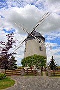
Nauberger Holländermühle (Tower Dutchman, with annex and technical equipment) | Zschoppacher Strasse 16 (map) |
1911 | The location of a windmill was documented cartographically as early as 1800, which is of importance in terms of local history and technology
Plastered solid construction, hood, inside: pinwheel, drive shaft, stone algae and timbers preserved and renovated in 2001 together with the sail gate wings |
08974571
|
| Barn, side building, courtyard paving and gate entrance of a four-sided courtyard | To Schanze 10 (map) |
Mid 19th century | Testimony to the rural architecture and way of life in the 19th century in half-timbered construction, stately courtyard, of importance in terms of building history and local history
|
08974563 |
