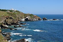
Lizard Point (Cornwall)
Lizard Point in Cornwall is the southernmost point of the Lizard Peninsula and also the southernmost point of England on the main island of Great Britain . Its northern counterpart is Dunnet Head in Scotland .
Lizard Point marks the northern entrance to the English Channel and is the only land point on the British main island which - if only a tiny bit - is located more south than the 50th parallel (corresponds to the German Mainz or the northern French Amiens ); even Land's End , which is often mistakenly considered the southernmost point of England, is north of the 50th parallel.
geology
The top is the best preserved example of an exposed oceanic crust in the UK. The rock at the top is still composed of serpentinite and metamorphic rock . Geological tours, in which the special geological situation is explained, are offered on site. In front of the top are some rocks called Velan Drang , Taylor's Rock , Snag Rock and Man O'War .
Surroundings
There are a few houses right on the top, the actual place The Lizard is about a kilometer north. Below the houses at the top is the old station of the Royal National Lifeboat Institution , but it is no longer in operation. Furthermore, the two lighthouses Lizard Lighthouse are a little east of the tip , only one of which is still in operation. Next to it is the Victorian-era hotel managed by the National Trust to keep it from deteriorating. It is now used as a youth hostel (YHA Lizard Youth Hostel). Like the hotel, Lizard Point is owned by the National Trust and has been under their protection since 1987.
In summer, up to 2500 visitors come to Lizard Point every day. To protect the landscape and separate through traffic from visitor traffic, the National Trust has created paths and parking lots. To beautify the landscape, power and telephone cables laid above ground were laid in the ground and 51 telegraph poles were removed.
North of Lizard Point is the medieval church of St. Wynwallow, the southernmost church building on the British mainland.
flora
In addition to the landscape, the originally preserved flora at the top is also worth preserving. Over 600 species of wildflowers are described here, including wild asparagus , bream herbs and Cornwall heather . Fifteen of the rarest plants native to the UK are found here.
Sea area
The first point in Great Britain to be seen by the ships of the Spanish Armada was Lizard Point on July 29, 1588. Shortly thereafter, the famous naval battle between the English and the Spanish broke out.
The sea area in front of Lizard Point, like that in front of Land's End, is an extensive ship graveyard. Ships from the English Channel aiming at the Irish Sea circle both peaks at a short distance. The last time the French fishing trawler Bugaled Breizh sank off Lizard Point on January 15, 2004 , drowned five sailors; The cause of the sinking could have been a collision with a submarine. The last large sailing ship to sink on the Lizard was the German five-master Adolf Vinnen on February 9, 1923.
Individual evidence
- ↑ Kirby, GA (1979): The Lizard Complex as an ophiolite. Nature, London, 282, pp. 58-61
- ↑ Malpas, J. & Langdon, GS (1987): The Kennack Gneiss of the Lizard Complex, Cornwall, England: partial melts produced during ophiolite emplacement. Canadian Journal of Earth Sciences 24, pp. 1966-1974
- ↑ Archived copy ( memento of the original from August 19, 2009 in the Internet Archive ) Info: The archive link was inserted automatically and has not yet been checked. Please check the original and archive link according to the instructions and then remove this notice.
- ↑ http://news.bbc.co.uk/2/hi/europe/4378899.stm
Web links
Coordinates: 49 ° 57 ′ 32 " N , 5 ° 12 ′ 23" W.


