Lohusuu
| Lohusuu | |||
|
|||
| State : |
|
||
| Circle : |
|
||
| Coordinates : | 58 ° 57 ' N , 27 ° 3' E | ||
| Area : | 102 km² | ||
| Residents : | 785 (2010) | ||
| Population density : | 8 inhabitants per km² | ||
| Time zone : | EET (UTC + 2) | ||
| Community type: | local community | ||
| Mayor : | Ant's hype
( SDE ) |
||
| Postal address : | Avinurme tea 49 42001 Lohusuu |
||
| Website : | |||

|
|||
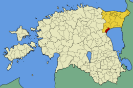
Lohusuu ( Lohusuu vald ) was a rural community in Ida-Viru County in northeast Estonia .
description
The rural community was in the south of the district. It borders on Estonia's largest lake, Lake Peipsi ( Peipsi järv ) , for 17 kilometers . Lohusuu vald had an area of 102 km². 785 inhabitants lived on it (as of January 1, 2010).
structure
In addition to the main town of Lohusuu , the rural community includes the villages of Jõemetsa , Kalmaküla , Kärasi , Ninasi , Piilsi , Raadna , Separa , Tammispää and Vilusi .
Municipal coat of arms
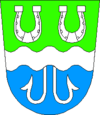
The upper part of the coat of arms indicates the forests and fields of the municipality. The lower blue field stands for Lake Peipus . The colors green and blue also symbolize the historical affiliation to the Tartu district . Silver stands for the Ida-Viru district .
The two horseshoes represent the Estonian-speaking and Russian-speaking population of the rural community and the historically important postal course that led through Lohusuu. The wavy line and fish hook indicate the rivers and fishing.
Personalities
- Otto Wilhelm Masing (1763–1832), Estonian pastor and linguist born in Lohusuu
Web links
- Official website (Estonian, Russian and English)
- Full description (Estonian)


