Lomná (Olsa)
| Lomná | ||
|
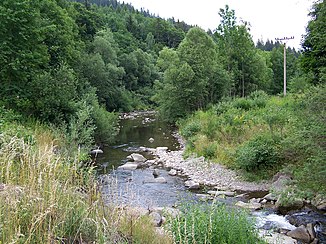
The Lomná in Dolní Lomná |
||
| Data | ||
| location | Moravskoslezský kraj , Czech Republic | |
| River system | Or | |
| Drain over | Olsa → Or → Stettiner Haff | |
| source | southwest of Hruška in the Jablunkauer Bergland 49 ° 29 ′ 54 ″ N , 18 ° 36 ′ 22 ″ E |
|
| Source height | 920 m nm | |
| muzzle | in Jablunkov in the Olsa coordinates: 49 ° 34 ′ 43 " N , 18 ° 45 ′ 52" E 49 ° 34 ′ 43 " N , 18 ° 45 ′ 52" E |
|
| Mouth height | 380 m npm | |
| Height difference | 540 m | |
| Bottom slope | 31 ‰ | |
| length | 17.5 km | |
| Catchment area | 70.76 km² | |
| Drain |
MQ |
1.46 m³ / s |
| Small towns | Jablunkov | |
| Residents in the catchment area | 10998 | |
The Lomná (German Lomna ) is a left tributary of the Olsa in the Czech Republic .
course
The Lomná rises southwest of Hruška near the Slovakian border in the Jablunkauer Bergland . Its source is located at the northern foot of the Čubaňov saddle (1101 m) between Burkov vrch (1031 m) and Malý Polom (1060 m). It flows through a deep, forested valley in which the villages of Hruška, Kyčmol, Horní Lomná , Stoligy and Tatínky are located, initially to the northeast. Below Tatínky the Lomná turns to the east and flows through Radošonka and Dolní Lomná . The river then takes a north-easterly direction and is bridged by the Žilina – Bohumín railway line, which then follows the Lomná to Jablunkov. East of Novina, the Lomná flows after 13 kilometers out of its wooded mountain valley into the Jablunkau furrow ( Jablunkovská brázda ). Along its lower reaches are the places Pod Břehy, Městská Lomná, Bocanovice , Ošetnice, Červená and Jablunkov . On the northern outskirts of Jablunkov, the Lomná finally flows into the Olsa after 17.5 kilometers .
nature
At the Kyčmol settlement, on the left side of the river, there is a peat meadow protected as a Kyčmol natural monument .
North-east of Horní Lomná, the Mionší National Nature Reserve extends along the Velká Polana (893 m) with its primeval forest of fir and beech trees.
Tributaries
- Vontrubový potok (r), below Hruška
- Kyčmol (l), below Kyčmol
- Malý Burkovský potok (r), above Horní Lomná
- Velký Burkovský potok (r), Horní Lomná
- Upaloný potok (l), Horní Lomná
- Přelač or Přelačský potok (r), Horní Lomná
- Suchý potok (l), Horní Lomná
- Úplaz or Úplazský potok (r), Horní Lomná
- Lačnovský potok (l), Horní Lomná
- Stoligy (l), Stoligy
- Tatínky or Tatínský potok (l), Tatínky
- Rusňok (l), Tatínky
- Kamenitský potok (l), below Tatínky
- Mionší potok (r), above Radošonka
- Glovčin (l), below Glovčín
- Smolkovský potok (r), above Radošonka
- Polanský potok (l), opposite Radošonka
- Jestřábský potok (r), Radošonka
- Křínovský potok (r), Dolní Lomná
- Mostařanka (r), Dolní Lomná
- Žabník (r), Dolní Lomná
- Ošetnice (r), Ošetnice
Web links
