Jablunkov
| Jablunkov | ||||
|---|---|---|---|---|
|
||||
| Basic data | ||||
| State : |
|
|||
| Historical part of the country : | Silesia | |||
| Region : | Moravskoslezský kraj | |||
| District : | Frýdek-Místek | |||
| Area : | 1038 ha | |||
| Geographic location : | 49 ° 34 ' N , 18 ° 46' E | |||
| Height: | 386 m nm | |||
| Residents : | 5,547 (Jan 1, 2019) | |||
| Postal code : | 739 91 | |||
| traffic | ||||
| Street: | Třinec - Čadca | |||
| Railway connection: | Žilina – Bohumín | |||
| structure | ||||
| Status: | city | |||
| Districts: | 1 | |||
| administration | ||||
| Mayor : | Jiří Hamrozi (as of 2014) | |||
| Address: | Dukelská 144 739 91 Jablunkov |
|||
| Municipality number: | 598259 | |||
| Website : | www.jablunkov.cz | |||
Jablunkov ( German Jablunkau , Polish Jabłonków ) is a city in the Czech Republic . It is located 13 kilometers southeast of Třinec in the Beskids, not far from the border with Poland and Slovakia, and belongs to the Frýdek-Místek district .
geography
Jablunkov is located at the confluence of the Lomna in the Olsa in the center of the Jablunkov furrow ( Jablunkovská brázda ) in the Jablunkauer Uplands . The mountain range of the Silesian Beskids extends to the east and the Moravian-Silesian Beskids to the southwest .
Neighboring towns are Nawsi in the north, Písečná in the east, Písek in the south-east, Mosty u Jablunkova in the south, Bozonowitz in the south-west and Millikau in the west.
traffic
The European route 75 / state road Silnice I / 11 leads through the town from Český Těšín to Čadca in Slovakia . In addition, there is another road border crossing into the Polish city of Istebna near Bukovec . The international long-distance railway connection Žilina – Bohumín runs west past Jablunkov, the nearest train station is in Návsí (Nawsie).
history
Jablunkov was first mentioned in a document in 1423 in a document by Duke Wenceslaus I. The place name translates into German as apple tree , which is also indicated by the town's coat of arms with a stylized apple tree. Jablunkov was part of the Silesian Duchy of Teschen and was originally located near the Hrádek Castle . After the castle and the village were destroyed by the Hungarians in 1447, the place was rebuilt in its current location. Since 1496 Jablunkov had the status of a market. Duke Wenceslaus III. Adam granted the place city rights in 1560. In 1599 a plague epidemic broke out.
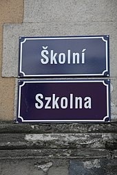
On November 23, 1938, the protocol for the demarcation of the state border between Poland and Czechoslovakia according to the Munich Agreement was signed in Jablunkau , whereby the city came to Poland as Jabłonków . After the occupation of Poland, the city was incorporated into the district of Teschen and belonged to the German Empire until 1945. After the end of the Second World War, the city came back to Czechoslovakia. A Polish-speaking minority still lives in Jablunkov.
Between 1868 and 1871 the Kaschau-Oderberger Railway was built , the course of which ran northwest past Jablunkau. 1960 Návsí and Bocanovice were incorporated. In 1975 Horní Lomná, Dolní Lomná, Bukovec and Písek were incorporated, and finally in 1980 by Hrádek. As a result, Jablunkov had 15,973 inhabitants, of which 5299 were Poles and 209 Slovaks. After the Velvet Revolution , on July 1, 1990, all of the incorporated villages except Návsí broke away from Jablunkov and became independent. On January 1, 1994, Návsí also split, and in 1996 the name dispute over the station in Návsí was settled by giving it the name Jablunkov-Navsí . In July 2009, the reference to Jablunkov disappeared and the station has been called Návsí (Nawsie) since then . At the beginning of 2001, the new municipality Písečná was formed from several hamlets on the eastern outskirts .
In 1935 a sanatorium was established in Jablunkov. Today the sanatorium serves as a sanatorium for tuberculosis and other respiratory diseases.
Local division
No districts are shown for the city of Jablunkov. A large number of small hamlets belong to Jablunkov.
Twin cities
- Gogolin , Poland
- Siemianowice Śląskie , Poland
Attractions
- Marienplatz with city fountain and column of the Immaculate
- Town hall, built in 1904 in secession style
- Corpus Christi Church
- Building of the lung clinic
- St. Elisabeth Monastery, built in 1928
- Jewish Cemetery
sons and daughters of the town
- Maximilian Hantken (1821-1893), paleontologist, director of the k. Hungarian geological institute in Budapest
- Cornelius Netter (1883–1954), mechanical engineer and university professor
Web links
Individual evidence
- ↑ Český statistický úřad - The population of the Czech municipalities as of January 1, 2019 (PDF; 7.4 MiB)
- ↑ Ladislav Hošák, Rudolf Šrámek: Místní jména na Moravě a ve Slezsku , Vol. 1: A - L . Prague 1970.


