
Istebna
| Istebna | |||
|---|---|---|---|

|
|
||
| Basic data | |||
| State : | Poland | ||
| Voivodeship : | Silesia | ||
| Powiat : | Cieszyn | ||
| Area : | 84.25 km² | ||
| Geographic location : | 49 ° 34 ' N , 18 ° 54' E | ||
| Height : | approx. 500 m npm | ||
| Residents : | 5076 (March 31, 2011) | ||
| Postal code : | 43-470 | ||
| Telephone code : | (+48) 33 | ||
| License plate : | SCI | ||
| Economy and Transport | |||
| Next international airport : | Katowice | ||
| Gmina | |||
| Gminatype: | Rural community | ||
| Gmina structure: | 3 localities | ||
| 3 school offices | |||
| Residents: | 12,129 (Jun. 30, 2019) |
||
| Community number ( GUS ): | 2403092 | ||
| administration | |||
| Website : | istebna.eu | ||

Istebna is a village and seat of the rural community ( gmina wiejska Istebna ) in the district of Teschen ( Powiat Cieszyński ) in the Silesian Voivodeship in Poland . Three villages belong to the municipality: Istebna, Jaworzynka and Koniaków. From 1975 to 1998 Istebna was part of the Bielsko-Biała Voivodeship .
geography
The rural municipality of Istebna is located in the south of the Silesian Beskids about 15 km south of Wisła . The village of Istebna lies at the foot of the Złoty Groń mountain (707 m) in the headwaters of the Olsa .
history
The first written mention of Istebna is from 1577. The village belonged to the Duchy of Teschen , which was under the Silesian line of the Piasts until 1625 and came under the rule of the Habsburgs from 1653.
The Silesian Beskids were settled in the 15th century, from two directions:
- Farmers from the northern lowlands of Silesia
- Nomads ("Wallachians") from the Carpathian Mountains from 1494
The ethnic groups mixed, with parts of the clothing and beliefs being taken from the Carpathian Mountains.
local community
The rural community ( Gmina ) Istebna includes the three Goralen villages: Istebna, Jaworzynka (German Jaworzinka ) and Koniaków (German Koniakau ). Due to their remote location in the Silesian Beskids, they are also referred to as the “Three Beskids Villages” ( Beskidzka Trójwieś ). The community has about 11,500 inhabitants. The area is about 84 km².
Numerous districts belong to the three communities: Kubalonka, Olecki, Wilcze, Andziołówka, Połom, Stecówka, Mlaskawka, Jasnowice, Trzycatek and Zapasieki.
The municipality of Istebna borders the municipalities of Milówka , Zwardoń and Wisła , and the municipality borders the state border with the Czech Republic with the municipalities of Bukovec , Hrčava and Jablunkov and with Slovakia with the municipalities of Čierne and Skalité .
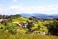
The Three Beskid Villages

View over Istebna and Złoty Groń Mountain

View over Jaworzynka
View over Koniaków
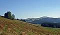
View from Jaworzynka to Mount Ochodzita


Attractions
- Jan Kawulok Village Museum in Istebna
- Konarzewski family museum and picture gallery
- Museum of the painter and graphic artist Jan Walach in Istebna
- Regional museum "Na Grapie" in Jaworzynka (folk art of the Gorals)
- Maria Gwarek Lace Museum in Koniaków
- Regional Museum in Koniaków
- Church of the Good Shepherd in Istebna ( Kościół Dobrego Pasterza ) (1794)
- Wooden churches in Stecówka and Kubalonka
Churches

- Church of the Good Shepherd in Istebna ( Kościół Dobrego Pasterza ) (1794)
- Church of St. Joseph in Mlaskawka ( Kościół Św.Józefa na Mlaskawce )
- Church of Our Lady of Fatima in Stecówka ( Kościół Matki Bożej Fatimskiej w Stecówce )
- Church of Exaltation of the Cross in Kubalonka ( Kościół Podwyższenia Krzyża )
- Evangelical Church in Istebna (1927–1930)
- Bartholomeus Church in Koniaków ( Kościół Św.Bartłomieja w Koniakówi ) (1901)
- Church of St. Peter and Paul in Jaworzynka ( Kościół Św.Piotra i Pawła )
- Church of Our Lady in Jaworzynka-Trzycatek ( Kościół pw Matki Bożej Frydeckiej Trzycatek )
Sons and daughters
- Jan Legierski (* 1952), Polish Nordic combined skier
- Stanisław Kawulok (* 1953), Polish Nordic combined skier
- Waldemar Pytel (* 1958), Lutheran theologian, from 2015 bishop of the diocese of Wroclaw
- Wiesław Krótki OMI (* 1964), Catholic Bishop of Churchill-Baie d'Hudson
Web links
Individual evidence
- ^ CIS 2011: Ludność w miejscowościach statystycznych według ekonomicznych grup wieku (Polish), March 31, 2011, accessed on July 4, 2017
- ↑ population. Size and Structure by Territorial Division. As of June 30, 2019. Główny Urząd Statystyczny (GUS) (PDF files; 0.99 MiB), accessed December 24, 2019 .
