
Koniaków
| Koniaków | |||
|---|---|---|---|

|
|
||
| Basic data | |||
| State : | Poland | ||
| Voivodeship : | Silesia | ||
| Powiat : | Cieszyn | ||
| Gmina : | Istebna | ||
| Area : | 14.69 km² | ||
| Geographic location : | 49 ° 33 ' N , 18 ° 56' E | ||
| Height : | 630 m npm | ||
| Residents : | 3643 (2012) | ||
| Postal code : | 43-476 | ||
| Telephone code : | (+48) 33 | ||
| License plate : | SCI | ||

Koniaków ( German Koniakau ) is a village with a Schulzenamt of the municipality Istebna in the Powiat Cieszyński of the Silesian Voivodeship in Poland .
geography
Koniaków is located in the south of the Silesian Beskids , east of Istebna on the slope of the mountain Ochodzita (895 m), about 30 km southwest of Bielsko-Biała and 80 km south of Katowice in the powiat (district) Cieszyn.
The village has an area of 1469 hectares (18% of the parish).
Neighboring towns are Istebna in the west and north, Kamesznica and Laliki in the east, Zwardoń in the south and Jaworzynka in the southwest.
history
The village is located in the Olsa region (also Teschner Schlesien , Polish Śląsk Cieszyński ).
The settlement began by residents of Istebna in the first half of the 17th century, but was forbidden by the Teschen dukes when the forest was an important border with Poland during the Thirty Years War (the village belonged to the Habsburg monarchy ). Chalupy na Koniakowie ( stalls in Koniaków ) were mentioned in the years 1695-1712. The year 1712 is held as the founding year (e.g. the public holiday in 2012), but the independence of Istebna was only achieved in 1816. The name may have been inherited from Koniakau near Teschen.
After the abolition of patrimonial Koniaków formed from 1850 a municipality in Austrian Silesia , Teschen district and Jablunkau district . In the years 1880–1910 the population rose from 857 in 1880 to 1120 in 1910, all of the inhabitants were Polish-speaking. In 1910, 88.7% were Roman Catholics and 11.3% were Protestants.
In 1920, after the collapse of the Austro-Hungarian monarchy and the end of the Polish-Czechoslovak border war , Koniaków became part of Poland. This was only interrupted by the occupation of Poland by the Wehrmacht in World War II .
From 1975 to 1998 Koniaków was part of the Bielsko-Biała Voivodeship .

Place view
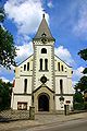
church

museum


Sons of the place
- Erwin Fiedor (1943–2012), Nordic skier
- Andrzej Fiedor (* 1946), biathlete
Web links
Footnotes
- ↑ a b c Robert Mrózek: Nazwy miejscowe dawnego Śląska Cieszyńskiego . Uniwersytet Śląski w Katowicach , 1984, ISSN 0208-6336 , p. 93-94 (Polish).
- ↑ Marcin Żerański: Śląsk Cieszyński od Bielsko-Białej do Ostrawy. Przewodnik turystyczny . Pracownia na Pastwiskach, Cieszyn 2012, ISBN 978-83-933109-3-7 , p. 264 (Polish).
- ^ Gmina Istebna: Powierzchnia gminy Istebna ( pl ) 2004.
- ↑ Historia Koniakowa wg Franciszka Popiołka: Koniaków przed stu laty
- ↑ Kazimierz Piątkowski: Stosunki narodowościowe w Księstwie Cieszyńskiem . Macierz Szkolna Księstwa Cieszyńskiego, Cieszyn 1918, p. 266, 285 (Polish, opole.pl ).
- ↑ Ludwig Patryn (ed): The results of the census of December 31, 1910 in Silesia , Opava 1912.
- ↑ Dz.U. 1975 no 17 poz. 92 (Polish) (PDF file; 783 kB)