
Wisła (city)
| Wisła | |||
|---|---|---|---|

|
|
||
| Basic data | |||
| State : | Poland | ||
| Voivodeship : | Silesia | ||
| Powiat : | Cieszyn | ||
| Area : | 110.26 km² | ||
| Geographic location : | 49 ° 39 ′ N , 18 ° 52 ′ E | ||
| Height : | 430 m npm | ||
| Residents : | 11,132 (Jun. 30, 2019) |
||
| Postal code : | 43-460 | ||
| Telephone code : | (+48) 33 | ||
| License plate : | SCI | ||
| Economy and Transport | |||
| Rail route : | Goleszów – Wisła | ||
| Next international airport : | Katowice | ||
| Gmina | |||
| Gminatype: | Borough | ||
| Residents: | 11,132 (Jun. 30, 2019) |
||
| Community number ( GUS ): | 2403031 | ||
| Administration (as of 2018) | |||
| Mayor : | Tomasz Bujok | ||
| Address: | Plac Hoffa 3 43-460 Wisła |
||
| Website : | www.wisla.pl | ||

Wisła ( [ Viswa ] ) (German Vistula , 1939-1945 Vistula OS , 1945 High Vistula ) is a town in Cieszyn County in the province of Silesia in Poland .
It is located in the Silesian Beskids on the Vistula River of the same name , which rises about ten kilometers southeast of the city.
The city is a center of winter sports as well as the Lutherans in Poland.
location

Wisła is located in the middle of the Silesian Beskids at the foot of the Barania Góra (1220 m above sea level) in the east and the Stożek Wielki (978 m above sea level) in the southwest. The neighboring municipalities are Brenna and Ustroń in the north, Szczyrk in the northeast, Lipowa , Radziechowy-Wieprz and Milówka in the east, Istebna in the south and the Czech Republic in the west.
The center of the village is at an altitude of 430 m and the surrounding valleys at heights of 300–600 m. The municipality extends up to 1220 m (in the summit of Barania Góra).
The source rivers of the Vistula , the Czarna and the Biała Wisełka , which merge with the Malinka to form the Vistula in the Jezioro Czerniańskie reservoir above the town center, arise at the Barania Góra .
Wisła has an area of 110.26 km², which includes 19% arable land and 74% forest. The municipality of Wisła thus makes up approx. 5% of the total area of Cieszyn-Silesia .
City structure


The city of Wisła has been divided into the following seven districts since 1991:
- Wisła Center (No. 1)
- Obłaziec (No. 2)
- Jawornik (No. 3)
- Głębce (No. 4)
- Malinka (No. 5)
- Czarne (No. 6)
- Nowa Osada (No. 7)
Other historical districts are:
- Obłaziec (A)
- Bukowa (B)
- Jawornik (C)
- Zdejszy (D)
- Center (E)
- Partecznik (F)
- Jarzębata (G)
- Dziechcinka (H)
- Jurzyków (I)
- Łabajów (J)
- Głębce (K)
- Kopydło (L)
- Gościejów (Ł)
- Nowa Osada (M)
- Malinka (N)
- Czarne (O)
such as
history
At the beginning of the 17th century, the forest area between Silesia , Poland and Slovakia, which belongs to Hungary , was populated by evangelical refugees, woodcutters and Wallachians . The residents lived mainly from forest management and as sheep farmers and shepherds on the surrounding alpine pastures . The first written mention is dated to 1615. It is a document regulating the taxes paid by the millers in Wisła to the feudal lords in Cieszyn .
Wisła became the seat of a Wallachian voivode .
In 1643, at the instigation of Elisabeth Lukretia , Wisła was included in the land register of the princes of Teschen . The oldest surviving land register in the town dates from the following year. In 1653 the place came to the Habsburgs , who had the first Protestant church in Wisła demolished in the course of the Counter Reformation. Nevertheless, Protestant religious refugees continued to pour into the town and the Protestant services were celebrated in secret in the forests of the Silesian Beskids.
Wisła, which had almost exclusively Protestant residents, only received the right to build a Protestant church again through the tolerance patent of Emperor Joseph II in 1782. In 1783 the first school was established in Wisła.
In 1837 a connecting road between Wisła and Ustroń was created, which connected the place to the road network. The following year the construction of the Protestant Peter and Paul Church was completed. In 1856, the local Catholics also received a brick church .
Wisła gained a reputation as a health resort and recreation center at the beginning of the 19th century. In 1810 the first documented ascent to the Barania Góra of Wisła took place. Wincenty Pol visited the site in 1843 and explored the sources of the Vistula . Bogumił Hoff , an employee of Oskar Kolberg, is considered the founder of tourism in Wisła . Even Julian Ochorowicz has rendered outstanding services to the development of the town. At the end of the 19th century, the Vistula began to develop into a well-known summer resort. The first villas and guest houses were built in the 1880s. Around 1900 numerous writers and literary figures visited the place, including the later Nobel Prize winner Władysław Reymont , Bolesław Prus and Maria Konopnicka . At the same time, alpine farming declined and the many alpine pastures were reforested because of the increasing demand for wood in the metallurgical industry, which had been developed since the 18th century.
According to the 1900 census, the place had 555 buildings and an area of 11,002 hectares on which 4685 people lived, giving a population density of 42.6 people / km². 94.4% of them were Lutherans, 5.3% Catholics and 0.3% Jews. 98.7% were Polish-speaking, 1.3% German-speaking and one person spoke Czech as their mother tongue.
Wisła came to the Second Polish Republic after the First World War . The place developed into one of the most important health resorts in the Polish Carpathians next to Zakopane in the interwar period . A spa house, more than a hundred villas and guest houses as well as numerous sports facilities, including a ski jumping hill, were built.
In 1927 Wisła received an asphalt connecting road with Cieszyn and a regular bus service with Cieszyn and Katowice was established. In 1929 the place received a railway connection, which was extended in 1932 to Głębce. In the same year the pass road to Istebna was completed. Wisła was with an extension of 110 km ² the village with the largest municipal area in the Autonomous Voivodeship of Silesia .
After the invasion of Poland in 1939, Vistula was incorporated into the German Reich in violation of international law and belonged to the Teschen district . It was initially renamed Weichsel OS and later Hochen Weichsel. The spa facilities were used by the Wehrmacht. In 1946 the place was conquered and briefly held by the partisan units Henryk Flames from the new communist rulers.
After the Second World War, the place became part of the People's Republic of Poland . The owners of the villas and pensions were expropriated. At the same time, the place was developed as a resort for the working class of the Upper Silesian industrial region. Holiday resorts and campsites for the working class were created. In 1962 Wisła received city rights . In 1968 the pass road to Szczyrk over the Salmopolska pass was completed.
After the fall of the Wall, numerous new holiday facilities were built, of which the Gołębiewski Hotel, which opened in 2003, is the largest with almost 600 holiday rooms. In 2008 the expanded Malinka ski jump was put back into operation.
religion

The Silesian Gorals keep their customs, costumes, way of life and architecture to this day. In addition, the Protestant faith ( Evangelical-Augsburg Church in Poland ) is still of great importance in Wisła , especially since it is the only city in Poland where the majority of residents belong to this religious community. Wisła has five Lutheran parishes with 57.5% of the population, three Catholic parishes with 21.2% of the population, and ten other parishes of smaller Protestant faiths. Evangelical Christians are mostly descendants of US emigrants who came back to Wisła at the beginning of the 20th century.
traffic
.jpg)
The Voivodeship Road Droga wojewódzka 941 leads through Wisła in a north-south direction. It begins in the south at Istebna and leads via Wisła and Ustroń to Harbutowice , where it connects to the Polish motorway and expressway network , specifically the S52 and the DK81 .
The Voivodeship Road Droga wojewódzka 942 leads east from Wisła over the Salmopolska Pass to Bielsko-Biała .
The nearest airports are John Paul II Airport near Krakow and Katowice Airport .
The railway line 191 connects Wisła with Goleszów and from there on with Katowice and the other cities of Upper Silesia. There are the stations Wisła Głębce and Wisła Uzdrowisko and the stops Wisła Dziechcinka, Wisła Kopydło and Wisła Obłaziec.
tourism
Attractions
- The Beskid Museum in Wisła (Muzeum Beskidzkie w Wiśle) is housed in a historic building in the center of the Vistula. Originally there was a tavern from the 18th century.
- The 16th century wooden Catholic Church of the Holy Cross was brought to Wisła in 1983.
- 19th century wooden architecture in the open-air museum that is part of the Beskydy Museum.
- The old Protestant parish building was built in 1807 in the classical style.
- The old evangelical school was built in 1824 in the classical style.
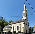
- The Protestant Church of St. Peter and Paul was built in 1838 in the classical style.
- The Catholic Marienkirche was built in 1856 in the classical style.
- Hotel Piast from 1885 is the oldest preserved hotel in the city.
- The Habsburg hunting lodge from 1897 originally stood on the slopes of the Barania Góra and was later moved to the center of the village. It has been used as a PTTK mountain hut since 1987 .
- The presidential palace was built in 1930 in the modern style by Adolf Szyszko-Bohusz .
- Numerous villas from the turn of the century before last.

Beskydy Museum

Catholic Holy Cross Church
Catholic Marienkirche

Hotel Gołębiewski

Habsburg hunting lodge

Presidential Castle


_w_Wi%C5%9Ble_2.JPG)
Ski areas


There are seven larger ski areas with around 30 ski lifts and 20 km of ski slopes in the Wisła municipality .
- Cieńków ski area
- Soszów ski area
- Nowa Osada ski area
- Stożek ski area
- Stok ski area
- Klepki ski area
- Skolnity ski area .
Ski jumping
There are two ski jumps in the Wisła municipality .
Hiking trails

Numerous marked hiking trails leading into the Silesian Beskids begin in Wisła, among others. a. the main Beskydy route :
- ▬ Rozstaje nad Istebną Pietraszonką - Karolówka
- ▬ Wisła Jawornik - Przełęcz Beskidek
- ▬ Głębce - Nowa Osada
- ▬ Czarne - Czarna Wisełka Valley
- ▬ Gościejów - Gościejów Peak
- ▬ Głębce - Łabajów Stożek Wielki - Kiczory
- ▬ Głębce - Kubalonka summit Kubalonka - os. Kozińce - Nowa Osada - os. Wróblonki - Smrekowiec
- ▬ Malinowska Skała - Magurka Wiślańska - Barania Góra - Przysłop - Karolówka
- ▬ Wisła - os. Zdejszy - Wierch Skalnity - os. Skolnity - Soszów Wielki
- ▬ Wisła Dziechcinka - Stożek Wielki - Kiczory
- ▬ Wisła Uzdrowisko - Trzy Kopce Wiślańskie - Przełęcz Salmopolska
- ▬ Głębce - os. Kozińce - Kubalonka - Szarcula
- ▬ Nowa Osada - Cieńków Niżni - Cieńków Wyśni - Gawlasi Groń
- ▬ Wisła Uzdrowisko - Wisła Jawornik - Soszów Mountain Hut
- ▬ Wisła Dziechcinka - os. Kobyla
- ▬ Głębce - os. Mrozków - Stożek Wielki
- ▬ Czarne - Biała Wisełka Valley- Barania Góra - Przysłop - Karolówka
- ▬ Czantoria Wielka - Soszów Wielki - Stożek Wielki - Kubalonka - Przysłop - Barania Góra - Magurka Wiślańska (part of the main Beskydy hiking trail )
- ▬ Przełęcz Salmopolska - Malinów - Malinowska Skała
Long-distance cycle path

Four long-distance cycle routes run through Wisła:
- ▬ Vistula cycle path
- ▬ Cycle route 24C around the Euroregion Cieszyn Silesia
- ▬ Main Carpathian Cycle Route
- Greenways cycle path Krakow - Moravia - Vienna
Local media
From 1993 to 1999 the monthly Informator Miejski Wisły appeared , which was discontinued in February 1999. From March 1999 the monthly magazine Echo Wisły appears .
Population development
- 1910: 4,599 inhabitants
- 1961: 8,692
- 1970: 9,684
- 2007: 11,320
International cooperation
Wisła has the following twin cities:
Personalities
- Jan Kawulok (* 1946 in Wisła), Polish ski jumper and ski jumping coach
- Jerzy Pilch (* 1952 in Wisła; † 2020 in Kielce), Polish writer
- Adam Małysz (* 1977 in Wisła), Polish ski jumper
- Rafał Śliż (* 1983 in Wisła), Polish ski jumper
- Mateusz Wantulok (* 1987 in Wisła), Polish Nordic combined skier
- Paweł Słowiok (* 1992 in Wisła), Polish ski jumper and cross-country skier
Web links
Individual evidence
- ↑ a b population. Size and Structure by Territorial Division. As of June 30, 2019. Główny Urząd Statystyczny (GUS) (PDF files; 0.99 MiB), accessed December 24, 2019 .
- ↑ Główny Urząd Statystyczny, "Ludność - Stan i Struktura w przekroju terytorialnym", as of December 31, 2007 ( Memento of the original of June 27, 2008 in the Internet Archive ) Info: The archive link was inserted automatically and has not yet been checked. Please check the original and archive link according to the instructions and then remove this notice.

