Przełęcz Salmopolska
| Przełęcz Salmopolska | |||
|---|---|---|---|
|
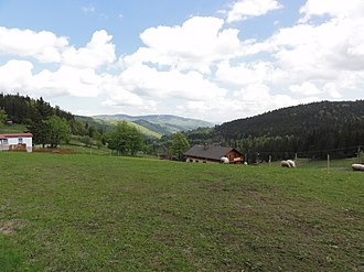
Alm on the pass |
|||
| Compass direction | west | east | |
| Pass height | 934 m npm | ||
| Silesian Beskids , Powiat Cieszyński , Silesia , Poland | Silesian Beskids , Powiat Bielski (Silesia) , Silesia , Poland | ||
| Valley locations | Wisła | Szczyrk | |
| Mountains | Silesian Beskids , West Beskids , Beskids , Carpathians | ||
| map | |||
|
|
|||
| Coordinates | 49 ° 39 '54 " N , 18 ° 57' 38" E | ||
The Przełęcz Salmopolska is a mountain pass in the south of the Polish Silesian Voivodeship in the Silesian Beskids . The pass lies on the border of the municipalities of Wisła and Szczyrk on the Barania ridge and connects the Vistula valley with the Żylica valley . The pass is 934 m high. The pass is named after the formerly independent mountain village of Salmopol , which is now part of Szczyrk.
tourism
- Numerous marked hiking trails lead over the pass. The pass can be reached by car.
literature
- Mirosław J. Barański: Beskid Śląski. Pasmo Stożka i Czantorii. Przewodnik turystyczny . Wyd. Wydawnictwo PTTK “Kraj”, Warszawa 1996, ISBN 83-7005-370-X .
- Mirosław J. Barański: Beskid Śląski: Przewodnik. Oficyna Wydawnicza “Rewasz”, Pruszków 2007, ISBN 978-83-89188-71-7 .
Web links
Commons : Przełęcz Salmopolska - collection of pictures, videos and audio files

