Ludmannsdorf (Pfeffenhausen)
|
Ludmannsdorf
Pfeffenhausen market
Coordinates: 48 ° 41 ′ 37 " N , 11 ° 54 ′ 3" E
|
||
|---|---|---|
| Height : | 474 m above sea level NN | |
| Postal code : | 84076 | |
| Area code : | 08782 | |
|
Location of Ludmannsdorf in Bavaria |
||
|
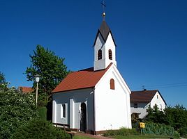
Ludmannsdorf local chapel
|
||
Ludmannsdorf is a district of the market in Pfeffenhausen in the Lower Bavarian district of Landshut .
Geography and transport links
The place is located northwest of the core village Pfeffenhausen on the B 299 on the eastern edge of the village . State road St 2142 runs not far to the north . The Lauterbach , a left tributary of the Große Laber, flows on the southern outskirts .
Attractions
In the list of architectural monuments in Pfeffenhausen , two architectural monuments are listed for Ludmannsdorf :
- The local chapel from around 1900 is a neo-Gothic, massive gable roof building with turrets , plaster and pilaster strips .
- The former smithy with outbuildings (house no. 17) consists of
- the stable house, an eaves solid building from the 19th century with a gred roof
- the former blacksmith's shop, a single-storey gred roof building from 1832 with a flying knee stick


