Luvua
| Luvua | ||
|
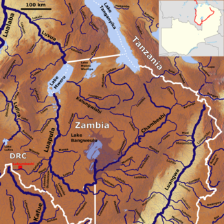
The Luvua river system (Luvua top left) |
||
| Data | ||
| location |
Africa Democratic Republic of the Congo |
|
| River system | Congo | |
| Drain over | Lualaba → Congo → Atlantic Ocean | |
| source |
Mwerusee 8 ° 28 ′ 44 ″ S , 28 ° 53 ′ 23 ″ E |
|
| Source height | 931 m | |
| muzzle | At Ankoro in the Lualaba coordinates: 6 ° 45 ′ 41 ″ S , 26 ° 57 ′ 26 ″ E 6 ° 45 ′ 41 ″ S , 26 ° 57 ′ 26 ″ E |
|
| Mouth height | 557 m | |
| Height difference | 374 m | |
| Bottom slope | 1.1 ‰ | |
| length | 350 km | |
| Catchment area | 265,300 km² | |
| Drain |
MQ |
600 m³ / s |
| Left tributaries | Lubele, Luwe, Lukushi | |
| Right tributaries | Kilulishi, Lukumbi, Lukulu | |
|
Crossing the Luvua near the town of Pweto |
||
The African river Luvua (also Luowa ) is a right tributary of the Congo and the continuation of the Luapula .
course
The river arises on the common border of the Democratic Republic of the Congo and Zambia . It flows from the Mwerusee , which is fed by the Luapula, among other things. From there it flows in a north-westerly direction to later flow into the Lualaba (upper reaches of the Congo).
The Luvua, which is only regarded as a tributary of the Congo, is in connection with its source river Luapula , which arises from the Chambeshi among other things , up to this point significantly longer than the Lualaba , which is considered the actual source river of the Congo.

