Luapula (river)
| Luapula | ||
|
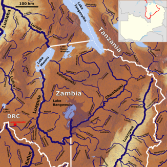
The course of the Luapula with its tributaries (middle left) |
||
| Data | ||
| location |
|
|
| River system | Congo | |
| Drain over | Luvua → Lualaba → Congo → Atlantic | |
| source | Lake Bangweulus outflow | |
| Source height | 1164 m | |
| muzzle | from the south into the Mwerusee Coordinates: 9 ° 23 '33 " S , 28 ° 31' 27" E 9 ° 23 '33 " S , 28 ° 31' 27" E |
|
| Mouth height | 922 m | |
| Height difference | 242 m | |
| Bottom slope | 0.44 ‰ | |
| length | 555 km | |
| Catchment area | 173,386 km² (113,323 km² in Zambia and 60,063 km² in Congo DRC) | |
| Discharge at the gauge Kashiba A Eo : 161,275 km² Location: 150 km above the mouth |
NNQ MNQ 1963-1992 MQ 1963-1992 Mq 1963-1992 MHQ 1963-1992 HHQ |
174 m³ / s 195 m³ / s 741 m³ / s 4.6 l / (s km²) 1758 m³ / s 2012 m³ / s |
| Outflow A Eo : 173,386 km² at the mouth |
MQ Mq |
1,115.5 m³ / s 6.4 l / (s km²) |
| Left tributaries | Chambeshi , Luwombwa , Muniegashi, Lubembe Orientale, Mwati, Kafubu , Lutshipuka, Luala | |
| Right tributaries | Luera, Mansa, Luongo | |
| Navigable | from the Mambilima Falls | |
|
Mouth of the Luapula |
||
The Luapula is the source of the Luvua , which in turn is a right tributary of the Lualaba ( Congo ) in Africa .
course
It is produced in the north of Zambia from the Lake Bangweulu and from the areas adjacent to these Bangweulusümpfen that are fed by numerous small rivers from the surrounding mountains, especially from Chambeshi that near the border with Tanzania between Lake Tanganyika and Lake Malawi springs and these swamps flows . After that, the Luapula is initially a swamp many hundreds of meters wide, the water of which moves southwards. As soon as the river reaches the western plateau, it turns west and forms the border of Zambia with the DR Congo . There follow the deep Mambatutaffalls , behind which the river becomes narrow, meanders to the north and there falls over five kilometers over rapid white water rapids, the Mambilima Falls . Behind these, the valley opens into a meadow landscape characterized by mango trees and cassava fields . After the falls, the river is navigable all the way to the lake. 150 km before the river flows into the Mwerusee, it widens into a wide system of marshes , swamps, lagoons and floodplains. The river changes its name when it flows into the Mwerusee . The outflow of the Mwerusee is called Luvua .
Hydrometry
The flow rate of the Luapula was measured at the Kashiba gauge, almost 150 km from the mouth, between 1963 and 1992 in m³ / s.

Individual evidence
- ↑ a b Google Earth
- ↑ FAO - Source book for the inland fishery resources of Africa Vol. 1
- ↑ a b Water Resources Management Authority (WARMA)
- ↑ a b JICA report

