Chambeshi
|
Chambeshi Chambezi, Tschambesi |
||
|
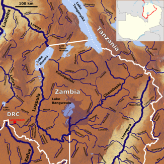
The Chambeshi in the Luvua river system (center right) |
||
| Data | ||
| location |
|
|
| River system | Congo | |
| Drain over | Luapula → Luvua → Congo → Atlantic | |
| source | About 50 km southeast of Lake Tanganyika, 9 ° 5 ′ 50 ″ S , 21 ° 31 ′ 15 ″ E |
|
| Source height | about 1600 m | |
| muzzle | In the Bangweulus swamps in the Luapula coordinates: 11 ° 53 ′ 0 ″ S , 29 ° 48 ′ 0 ″ E 11 ° 53 ′ 0 ″ S , 29 ° 48 ′ 0 ″ E |
|
| Mouth height | 1164 m | |
| Height difference | about 436 m | |
| Bottom slope | about 0.87 ‰ | |
| length | 500 km | |
| Catchment area | 44,427 km² | |
| Discharge at the Chambeshi Pontoon A Eo gauge: 34,745 km² |
NNQ MNQ 1963-1992 MQ 1963-1992 Mq 1963-1992 MHQ 1963-1992 HHQ |
33 m³ / s 40 m³ / s 185 m³ / s 5.3 l / (s km²) 471 m³ / s 582 m³ / s |
| Left tributaries | Karungu, Luwu, Mansya , | |
| Right tributaries | Lukulu , Luansenshi | |
|
The Chambeshi with the Bangweul Marshes |
||
The Chambeshi (also Chambezi or Tschambesi ) is the source river of the Luapula and belongs to the African river system of the Congo .
Course description
It rises in the mountains of northern Zambia not far from the border with Tanzania in the extreme southeast of the Congo catchment area. Its sources are located at an altitude of about 1,600 m above sea level, about 50 km southeast of Lake Tanganyika . The river has a flow path of about 500 km until it meets the Bangweulus swamps, which it flows through in a south-westerly direction. The exact route through the swamps is variable. Some branches of the river flow towards Lake Bangweulus , while others keep the same direction. When leaving the marshes, it joins the Luapula coming from the north from the Bangweulusee, of which it is the most important tributary and which continues to flow as Luvua after crossing the Mweru Lake .
A pontoon bridge spans the river west of Isoka town .
Hydrometry
The flow rate of the Chambeshi was measured in m³ / s at the Chambeshi Pontoon gauge, at about 3/4 of the catchment area.

River history

The current course of the Chambeshi became the drainage route of the river very late in geological terms. For almost the entire Cenozoic era , the river, which today belongs to the Congo catchment area, was a tributary of the Kafue and flowed over the Kafubu . The Kafue for its part also emptied at another point, namely over the Machili into the Zambezi, or the Makgadikgadisee . Thus the Chambeshi was part of the Limpopo catchment before the uplift of the Ovambo-Kalahari-Zimbabwe Fault (OKZ) in the Middle Cenozoic .
Web links
- Congo - the second longest river in Africa on www.youtube.com (2:03 minutes)
Individual evidence
- ↑ Google Earth
- ↑ Soviet General Staff Map , accessed via http://loadmap.net/
- ↑ Water Resources Management Authority (WARMA)
- ↑ JICA publication page 1
- ↑ a b JICA publication, page 18
- ^ Brian Leith (Director): Congo , TV documentary on British Broadcasting Corporation (BBC) , London, 2001.
- ^ The evolution and ages of Makgadikgadi paleo-lakes: consilient evidence from Kalahari drainage evolution south-central Africa
- ^ The Zambezi River - Andy E. Moore, Fenton PD (Woody) Cotterill, Mike PL Main and Hugh B. Williams

