
Lymanske (Jakymiwka)
| Lymanske | |||
| Лиманське | |||

|
|
||
| Basic data | |||
|---|---|---|---|
| Oblast : | Zaporizhia Oblast | ||
| Rajon : | Yakymivka district | ||
| Height : | 8 m | ||
| Area : | 0.436 km² | ||
| Residents : | 186 (2001) | ||
| Population density : | 427 inhabitants per km² | ||
| Postcodes : | 72564 | ||
| Area code : | +380 6131 | ||
| Geographic location : | 46 ° 26 ' N , 35 ° 18' E | ||
| KOATUU : | 2320355403 | ||
| Administrative structure : | 1 village | ||
| Address: | вул. Калініна буд. 67 72563 смт. Кирилівка |
||
| Website : | Kyrylivka Municipal Council website | ||
| Statistical information | |||
|
|||


Lymanske ( Ukrainian Лиманське ; Russian Лиманское Limanskoje ) is a village in the south of the Ukrainian Oblast of Zaporizhia with about 180 inhabitants (2001).
The village, founded in 1820, was called Кучугури Kutschuhury until 1978, when it received its current name.
The village with an area of 0.436 km² belongs administratively to the district council of Kyrylivka in the southeast of the Yakymivka district .
Lymanske lies at a height of 8 m on a peninsula between the Molotschna - and the Utljuk-Liman near the north shore of the Azov Sea . The only road in Lymanske is the Territorial Road Т-08-20, via which the Kyrylivka community center can be reached after 8 km in the south and the district center Jakymiwka after 34 km in the north. The Zaporizhia Oblast Center is 180 km north of the village.

Entrance

Fish stalls on the roadside
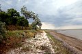
Molochna-Liman near the village


Web links
- Pictures of the location on mapio.net (Ukrainian)
Individual evidence
- ↑ a b c local website on the official website of the Verkhovna Rada ; accessed on May 24, 2019 (Ukrainian)
- ^ Decree of the Presidium of the Verkhovna Rada of February 9, 1978; accessed on May 24, 2019 (Ukrainian)