
Måløybrua
Coordinates: 61 ° 55 ′ 45 ″ N , 5 ° 7 ′ 18 ″ E
| Måløybrua | ||
|---|---|---|
 |
||
| use | Road traffic | |
| Convicted | Riksvei 15 | |
| Crossing of | Måløystraumen (Ulvesund) | |
| place | Måløy | |
| construction | Cantilever bridge | |
| overall length | 1,224 m | |
| Longest span | 125 m | |
| Clear height | 42 m | |
| building-costs | 32 million crowns | |
| start of building | 1971 | |
| completion | December 1973 | |
| opening | June 11, 1974 | |
| toll | until 1984 | |
| location | ||
|
||
| Above sea level | 0 m | |

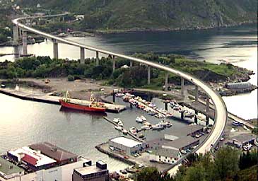
The måløy bridge ( Måløybrücke ) is a 1,224 m long, as a cantilever bridge with a total of 32 pillars built road bridge in the municipality chin in the Norwegian Fylke (Province) Vestland .
The bridge
The Måløy Bridge is the seventh longest bridge in Norway and after its completion it was the longest for a while. It crosses the Måløystraumen, the narrow area at the southern end of the Ulvesund , which separates the large island Vågsøya from the mainland, shortly before the Ulvesund joins the Vågsfjord . It carries Reichsstraße 15 from the mainland near the village of Degnepoll in the east to the island near the town of Måløy in the west. The bridge goes over the small island of Moldøen in Straumen, at the north and south ends of which a beacon safeguards the shipping route through the bridge, which is also used by the Hurtigruten ships . It has a total of 34 arcs; the two middle ones in the shipping channel have a span of 125 meters each and a clearance height of 42 meters.


history
Construction began in 1971 and in December 1973 the bridge was opened to traffic. The official opening took place on June 11, 1974 by King Olav V , who returned from a state visit to Iceland on the state yacht Norge and was one day late due to bad weather. The construction cost 32 million Norwegian kroner and was financed by a toll levied by the bridge users . The costs had already been paid off three years before the estimated date, so the bridge has been toll-free since 1984.
Wind speed indicator
The bridge is built in such a way that it can withstand winds of up to 75 m / s - more than twice the wind speed of a hurricane of wind force 12. Since road vehicles are no longer safe on a high bridge at much lower wind speeds, there are both at both At the ends of the bridge there are wind warning boards as a warning, and the bridge has been closed several times for safety reasons.
Curiosity
If the wind blows with a certain strength from a certain direction, the bridge sounds with a " high C ".