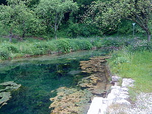
Mühlbachquelle (Dietfurt an der Altmühl)
| Mühlbachquelle | |||
|---|---|---|---|
 The Mühlbachquelle in Mühlbach |
|||
| location | |||
| Country or region | District of Neumarkt in der Oberpfalz , Upper Palatinate ( Bavaria ) | ||
| Coordinates | 49 ° 1 ′ 22 " N , 11 ° 37 ′ 6" E | ||
| height | 370 m above sea level NN | ||
|
|||
| geology | |||
| Mountains | Franconian Alb | ||
| Source type | Karst spring | ||
| Exit type | Hill debris source | ||
| Hydrology | |||
| River system | Danube | ||
| Receiving waters | Mühlbach → Altmühl → Danube → Black Sea | ||
| Bulk | 300 l / s | ||
| depth | 2 m | ||
Coordinates: 49 ° 1 ′ 22 ″ N , 11 ° 37 ′ 6 ″ E
The Mühlbachquelle (also Great Mühlbachquelle ) is a karst spring in Mühlbach , a district of the Upper Palatinate city of Dietfurt in the Neumarkt district in Bavaria .
It is part of the Altmühltal Nature Park and the Franconian Alb .
description

The Mühlbachquelle is located in the Mühlbach district , which occupies the entire width of a small valley that is dry above it and runs south to the Altmühl, at 370 m above sea level. NN at the left foot of the slope. The karst spring of the Mühlbach pours an average of around 300 liters of water per second from the Mühlbachquell cave , making it one of the strongest karst springs in Bavaria. The water that emerges has a temperature of 8 ° C all year round. It is dammed by a weir about 2 meters high to a source pond, which is under monument protection , and still drives the water wheel of the so-called Obermühle. Marking tests showed the connection with a field of sinkholes east of Eutenhofen in the dry so-called Thanngründltal , which lies around 4 km northeast of the source around a hundred meters further up on the plateau.
The spring is often incorrectly referred to as a spring pot , but this is not true because it arises in the rubble. About a hundred meters further south, at about the same height and also on the eastern edge of the village, there is another source, the drainage of which joins the large Mühlbach spring west of the local church .
Geotope
The source is designated by the Bavarian State Office for the Environment as geotope 373Q001 and a natural monument .
Access
The fenced-in area around the spring outlet is privately owned and can only be entered during guided tours.
Remarks
- ^ Location of the sinkhole field east of Eutenhofen
- ↑ Geotope: Karst spring Mühlbach (accessed on August 22, 2013; PDF; 182 kB)
See also
- List of karst springs in Bavaria
- List of geotopes in the Neumarkt district in the Upper Palatinate
- List of natural monuments in the Neumarkt district in the Upper Palatinate
Web links
- Karst spring Mühlbach in the geotope register Bavaria (PDF; 182 kB)
