Maʿale Efraim
|
Ma'ale Ephraim מַעֲלֵה אֶפְרַיִם معلي افرايم |
||
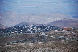
 View of Ma'ale Efraim from the west |
||
| Territory : |
West Bank ( Judea and Samaria ) |
|
| Founded : | 1978 | |
| Coordinates : | 32 ° 4 ' N , 35 ° 24' E | |
| Height : | 959 m | |
| Residents : | 1,206 (2015) | |
| Mayor : | Shlomo Lalosh | |
|
|
||
Ma'ale Efrayim ( Hebrew מַעֲלֵה אֶפְרַיִם, eng. Rise of Ephraim) is a secular Israeli settlement ; In this context, secular means that the Jewish religious traditions are no longer viewed strictly, although traditional Jewish festivals are celebrated. It is located on the southern slopes of Samaria in the Jordan Valley in the West Bank . The settlement was founded in 1978 and named after the biblical tribe of the Ephraim . The city status was changed in 1989, since then it has been a local association . The international community believes that the Israeli settlements in the West Bank were illegally established under international law , which the Israeli government denies.
Web links
Commons : Ma'ale Efrayim - collection of images, videos and audio files
Individual evidence
- ↑ Archived copy ( Memento of the original from May 17, 2018 in the Internet Archive ) Info: The archive link was inserted automatically and has not yet been checked. Please check the original and archive link according to the instructions and then remove this notice.
- ^ Ministry of Defense Publishing House; Jerusalem (Ed.): Carta's official guide to Israel: and complete gazetteer to all sites in the Holy land. Carta, Israel 1993, ISBN 965-220-186-3 .
- ↑ מעלה אפרים | מועצה מקומית מעלה אפרים. In: co.il. maaleefraim.co.il, accessed February 15, 2017 (he-IL).
- ^ BBC News - The Geneva Convention. In: co.uk. news.bbc.co.uk, accessed February 15, 2017 (British English).
