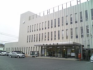
Maebaru
| Maebaru-shi (incorporated) 前 原 市 |
||
|---|---|---|
| Geographical location in Japan | ||
|
|
||
| Region : | Kyushu | |
| Prefecture : | Fukuoka | |
| Coordinates : | 33 ° 33 ' N , 130 ° 12' E | |
| Basic data | ||
| Incorporated on: | Jan. 1, 2010 | |
| Incorporated in: | Itoshima | |
| Surface: | 104.50 km² | |
| Residents : | 68,583 (November 1, 2009) |
|
| Population density : | 656 inhabitants per km² | |
| Community key : | 40222-2 | |
| Symbols | ||
| Tree : | Maple , cherry | |
| Flower : | Garden chrysanthemum | |
| town hall | ||
| Address : |
Maebaru City Hall 1 - 1 - 1 , Maebaru-Nishi Maebaru -shi Fukuoka 819-1192 |
|
| Website URL: | http://www.city.maebaru.fukuoka.jp | |
| Location Maebarus in Fukuoka Prefecture | ||
Maebaru ( Japanese 前 原 市 , - shi ) was a city in Fukuoka Prefecture in Japan .
geography
Maebaru is west of Fukuoka and north of Saga .
history
The city of Maebaru was founded on October 1, 1992. On January 1, 2010, she united with Shima and Nijō to form the Itoshima community .
traffic
- Streets:
- National Road 202
- Railroad:
Neighboring cities and communities
Web links
Commons : Maebaru - collection of images, videos and audio files


