Mangere
|
Mangere Māori: Māngere |
||
| District of | Manukau City | |
| Geographical location | ||
|
|
||
| Coordinates | 36 ° 58 ′ S , 174 ° 48 ′ E | |
| Region ISO | NZ-AUK | |
| country | New Zealand | |
| region | Auckland | |
| District | Auckland Council | |
| Ward | Manukau Ward | |
| Residents | 62 748 (2013) | |
| height | 10 m | |
| Post Code | 2022, 2024 | |
| Telephone code | +64 0 (9) | |
| Photography of the district | ||
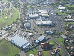
 Center of Mangere seen from the air |
||
| Remarks | ||
| Manukau City was independent until October 2010 and then became part of the Auckland Council on November 1, 2010 | ||
Mangere is a district of the former independent city of Manukau City on the North Island of New Zealand .
Origin of name
The word Māngere means something like “lazy”, “slow”, “lazy” or “idle” in the Māori language .
geography
Mangere is located around 10 km south-southeast of downtown Auckland on Manukau Harbor , which encloses the west of the district. The district of Otahuhu joins in the northeast, the Papatoetoe district in the east and the Manurewa district in the southeast . Administratively, Mangere belongs to the Manukau Ward .
Mangere is divided into the districts of Ambury , Aorere, Arahanga , Favona North, Favona South, Favona West, Harania East, Harania North, Harania West , Mangere Bridge , Mangere Central , Mangere East , Mangere South , Mangere Station , Mascat and Viscount .
At the 2013 census, the district had 62,748 inhabitants.
Māngere Mountain
In the Mangere district there are seven formerly active volcanoes , of which Mount Mangere is the largest and most famous of them with a height of 106 m . They are all part of the Auckland Volcanic Field , which extends over 53 previously active volcanoes in the core of the Auckland region. The Mount Mangere emerged with his first eruption about 70,000 years ago. Its erupted lava spread over five square kilometers on all sides and shaped the current topology of the district.
The education center Māngere Mountain emerged from the community of the Mangere Bridge district . It has set itself the task of conveying to interested parties and visitors something about the history of the city district, about the earlier Māori settlement, about the volcano and its geological composition and something about the natural landscape that developed on it.
Infrastructure
Road traffic
Mangere is crossed by the New Zealand State Highway 20 coming from the north over the Mangere Bridge , which represents an important relief of the north-south traffic for the New Zealand State Highway 1 , which runs further east, and at the same time the district of Mount Roskill north on the other side of the Manukau Harbors with Mangere . Within the district of Mangere branches in two places in the center and southeast of the New Zealand State Highway 20 A and the New Zealand State Highway 20 B from New Zealand State Highway 20 , and binds the airport from Auckland to the network of New Zealand State Highways on.
Air traffic
Auckland Airport is located in the southern part of Mangere and handles the vast majority of international air traffic between New Zealand and the rest of the world. The airport is by far the most important hub in the country for all domestic flights.
Individual evidence
- ↑ a b c 2013 Census QuickStats about a place : Mangere-Otahuhu Local Board Area . Statistics New Zealand , 2013, accessed on May 16, 2018 (English, StatsMap: Meshblock evaluation via the interactive map of the subdivisions: Ambury , Aorere, Arahanga , Favona North, Favona South, Favona West, Harania East, Harania North, Harania West , Mangere Bridge , Mangere Central , Mangere East , Mangere South , Mangere Station , Mascat and Viscount ).
- ↑ a b c Topo250 maps . Land Information New Zealand , accessed May 16, 2018 .
- ↑ Mangere . In: New Zealand History . Ministry for Culture & Heritage , accessed on May 16, 2018 .
- ↑ māngere . In: Maori Dictionary . John C. Moorfield , accessed May 16, 2018 .
- ↑ Coordinates and longitudes were determined using Goggle Earth Pro Version 7.3.1.4507 on May 16, 2018
- ^ Geology . Mangere Mountain , accessed May 16, 2018 .
- ↑ Visit . Mangere Mountain , accessed May 16, 2018 .

