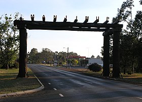
Manjimup
| Manjimup | |||||||
|---|---|---|---|---|---|---|---|
 Entrance |
|||||||
|
|||||||
|
|||||||
|
|||||||
|
|||||||
|
|
|||||||
Manjimup is a town in Western Australia , 300 kilometers south of Perth . It is located on the South Western Highway halfway between Bunbury and Denmark . The city of Manjimup is the center of the Shire of the same name , the largest in southwest Western Australia. At the 2016 census, there were 4,213 people in the city.
history
Manjimup is in the words of the Noongar - Aboriginal manjin (edible broad-leaved cattail ) and up (place of). The first settler in Manjimup was the woodcutter Thomas Muir, who settled in the area in 1856. Some of the houses of these early settlers still stand today, such as Giblett's House from 1870 and Dingup Church from 1896. In 1910 the small town was named a town and the Perth Railway was completed in 1911.
The population continued to increase, as Manjimup after World War part of the Group Settlement Scheme was. Soldiers and immigrants should find a new home here. However, the project was a failure, as the reclamation of the land was very difficult for inexperienced farmers due to the huge trees and impenetrable undergrowth. The project finally failed when dairy prices collapsed during the Great Depression in the 1930s.
economy
Industry
The main industry in this region is still the timber industry, followed by agricultural production of vegetables and fruits, wool and wine. Tobacco was also grown and processed here until the 1960s .
Manjimup is the leading Australian producer of Perigord black truffles . Cultivation began in 1997 when 16,000 hazelnut trees, the roots of which were inoculated with the truffle spores, were planted. In 2006, 125 kilograms could be harvested, a year later even 400 kilograms.
Since the beginning of the 21st century, the Department of Agriculture and Food has been investigating whether it is possible to cultivate green tea in this area. Manjimup is at the same distance from the equator as the classic tea-growing areas of the northern hemisphere and has the same amount of precipitation, average temperature and soil quality. Experiments with ten different types of tea should show which type is best.
tourism
Tourist attractions are the 51 meter high fire lookout point Diamond Tree , the “Four Aces” - four 75 meter high, over 400 years old carribrees ( Eucalyptus diversicolor ), the “One Tree Bridge” - a bridge consisting of a single carribean and the “Manjimup” Timber Park ”, a museum about the history of the city and the timber industry.
climate
Manjimup has a mild Mediterranean climate with cold, humid winters and warm, dry summers (category Csb according to Köppen and Geiger).
|
Average Monthly Temperatures and Rainfall for MANJIMUP - Altitude: 287m from 1936 to 2009
Source: Australian Government - Bureau of Meteorology
|
|||||||||||||||||||||||||||||||||||||||||||||||||||||||||||||||||||||||||||||||||||||||||||||||||||||||||
Web links
Individual evidence
- ↑ a b Climate statistics for Australian locations (MANJIMUP) ( English ) Australian Government - Bureau of Meteorologie . Retrieved February 5, 2010.
- ↑ a b Australian Bureau of Statistics : Manjimup (Urban Center / Locality) ( English ) In: 2016 Census QuickStats . June 27, 2017. Retrieved April 7, 2020.
- ↑ Shire of Manjimup: A Brief History ( en ) Archived from the original on December 12, 2007. Information: The archive link was automatically inserted and has not yet been checked. Please check the original and archive link according to the instructions and then remove this notice. Retrieved February 5, 2010.
- ↑ a b c d Travel: Manjimup . In: The Sydney Morning Herald . February 8, 2004 ( online [accessed February 5, 2010]).
- ↑ Getaway fact sheets: Manjimup truffles ( en ) Archived from the original on May 19, 2006. Info: The archive link has been inserted automatically and has not yet been checked. Please check the original and archive link according to the instructions and then remove this notice. Retrieved February 5, 2010.
- ↑ Judith Elen: WA truffles in black gold rush . In: The Australia . July 14, 2007 ( online [accessed February 5, 2010]).
- ^ John Burt: Growing green tea in Western Australia: Development of a green tea industry in the Manjimup / Pemberton area . Bulletin 4499. Ed .: Government of Western Australia: Department of Agriculture and Food. June 2001 ( online [accessed February 13, 2010]). online ( Memento of the original from December 25, 2012 in the Internet Archive ) Info: The archive link was inserted automatically and has not yet been checked. Please check the original and archive link according to the instructions and then remove this notice.
- ↑ World Maps of the Köppen-Geiger climate classification updated.


