
Marienhof (Flensburg)
,_Bild_01.jpg)
,_Bild_02.jpg)
Marienhof in Flensburg is a residential area in the Westliche Höhe district near St. Gertrud , which originated as an agricultural business . The listed residential building at Nerongsallee 22 remained from the courtyard .
history
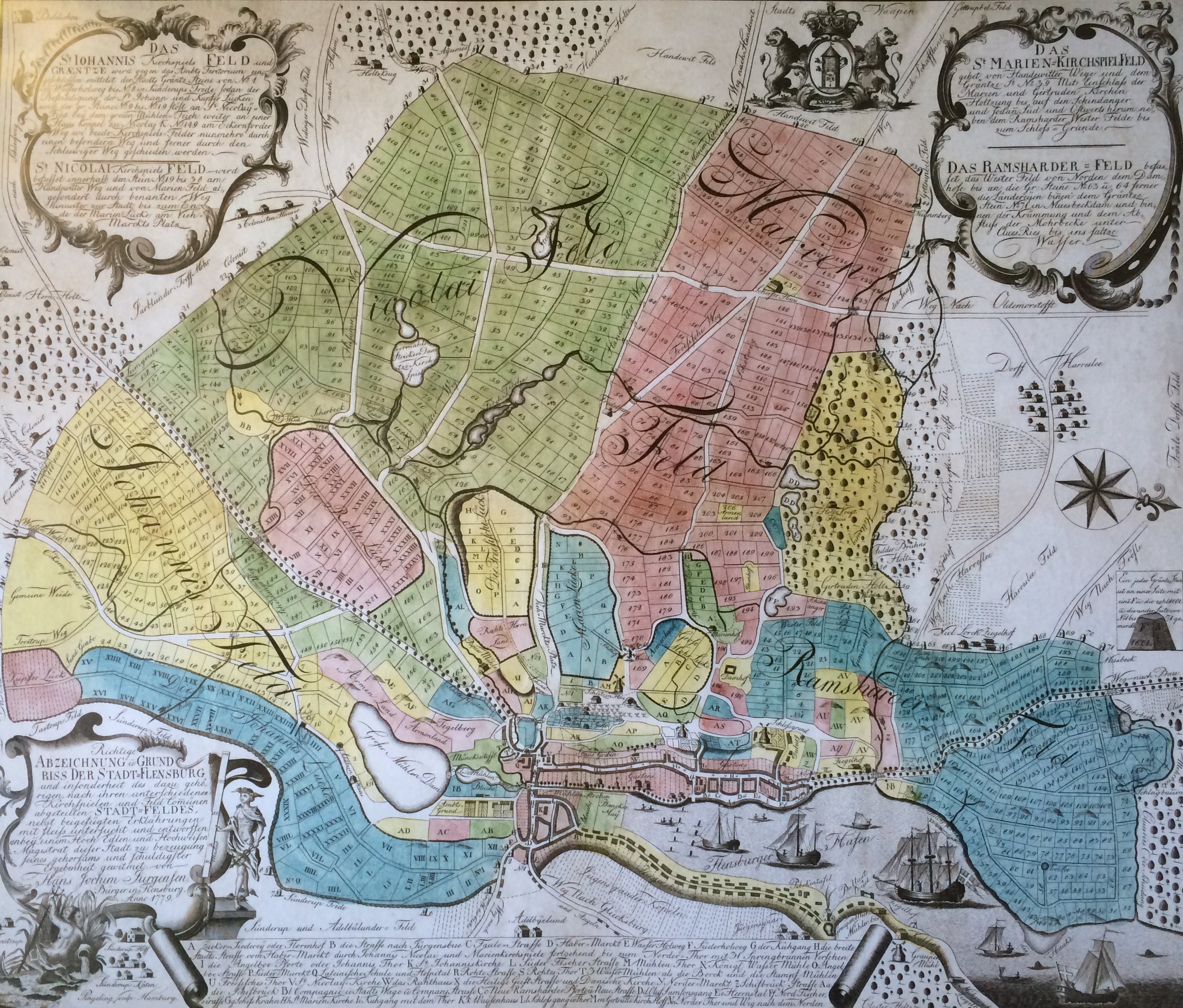
The area there was in the 18th century in the so-called Marienfeld of the parish of St. Marien . In 1777, the Kommerzienrat Peter Hallensen (1715–1796) received an exceptional permit, contrary to an existing construction ban with regard to the city field, to set up an agricultural operation there. Hallensen, sometimes also called Hollensen, built a four-sided courtyard , a four-sided, closed courtyard area, to manage the area . For a long time the Marienhof was the only real farm on the Stadtfeld.
An extensive garden belonged to the courtyard and was expanded by the subsequent owners. A landscape park was created that stretched from the corner of Nerongsallee / Marienhölzungsweg to the Schützenhof sports field ( Lage ). A dirt road ran through the landscape park until the first half of the 19th century, which was later partially converted into a road. This street was named Wrangelstrasse at the end of the 19th century . The park-like facility, in the style of an English garden , had an avenue-like tree planting, several watercourses and fish ponds, a hill and a summer house.
The best- known successor owner of the Marienhof was Gottfried Johan Nerong (* 1765 in Sønderborg ; † 1838 in Flensburg), who worked as a merchant, hospital manager, city councilor and royal Danish agent and senator. Nerong used the farm as a country residence. The Nerongsallee, which runs past the courtyard, was named after Nerong. A renovation of the courtyard building took place in 1841, among other things.
Around 1900 there was a lot of building activity in the area. On a map from the 1920s, Marienhof was still shown as a largely undeveloped area. The closed housing estate Marienhof ( Lage ) was built in the west of the originally agricultural area in the 1920s . The facility in question shows a slight similarity to the park courtyard in the Mürwik district . In contrast to this, it is kept simpler. In the apartment buildings and terraced houses of the Marienhof housing estate, mainly employees of the Flensburg tax office were accommodated. On October 14, 1924, the street of the housing estate was officially named "Marienhof". In 2019 the said residential complex was also placed under monument protection.
The rest of the meadows were then built with single-family houses. On a map from 1936, the area was largely designated as built-up. In the 1950s, the St. Marien congregation erected the St. Gertrud church building on the corner of Hermann-Löns-Weg / Marienhölzungsweg No. 51 , which gave its name to the district of the same name, in which Marienhof is also located.
The residential house ( location ) that has been preserved from the courtyard is a broad, single-storey eaves house with a crooked hip roof and a bat dormer . The simple building was later divided into several apartments. The entrance is on the courtyard side. On the side facing Nerongsallee, the window openings were partially bricked up. On the south side of the gable there is a sandstone plaque with the year of construction.
Web links
Individual evidence
- ↑ Gerret Liebing Schlaber: From the country to the district. Flensburg's Stadtfeld and the incorporated villages in pictures and words approx. 1860–1930 . Flensburg 2009, p. 74.
- ^ City districts, published by the City of Flensburg ( Memento from February 24, 2016 in the Internet Archive )
- ↑ Gerret Liebing Schlaber: From the country to the district. Flensburg's Stadtfeld and the incorporated villages in pictures and words approx. 1860–1930 . Flensburg 2009, p. 74.
- ^ Lutz Wilde : Monument topography Federal Republic of Germany, cultural monuments in Schleswig-Holstein. Volume 2, Flensburg, p. 432. f.
- ↑ Map of Flensburg and the surrounding area 1779 , accessed on: February 4, 2018
- ↑ Flensburg Atlas, Flensburg 1978, maps 10 and 11
- ↑ Flensburg street names . Society for Flensburg City History, Flensburg 2005, ISBN 3-925856-50-1 , article: Marienhof
- ↑ Gerret Liebing Schlaber: From the country to the district. Flensburg's Stadtfeld and the incorporated villages in pictures and words approx. 1860–1930 . Flensburg 2009, p. 74.
- ^ Andreas Oeding, Broder Schwensen, Michael Sturm: Flexikon. 725 aha experiences from Flensburg! Flensburg 2009, article: Marienhof
- ^ Lutz Wilde : Monument topography Federal Republic of Germany, cultural monuments in Schleswig-Holstein. Volume 2, Flensburg, p. 432.
- ↑ Gerret Liebing Schlaber: From the country to the district. Flensburg's Stadtfeld and the incorporated villages in pictures and words approx. 1860–1930 . Flensburg 2009, p. 74.
- ^ Andreas Oeding, Broder Schwensen, Michael Sturm: Flexikon. 725 aha experiences from Flensburg! Flensburg 2009, article: Marienhof
- ↑ Flensburg street names . Society for Flensburg City History, Flensburg 2005, ISBN 3-925856-50-1 , article: Marienhof
- ^ Lutz Wilde : Monument topography Federal Republic of Germany, cultural monuments in Schleswig-Holstein. Volume 2, Flensburg, p. 432. f.
- ↑ Gerret Liebing Schlaber: From the country to the district. Flensburg's Stadtfeld and the incorporated villages in pictures and words approx. 1860–1930 . Flensburg 2009, p. 74.
- ^ Andreas Oeding, Broder Schwensen, Michael Sturm: Flexikon. 725 aha experiences from Flensburg! Flensburg 2009, article: Marienhof
- ^ Andreas Oeding, Broder Schwensen, Michael Sturm: Flexikon. 725 aha experiences from Flensburg! Flensburg 2009, article: Marienhof
- ↑ Flensburg street names . Society for Flensburg City History, Flensburg 2005, ISBN 3-925856-50-1 , article: Marienhof
- ↑ Flensburg street names . Society for Flensburg City History, Flensburg 2005, ISBN 3-925856-50-1 , article: Marienhof
- ^ Andreas Oeding, Broder Schwensen, Michael Sturm: Flexikon. 725 aha experiences from Flensburg! Flensburg 2009, article: Marienhof
- ↑ Museums Nord, portrait of Gottfried Johann Nerong , accessed on: February 4, 2018
- ↑ Niels Nikolaus Falck : New citizenship magazine with special consideration for the duchies of Schleswig, Holstein and Lauenburg, Volume 2 , page 653, accessed on: February 4, 2018
- ^ Lutz Wilde : Monument topography Federal Republic of Germany, cultural monuments in Schleswig-Holstein. Volume 2, Flensburg, p. 432.
- ^ Lutz Wilde : Monument topography Federal Republic of Germany, cultural monuments in Schleswig-Holstein. Volume 2, Flensburg, p. 432. f.
- ^ Andreas Oeding, Broder Schwensen, Michael Sturm: Flexikon. 725 aha experiences from Flensburg! Flensburg 2009, article: Marienhof
- ^ Map of Flensburg (south) from 1926 , accessed on: February 4, 2018
- ↑ See design statutes Marienhof (2001) , accessed on: January 24, 2019
- ↑ Flensburger Tageblatt : Plans for residential quarters: Exclusive living at the water tower , from: October 2, 2013; accessed on: February 9, 2018
- ↑ Gerret Liebing Schlaber: From the country to the district. Flensburg's Stadtfeld and the incorporated villages in pictures and words approx. 1860–1930 . Flensburg 2009, p. 74.
- ↑ The Marienhof housing estate was largely protected by a design statute in 2000 . See design statutes. Marienhof settlement , accessed on: February 4, 2018
- ↑ Flensburg street names . Society for Flensburg City History, Flensburg 2005, ISBN 3-925856-50-1 , article: Marienhof
- ↑ List of monuments Flensburg City of Flensburg (March 18, 2019)
- ↑ Gerret Liebing Schlaber: From the country to the district. Flensburg's Stadtfeld and the incorporated villages in pictures and words approx. 1860–1930 . Flensburg 2009, p. 74.
- ↑ Map Flensburg (South) from 1936 , accessed on: February 4, 2018
- ^ City districts, published by the City of Flensburg ( Memento from February 24, 2016 in the Internet Archive )
- ^ Lutz Wilde : Monument topography Federal Republic of Germany, cultural monuments in Schleswig-Holstein. Volume 2, Flensburg, p. 432. f.
Coordinates: 54 ° 47 ′ 15.5 ″ N , 9 ° 25 ′ 1 ″ E